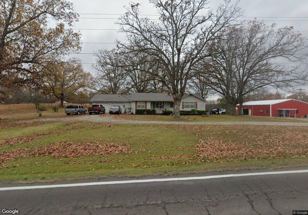
10203 State Route 17 West Plains, MO 65775
Estimated Value: $173,771 - $498,000
--
Bed
--
Bath
1,532
Sq Ft
$191/Sq Ft
Est. Value
About This Home
This home is located at 10203 State Route 17, West Plains, MO 65775 and is currently estimated at $291,943, approximately $190 per square foot. 10203 State Route 17 is a home with nearby schools including Glenwood Elementary School and Faith Assembly Christian School.
Ownership History
Date
Name
Owned For
Owner Type
Purchase Details
Closed on
Oct 4, 2019
Sold by
Torretta Robin D and Torretta Terry J
Bought by
Bivens Ellen E and Revocable Trust Agmt Of Ellen E Bivens
Current Estimated Value
Purchase Details
Closed on
Jun 16, 2006
Sold by
Torretta Robin Dawn Cawvey and Torretta Terry J
Bought by
Torretta Robin D and Torretta Terry J
Home Financials for this Owner
Home Financials are based on the most recent Mortgage that was taken out on this home.
Original Mortgage
$112,800
Interest Rate
6.67%
Mortgage Type
New Conventional
Create a Home Valuation Report for This Property
The Home Valuation Report is an in-depth analysis detailing your home's value as well as a comparison with similar homes in the area
Home Values in the Area
Average Home Value in this Area
Purchase History
| Date | Buyer | Sale Price | Title Company |
|---|---|---|---|
| Bivens Ellen E | -- | Powell Crews T&E Co Llc | |
| Torretta Robin D | -- | Waco Title |
Source: Public Records
Mortgage History
| Date | Status | Borrower | Loan Amount |
|---|---|---|---|
| Previous Owner | Torretta Robin D | $112,800 |
Source: Public Records
Tax History Compared to Growth
Tax History
| Year | Tax Paid | Tax Assessment Tax Assessment Total Assessment is a certain percentage of the fair market value that is determined by local assessors to be the total taxable value of land and additions on the property. | Land | Improvement |
|---|---|---|---|---|
| 2025 | $869 | $24,070 | $5,530 | $18,540 |
| 2024 | $792 | $21,490 | -- | -- |
| 2023 | $792 | $21,490 | $0 | $0 |
| 2022 | $755 | $20,490 | $0 | $0 |
| 2021 | $727 | $20,490 | $0 | $0 |
| 2020 | $727 | $19,150 | $0 | $0 |
| 2019 | $762 | $19,150 | $0 | $0 |
| 2018 | $739 | $18,580 | $0 | $0 |
| 2017 | $724 | $18,580 | $0 | $0 |
| 2015 | -- | $18,580 | $0 | $0 |
| 2014 | -- | $18,580 | $0 | $0 |
| 2013 | -- | $18,580 | $0 | $0 |
Source: Public Records
Map
Nearby Homes
- 000 County Road 8800
- 000 State Route 17 S
- 9744 County Road 8270
- 0 Lanton Rd
- 9871 Private Road 8291
- 000 Arrowhead Acres
- 10567 County Road 8130
- 9888 County Road 8490
- 000 Private Road 8825
- 5019 Private Road 8948
- 000 County Road 8190
- 10068 County Road 8490
- 10733 County Road 8070
- 000 the Timbers
- 5038 County Road 8940
- 9845 County Road 8530
- 1239 County Road 8620
- 9681 Private Road 6685
- Lot #1 County Road 8510
- 552 County Road 8500
- 10212 State Route 17
- 5614 Private Road 8880
- 10195 Missouri 17
- 10200 State Route 17
- 5635 County Road 8800
- 5620 Private Road 8880
- 10261 State Route 17
- 5620 County Road 8800
- 10153 State Route 17
- 5675 County Road 8800
- 10318 State Route 17
- 10323 Missouri 17
- 000 Private Road 9892
- 10326 State Route 17
- 10323 State Route 17
- 6039 Private Road 8882 Unit 8882
- 6039 Private Road 8882
- 10137 State Route 17
- 10122 State Route 17