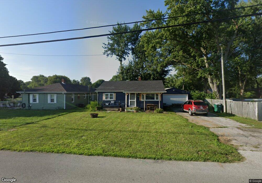
1021 Hamilton Ave Franklin, IN 46131
Estimated Value: $125,000 - $184,000
2
Beds
1
Bath
720
Sq Ft
$217/Sq Ft
Est. Value
About This Home
This home is located at 1021 Hamilton Ave, Franklin, IN 46131 and is currently estimated at $156,382, approximately $217 per square foot. 1021 Hamilton Ave is a home located in Johnson County with nearby schools including Northwood Elementary School, Franklin Community Middle School, and Custer Baker Intermediate School.
Ownership History
Date
Name
Owned For
Owner Type
Purchase Details
Closed on
Jun 22, 2023
Sold by
Snyder Lyman A and Snyder Corbalou A
Bought by
Hessman Charles
Current Estimated Value
Home Financials for this Owner
Home Financials are based on the most recent Mortgage that was taken out on this home.
Original Mortgage
$109,300
Outstanding Balance
$106,356
Interest Rate
6.35%
Mortgage Type
VA
Estimated Equity
$50,026
Create a Home Valuation Report for This Property
The Home Valuation Report is an in-depth analysis detailing your home's value as well as a comparison with similar homes in the area
Home Values in the Area
Average Home Value in this Area
Purchase History
| Date | Buyer | Sale Price | Title Company |
|---|---|---|---|
| Hessman Charles | -- | Alliance Title |
Source: Public Records
Mortgage History
| Date | Status | Borrower | Loan Amount |
|---|---|---|---|
| Open | Hessman Charles | $109,300 |
Source: Public Records
Tax History Compared to Growth
Tax History
| Year | Tax Paid | Tax Assessment Tax Assessment Total Assessment is a certain percentage of the fair market value that is determined by local assessors to be the total taxable value of land and additions on the property. | Land | Improvement |
|---|---|---|---|---|
| 2025 | $2,139 | $125,100 | $7,800 | $117,300 |
| 2024 | $2,139 | $96,700 | $7,800 | $88,900 |
| 2023 | $2,125 | $95,500 | $7,800 | $87,700 |
| 2022 | $2,101 | $94,200 | $7,800 | $86,400 |
| 2021 | $1,833 | $82,200 | $5,800 | $76,400 |
| 2020 | $1,795 | $80,500 | $5,800 | $74,700 |
| 2019 | $1,776 | $79,400 | $5,800 | $73,600 |
| 2018 | $3,630 | $64,300 | $5,800 | $58,500 |
| 2017 | $1,327 | $65,600 | $5,800 | $59,800 |
| 2016 | $1,167 | $65,600 | $5,800 | $59,800 |
| 2014 | $1,050 | $52,800 | $9,200 | $43,600 |
| 2013 | $1,050 | $52,400 | $9,100 | $43,300 |
Source: Public Records
Map
Nearby Homes
- 651 Hamilton Ave
- 1110 Hillview Dr
- 750 Hurricane St
- 1130 E Adams Dr
- 1121 E Adams Dr
- 698 Yandes St
- 351 Cincinnati St
- 601 Duane St
- 348 Ohio St
- 991 Ravine Dr
- 298 N Water St
- 147 E King St
- 1083 Beechtree Ln
- 1185 Beechtree Ln
- 150 E Madison St
- 1682 Millpond Ln
- 1669 Millpond Ln
- 1646 Millpond Ln
- 1636 Millpond Ln
- 1679 Millpond Ln
- 835 N Forsythe St
- 896 Glendale Dr
- 1001 Hamilton Ave
- 833 N Forsythe St
- 831 N Forsythe St
- 894 Glendale Dr
- 899 Glendale Dr
- 990 Hamilton Ave
- 820 N Forsythe St
- 892 Glendale Dr
- 897 Glendale Dr
- 980 Hamilton Ave
- 860 Glendale Dr
- 895 Glendale Dr
- 732 N Forsythe St
- 999 Hamilton Ave
- 890 Glendale Dr
- 850 N Forsythe St
- 800 N Forsythe St