


10220 Kangaroo Mine Rd Shasta, CA 96001
Shasta NeighborhoodEstimated payment $1,051/month
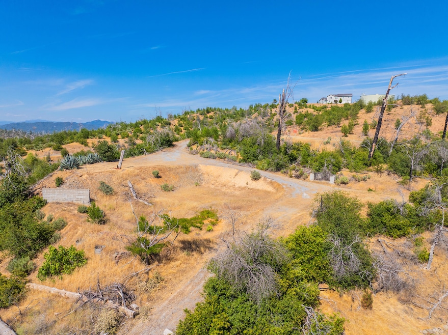
About This Lot
Discover the opportunity to own a 4.07 acre parcel of land with sweeping mountain views, including a direct Mt. Shasta View in a peaceful and private setting. This property, once home to mature trees and natural beauty, was affected by the CARR Fire. While the fire left its mark, it also opened up expansive vistas and a unique blank canvas for your vision.
Located in a desirable area known for its scenic surroundings and tranquil atmosphere, this lot offers a chance to rebuild or start fresh. With ample space for your dream home, outbuildings, or a retreat, the land is ready for revitalization. Utilities are nearby, septic and water are in and access is convenient from the main road.
Whether you're looking to invest, build, or simply own a piece of mountain paradise, this fire-impacted property presents incredible potential with the promise of renewal.
Property Details
Property Type
- Land
Est. Annual Taxes
- $1,483
Lot Details
- 4.07 Acre Lot
- Dirt Road
- Zoning described as SC - R-R - Rural Residential District
Listing and Financial Details
- Assessor Parcel Number 204-090-017-000
Map
Home Values in the Area
Average Home Value in this Area
Tax History
| Year | Tax Paid | Tax Assessment Tax Assessment Total Assessment is a certain percentage of the fair market value that is determined by local assessors to be the total taxable value of land and additions on the property. | Land | Improvement |
|---|---|---|---|---|
| 2025 | $1,483 | $140,000 | $140,000 | -- |
| 2024 | $1,470 | $140,000 | $140,000 | -- |
| 2023 | $1,470 | $140,000 | $140,000 | $0 |
| 2022 | $1,461 | $140,000 | $140,000 | $0 |
| 2021 | $1,356 | $130,000 | $130,000 | $0 |
| 2020 | $1,372 | $130,000 | $130,000 | $0 |
| 2019 | $1,308 | $130,000 | $130,000 | $0 |
| 2018 | $7,007 | $668,000 | $157,000 | $511,000 |
| 2017 | $6,897 | $652,000 | $150,000 | $502,000 |
| 2016 | $6,204 | $610,000 | $140,000 | $470,000 |
| 2015 | $6,143 | $603,750 | $136,500 | $467,250 |
| 2014 | $5,891 | $575,000 | $130,000 | $445,000 |
Property History
| Date | Event | Price | Change | Sq Ft Price |
|---|---|---|---|---|
| 06/30/2025 06/30/25 | For Sale | $170,000 | -- | -- |
Purchase History
| Date | Type | Sale Price | Title Company |
|---|---|---|---|
| Deed | -- | Deanne E Parker Aplc | |
| Grant Deed | $229,000 | Chicago Title Co |
Source: Shasta Association of REALTORS®
MLS Number: 25-2995
APN: 204-090-017-000
Disclaimer: Certain information contained herein is derived from information provided by parties other than Homes.com. All information provided is deemed reliable, but is not guaranteed to be accurate and should be independently verified.
![]() IDX information is provided exclusively for personal, non-commercial use, and may not be used for any purpose other than to identify prospective properties consumers may be interested in purchasing. Information is deemed reliable but not guaranteed.
IDX information is provided exclusively for personal, non-commercial use, and may not be used for any purpose other than to identify prospective properties consumers may be interested in purchasing. Information is deemed reliable but not guaranteed.
- 15599 Sugar Cone Ln
- .63 acre Lot Swasey Dr
- 15698 California 299
- 15809 Old Stage Coach Rd
- 10255 Carrousel Dr
- 15778 Highland Cir
- 15691 Old Stage Coach Rd
- 10241 Winthrop Ct
- 10249 Carrousel Dr
- 15455 Middle Creek Rd
- 15938 Highland Cir
- 15952 Highland Cir
- 15943 Highland Cir
- 10156 Victoria Dr
- 10123 Victoria Dr
- 0 High St
- 000 High St
- 10670 High St
- 15907 Cindee Ln
- 0 Mule Mountain Pkwy
- 3610 Scenic Dr
- 568 Royal Oaks Dr
- 3022 Lake Redding Dr
- 1534 Fig Ave
- 2430 Lake Redding Dr
- 2142 Butte St
- 2045 Shasta St
- 1559 Willis St
- 2172 West St
- 1895 Benton Dr
- 1551 Market St
- 1046 Continental St Unit 4
- 1765 Laurel Ave Unit Condo Left
- 706 State St
- 2635 Russell St
- 335 Lake Blvd Unit 335 Lake Blvd. 0
- 540 South St
- 500 Hilltop Dr
- 814 Mission de Oro Dr
- 1230 Canby Rd
