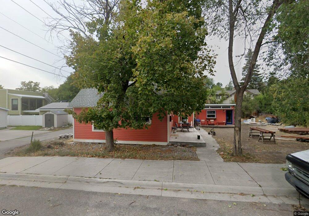
1023 Van Buren St Missoula, MT 59802
Lower Rattlesnake NeighborhoodEstimated Value: $479,143 - $533,000
2
Beds
1
Bath
932
Sq Ft
$533/Sq Ft
Est. Value
About This Home
This home is located at 1023 Van Buren St, Missoula, MT 59802 and is currently estimated at $496,786, approximately $533 per square foot. 1023 Van Buren St is a home located in Missoula County with nearby schools including Rattlesnake Elementary School, Washington Middle School, and Hellgate High School.
Ownership History
Date
Name
Owned For
Owner Type
Purchase Details
Closed on
Oct 26, 2012
Sold by
Deschamps Robert L and Deschamps Bob
Bought by
Deschamps Robert L and Deschamps Marnie J
Current Estimated Value
Purchase Details
Closed on
Oct 12, 2012
Sold by
Gardiner Michael F
Bought by
Deschamps Bob
Purchase Details
Closed on
Aug 14, 2009
Sold by
Gardiner Michael F and Estate Of Charlotte E Gardiner
Bought by
Gardiner Tony
Create a Home Valuation Report for This Property
The Home Valuation Report is an in-depth analysis detailing your home's value as well as a comparison with similar homes in the area
Home Values in the Area
Average Home Value in this Area
Purchase History
| Date | Buyer | Sale Price | Title Company |
|---|---|---|---|
| Deschamps Robert L | -- | None Available | |
| Deschamps Bob | -- | None Available | |
| Gardiner Tony | -- | None Available |
Source: Public Records
Tax History Compared to Growth
Tax History
| Year | Tax Paid | Tax Assessment Tax Assessment Total Assessment is a certain percentage of the fair market value that is determined by local assessors to be the total taxable value of land and additions on the property. | Land | Improvement |
|---|---|---|---|---|
| 2025 | $4,519 | $425,136 | $218,946 | $206,190 |
| 2024 | $4,242 | $348,662 | $200,922 | $147,740 |
| 2023 | $4,188 | $348,662 | $200,922 | $147,740 |
| 2022 | $3,732 | $268,600 | $0 | $0 |
| 2021 | $3,263 | $268,600 | $0 | $0 |
| 2020 | $3,144 | $216,828 | $0 | $0 |
| 2019 | $3,093 | $212,768 | $0 | $0 |
| 2018 | $3,120 | $209,080 | $0 | $0 |
| 2017 | $2,447 | $204,200 | $0 | $0 |
| 2016 | $2,908 | $206,300 | $0 | $0 |
| 2015 | $2,713 | $206,300 | $0 | $0 |
| 2014 | $2,807 | $120,840 | $0 | $0 |
Source: Public Records
Map
Nearby Homes
- 838 Locust St
- 1132 Jackson St
- 1116 Vine St
- 1110 Vine St
- 1811 Elison Ln
- 416 E Pine St
- 2201 Greenough Ct W
- 111 N 2nd St W
- 8862 Santa Anita Rd
- 8876 Santa Anita Rd
- 516 S 5th St E
- 2215 Raymond Ave
- 1227 Basecamp Dr Unit A
- 1250 Basecamp Dr Unit F
- 1250 Basecamp Dr Unit C
- 322 W Alder St
- 5237 Ginger Quill Rd Unit B
- 5237 Ginger Quill Rd Unit A
- 542 Eddy Ave
- 1025 Grand Ave Unit 4