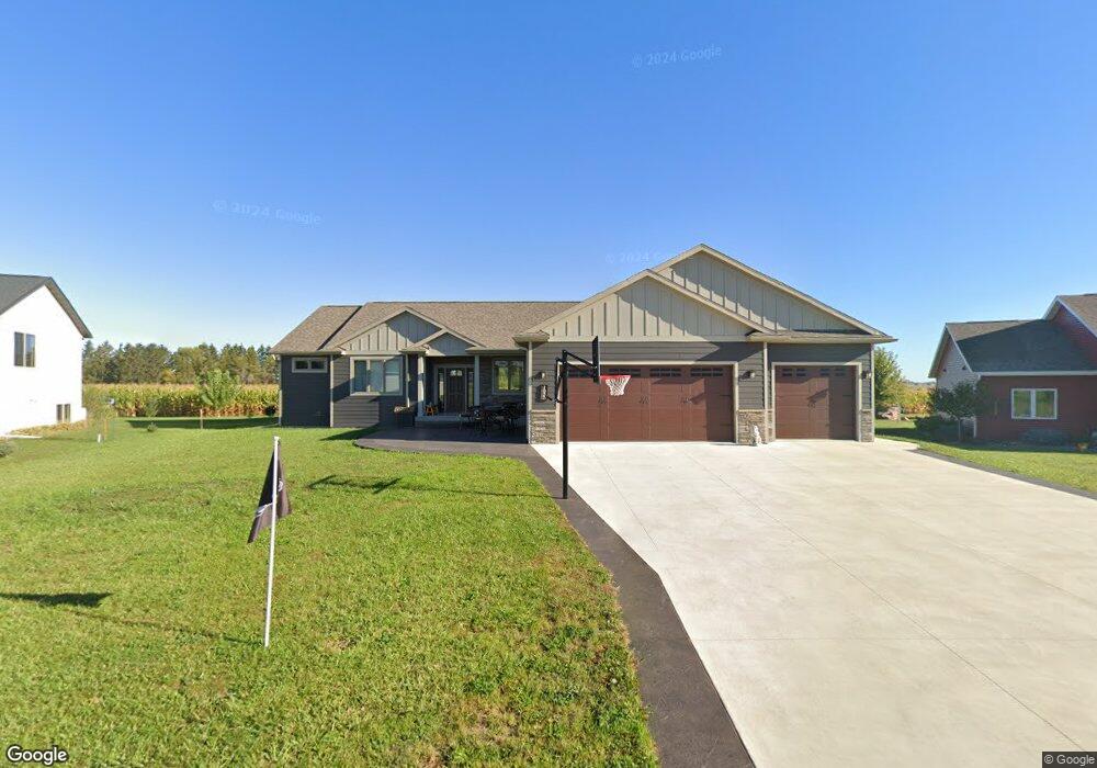
1027 Bucknell Ct Spring Valley, MN 55975
Estimated Value: $384,000 - $516,000
4
Beds
--
Bath
1,952
Sq Ft
$227/Sq Ft
Est. Value
About This Home
This home is located at 1027 Bucknell Ct, Spring Valley, MN 55975 and is currently estimated at $443,888, approximately $227 per square foot. 1027 Bucknell Ct is a home with nearby schools including Kingsland Elementary School, Kingsland Middle School, and Kingsland Junior/Senior High School.
Ownership History
Date
Name
Owned For
Owner Type
Purchase Details
Closed on
Jan 28, 2021
Sold by
K5 Prop Llc
Bought by
Bernard Gregory and Bernard Tallie
Current Estimated Value
Purchase Details
Closed on
May 1, 2017
Sold by
Kolling Aaron R and Kolling Toni
Bought by
K5 Properies Llc
Purchase Details
Closed on
Apr 30, 2017
Sold by
Kolling Bros Llc
Bought by
Kolling Aaron R and Kolling Matthew T
Purchase Details
Closed on
Dec 31, 2012
Sold by
Bucknell Bruce E and Bucknell Linda M
Bought by
Kolling Bros Llc
Create a Home Valuation Report for This Property
The Home Valuation Report is an in-depth analysis detailing your home's value as well as a comparison with similar homes in the area
Purchase History
| Date | Buyer | Sale Price | Title Company |
|---|---|---|---|
| Bernard Gregory | $34,900 | None Available | |
| K5 Properies Llc | $92,555 | None Available | |
| K5 Properies Llc | -- | None Available | |
| Kolling Aaron R | -- | None Available | |
| Kolling Bros Llc | $132,000 | None Available | |
| Bernard Gregory Gregory | $34,900 | -- |
Source: Public Records
Tax History
| Year | Tax Paid | Tax Assessment Tax Assessment Total Assessment is a certain percentage of the fair market value that is determined by local assessors to be the total taxable value of land and additions on the property. | Land | Improvement |
|---|---|---|---|---|
| 2025 | $6,924 | $461,100 | $21,000 | $440,100 |
| 2024 | $6,924 | $412,700 | $21,000 | $391,700 |
| 2023 | $6,514 | $412,700 | $21,000 | $391,700 |
| 2022 | $468 | $21,000 | $21,000 | $0 |
| 2021 | $468 | $21,000 | $21,000 | $0 |
| 2020 | $464 | $21,000 | $21,000 | $0 |
| 2019 | $454 | $21,000 | $21,000 | $0 |
| 2018 | -- | $21,000 | $21,000 | $0 |
| 2017 | -- | $21,000 | $21,000 | $0 |
| 2016 | $418 | $21,000 | $21,000 | $0 |
| 2015 | $384 | $21,000 | $21,000 | $0 |
| 2014 | $384 | $21,000 | $21,000 | $0 |
| 2013 | $384 | $19,200 | $19,200 | $0 |
Source: Public Records
Map
Nearby Homes
- XXX 256th St
- 712 Memorial Dr
- 528 N Broadway St
- 79275 267th St
- 501 Maple Lane Ave
- 313 N Hudson Ave
- 321 N Section Ave
- 309 Center Ave
- 209 N Section Ave
- 78946 280th St
- TBD Harrison Ave NE
- 15151 304th St
- xxx Highway 63
- 204 Diamond Ct
- 203 Diamond Ct
- 205 Diamond Ct
- 206 Diamond Ct
- 200 Diamond Ct
- 114 Fillmore St E
- 527 Elliot Dr SE
- 1007 Bucknell Ct
- 1021 Bucknell Ct
- 1016 Bucknell Ct
- 1026 Bucknell Ct
- 1031 Bucknell Ct
- 11639 County 8
- 11644 County 8
- xxx County 8 Rd
- 11941 256th St
- 11882 County 8
- 11416 County 8
- 11299 County 2
- 11373 County 2
- 11996 Quilt Rd
- 25722 125th Ave
- 11510 County 8
- 11817 Rambling Rd
- XXXX Co Rd 8
- 12067 County 8
- 11802 Rambling Rd
Your Personal Tour Guide
Ask me questions while you tour the home.