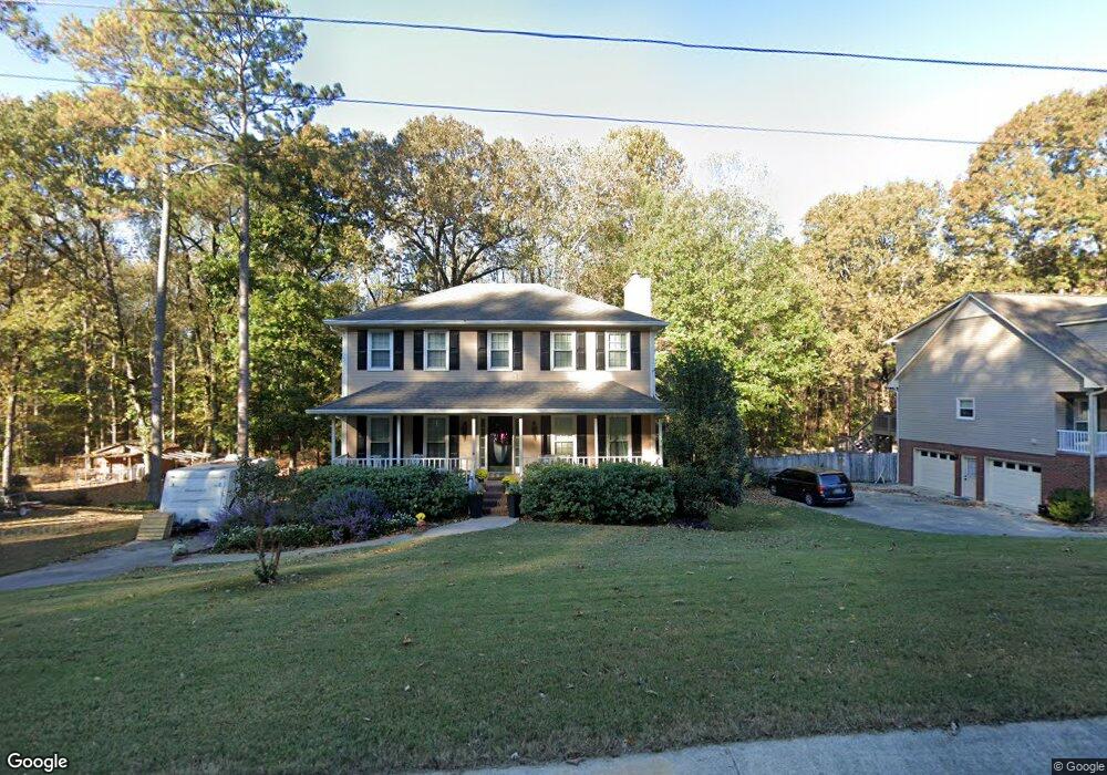
1031 Independence Ct Alabaster, AL 35007
Estimated Value: $332,610 - $374,000
4
Beds
4
Baths
2,143
Sq Ft
$163/Sq Ft
Est. Value
About This Home
This home is located at 1031 Independence Ct, Alabaster, AL 35007 and is currently estimated at $348,403, approximately $162 per square foot. 1031 Independence Ct is a home located in Shelby County with nearby schools including Thompson Intermediate School, Thompson Middle School, and Thompson High School.
Ownership History
Date
Name
Owned For
Owner Type
Purchase Details
Closed on
May 29, 2009
Sold by
Respinto Marco J and Respinto Laura A
Bought by
Kopp Kathleen E
Current Estimated Value
Home Financials for this Owner
Home Financials are based on the most recent Mortgage that was taken out on this home.
Original Mortgage
$191,075
Outstanding Balance
$120,984
Interest Rate
4.81%
Mortgage Type
FHA
Estimated Equity
$227,419
Purchase Details
Closed on
Mar 13, 2003
Sold by
Sparks David C and Sparks Wendy L
Bought by
Respinto Marco J and Respinto Laura A
Home Financials for this Owner
Home Financials are based on the most recent Mortgage that was taken out on this home.
Original Mortgage
$121,600
Interest Rate
5.88%
Purchase Details
Closed on
Apr 6, 1998
Sold by
Carley David I and Carley Lori Jean
Bought by
Sparks David C and Sparks Wendy L
Home Financials for this Owner
Home Financials are based on the most recent Mortgage that was taken out on this home.
Original Mortgage
$118,000
Interest Rate
7.04%
Create a Home Valuation Report for This Property
The Home Valuation Report is an in-depth analysis detailing your home's value as well as a comparison with similar homes in the area
Home Values in the Area
Average Home Value in this Area
Purchase History
| Date | Buyer | Sale Price | Title Company |
|---|---|---|---|
| Kopp Kathleen E | -- | None Available | |
| Respinto Marco J | $152,000 | -- | |
| Sparks David C | $136,000 | -- |
Source: Public Records
Mortgage History
| Date | Status | Borrower | Loan Amount |
|---|---|---|---|
| Open | Kopp Kathleen E | $191,075 | |
| Previous Owner | Respinto Marco J | $121,600 | |
| Previous Owner | Sparks David C | $118,000 |
Source: Public Records
Tax History Compared to Growth
Tax History
| Year | Tax Paid | Tax Assessment Tax Assessment Total Assessment is a certain percentage of the fair market value that is determined by local assessors to be the total taxable value of land and additions on the property. | Land | Improvement |
|---|---|---|---|---|
| 2024 | $1,636 | $30,300 | $0 | $0 |
| 2023 | $1,450 | $27,620 | $0 | $0 |
| 2022 | $1,394 | $26,580 | $0 | $0 |
| 2021 | $1,219 | $23,340 | $0 | $0 |
| 2020 | $1,155 | $22,140 | $0 | $0 |
| 2019 | $1,075 | $20,660 | $0 | $0 |
| 2017 | $998 | $19,240 | $0 | $0 |
| 2015 | $950 | $18,360 | $0 | $0 |
| 2014 | $927 | $17,920 | $0 | $0 |
Source: Public Records
Map
Nearby Homes
- 1121 Colonial Dr
- 1910 Amberley Woods Trail
- 1909 Amberley Woods Trail
- 1445 Sequoia Trail
- 905 Navajo Trail
- 1317 W Navajo Dr
- 105 Acorn Cir
- 1117 Amberley Woods Dr
- 834 Burning Tree Trail
- 1445 Navajo Trail
- 220 Navajo Pines Dr
- 100 Cape Cod Cir
- 1238 Bennett Dr
- 0001 9th St NW
- 000 9th St NW
- 1807 Apache Way
- 152 Roy Ct
- 2916 Dublin Dr N
- 513 Bennett Dr
- 1805 Mohawk Dr
- 1033 Independence Ct
- 1029 Independence Ct
- 1025 Independence Ct
- 1035 Independence Ct
- 1030 Independence Ct
- 1028 Independence Ct
- 1032 Independence Ct
- 1037 Independence Ct
- 1024 Independence Ct
- 1034 Independence Ct
- 1103 Independence Dr
- 1036 Independence Ct
- 1039 Independence Ct
- 1105 Independence Dr
- 1017 Independence Ct
- 1101 Independence Dr
- 1025 Independence Dr
- 1107 Independence Dr
- 1016 Independence Ct
- 1021 Independence Dr