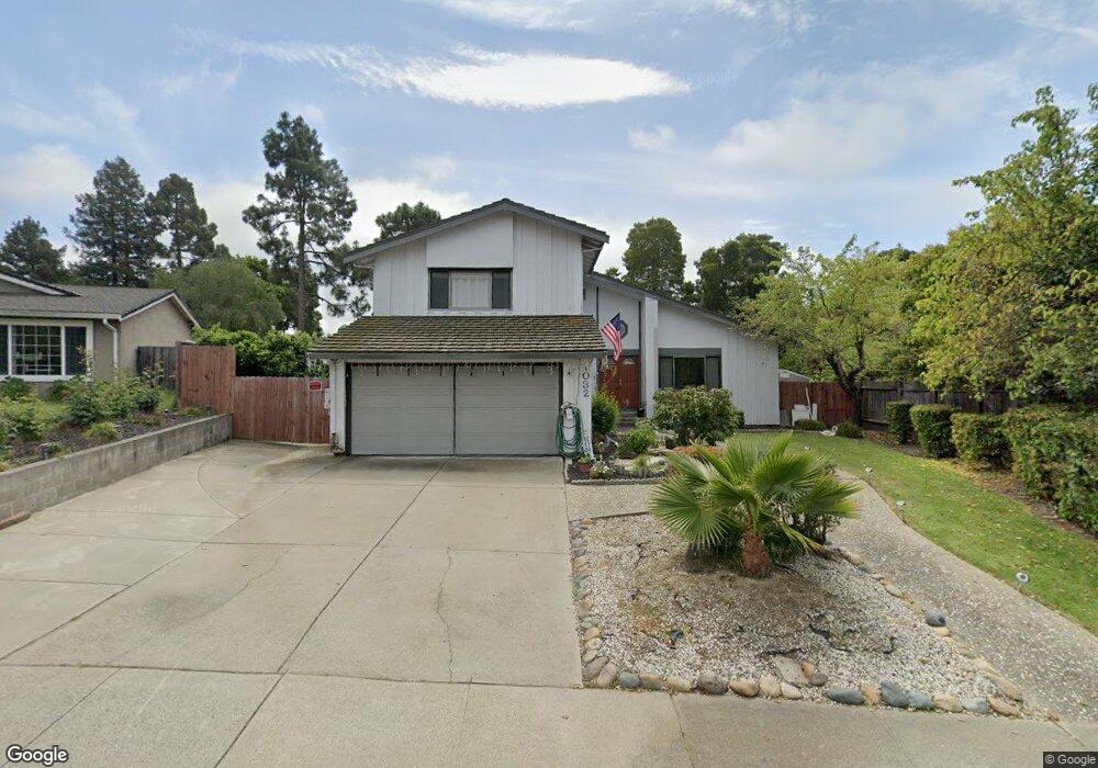
1032 Baypoint Way Rodeo, CA 94572
View Pointe NeighborhoodEstimated Value: $775,020 - $929,000
4
Beds
3
Baths
1,927
Sq Ft
$439/Sq Ft
Est. Value
About This Home
This home is located at 1032 Baypoint Way, Rodeo, CA 94572 and is currently estimated at $845,505, approximately $438 per square foot. 1032 Baypoint Way is a home located in Contra Costa County with nearby schools including Rodeo Hills Elementary School, Carquinez Middle School, and John Swett High School.
Ownership History
Date
Name
Owned For
Owner Type
Purchase Details
Closed on
Dec 8, 2000
Sold by
Lighty Michael H & Zoe R Tre
Bought by
Malhi Amar Singh and Malhi Kulwant Kaur
Current Estimated Value
Home Financials for this Owner
Home Financials are based on the most recent Mortgage that was taken out on this home.
Original Mortgage
$271,250
Outstanding Balance
$99,742
Interest Rate
7.67%
Mortgage Type
Stand Alone First
Estimated Equity
$745,763
Create a Home Valuation Report for This Property
The Home Valuation Report is an in-depth analysis detailing your home's value as well as a comparison with similar homes in the area
Home Values in the Area
Average Home Value in this Area
Purchase History
| Date | Buyer | Sale Price | Title Company |
|---|---|---|---|
| Malhi Amar Singh | $310,000 | Old Republic Title Company |
Source: Public Records
Mortgage History
| Date | Status | Borrower | Loan Amount |
|---|---|---|---|
| Open | Malhi Amar Singh | $271,250 | |
| Closed | Malhi Amar Singh | $62,000 |
Source: Public Records
Tax History Compared to Growth
Tax History
| Year | Tax Paid | Tax Assessment Tax Assessment Total Assessment is a certain percentage of the fair market value that is determined by local assessors to be the total taxable value of land and additions on the property. | Land | Improvement |
|---|---|---|---|---|
| 2025 | $6,832 | $467,098 | $111,493 | $355,605 |
| 2024 | $6,783 | $457,940 | $109,307 | $348,633 |
| 2023 | $6,783 | $448,962 | $107,164 | $341,798 |
| 2022 | $6,650 | $440,160 | $105,063 | $335,097 |
| 2021 | $6,519 | $431,530 | $103,003 | $328,527 |
| 2019 | $6,359 | $418,733 | $99,949 | $318,784 |
| 2018 | $6,185 | $410,524 | $97,990 | $312,534 |
| 2017 | $6,074 | $402,475 | $96,069 | $306,406 |
| 2016 | $5,595 | $394,585 | $94,186 | $300,399 |
| 2015 | $5,546 | $388,659 | $92,772 | $295,887 |
| 2014 | $5,473 | $381,046 | $90,955 | $290,091 |
Source: Public Records
Map
Nearby Homes
- 839 Reef Point Dr
- 839 Coral Dr
- 1112 Dennis Ct
- 789 Coral Ridge Cir
- 1119 Claeys Ct
- 943 Coral Ridge Cir
- 996 Coral Ridge Cir
- 748 Windward Dr
- 405 Weymouth
- 802 Dover
- 720 Seacliff Ct
- 1006 Chelsea
- 836 Hawthorne Dr
- 725 Vaqueros Ave
- 1124 Mahoney St
- 544 Napa Ave
- 1096 Flowering Ash Dr
- 1186 Waverly Cir
- 808 4th St
- 220 Vaqueros Ave
- 1034 Baypoint Way
- 1030 Baypoint Way
- 1028 Baypoint Way
- 1066 Sandpoint Dr
- 1062 Sandpoint Dr
- 1031 Baypoint Way
- 1070 Sandpoint Dr
- 1058 Sandpoint Dr
- 1026 Baypoint Way
- 1025 Baypoint Way
- 919 Sandy Cove Dr
- 913 Sandy Cove Dr
- 1056 Sandpoint Dr
- 1072 Sandpoint Dr
- 925 Sandy Cove Dr
- 907 Sandy Cove Dr
- 1022 Baypoint Way
- 931 Sandy Cove Dr
- 1052 Sandpoint Dr
- 1023 Baypoint Way