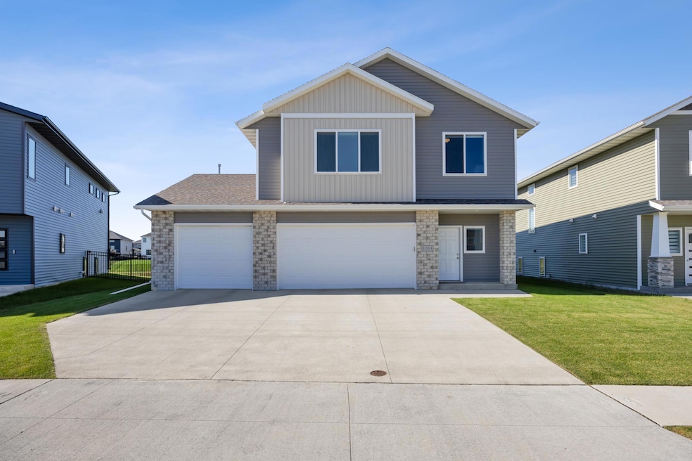
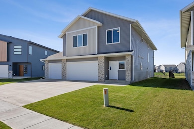
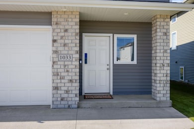
1033 Ashley Dr W Riverside, ND 58078
The Wilds NeighborhoodEstimated payment $3,370/month
Highlights
- Deck
- Cathedral Ceiling
- 3 Car Attached Garage
- Legacy Elementary School Rated A-
- No HOA
- 4-minute walk to Dakota Park
About This Home
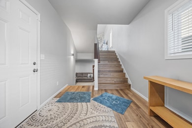
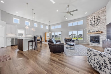
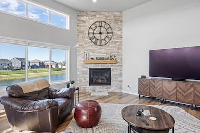
Welcome home to this beautifully upgraded 4 bedroom, 3 bath property with a spacious 3-stall heated garage—featuring an extra 4’ added to the back for bonus storage or workspace! Situated on a large pond lot, this home offers both comfort and functionality inside and out. Located near Dakota Park, which features pickleball courts, playground equipment and a covered picnic area!
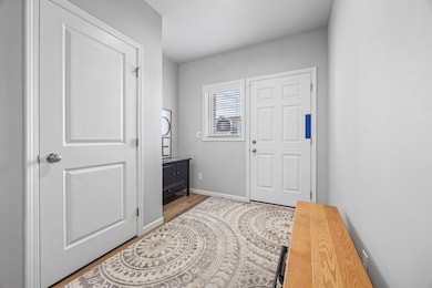
Enjoy the open floor plan featuring cathedral ceilings and tons of windows that fill the space with natural light. Durable LVP flooring extends throughout the foyer, stairs, and living areas, creating a seamless and inviting flow. Relax by the stunning gas fireplace with full stone surround, and entertain with ease as the kitchen and dining areas open to the maintenance-free deck overlooking the fenced backyard and serene pond views—perfect for outdoor gatherings.
Unwind in the spacious primary suite featuring a large walk-in closet and double sinks in the private 3/4 bath. The finished 4th level provides additional living space, while thoughtful upgrades throughout include closet organizers, an active radon mitigation system, air exchanger, furnace humidifier, and in-ground sprinkler system to keep your lawn looking its best.
This home truly checks all the boxes—move in and enjoy!
Home Details
Home Type
- Single Family
Est. Annual Taxes
- $4,378
Year Built
- Built in 2021
Lot Details
- 0.31 Acre Lot
- Lot Dimensions are 52 x 186 x 92 x 186
- Split Rail Fence
Parking
- 3 Car Attached Garage
- Parking Storage or Cabinetry
- Heated Garage
- Insulated Garage
- Garage Door Opener
Home Design
- Split Level Home
- Vinyl Siding
Interior Spaces
- Cathedral Ceiling
- Stone Fireplace
- Gas Fireplace
- Entrance Foyer
- Family Room
- Living Room with Fireplace
- Dining Room
- Utility Room
- Utility Room Floor Drain
Kitchen
- Range
- Microwave
- Dishwasher
Bedrooms and Bathrooms
- 4 Bedrooms
Laundry
- Laundry Room
- Dryer
- Washer
Finished Basement
- Sump Pump
- Drain
- Basement Storage
Additional Features
- Deck
- Forced Air Heating and Cooling System
Community Details
- No Home Owners Association
- The Wilds 15Th Add Subdivision
Listing and Financial Details
- Assessor Parcel Number 02583900090000
Map
Home Values in the Area
Average Home Value in this Area
Tax History
| Year | Tax Paid | Tax Assessment Tax Assessment Total Assessment is a certain percentage of the fair market value that is determined by local assessors to be the total taxable value of land and additions on the property. | Land | Improvement |
|---|---|---|---|---|
| 2024 | $7,603 | $186,950 | $43,100 | $143,850 |
| 2023 | $7,568 | $167,100 | $43,100 | $124,000 |
| 2022 | $6,925 | $142,600 | $43,100 | $99,500 |
| 2021 | $3,442 | $25,150 | $25,150 | $0 |
| 2020 | $2,043 | $25,150 | $25,150 | $0 |
Property History
| Date | Event | Price | List to Sale | Price per Sq Ft |
|---|---|---|---|---|
| 11/20/2025 11/20/25 | Price Changed | $569,000 | -1.0% | $196 / Sq Ft |
| 10/06/2025 10/06/25 | For Sale | $575,000 | -- | $198 / Sq Ft |
Purchase History
| Date | Type | Sale Price | Title Company |
|---|---|---|---|
| Warranty Deed | $248,742 | The Title Company | |
| Warranty Deed | -- | The Title Company | |
| Warranty Deed | -- | The Title Company |
Mortgage History
| Date | Status | Loan Amount | Loan Type |
|---|---|---|---|
| Open | $437,000 | New Conventional | |
| Closed | $437,000 | New Conventional |
Source: NorthstarMLS
MLS Number: 6800637
APN: 02-5839-00090-000
Disclaimer: Certain information contained herein is derived from information provided by parties other than Homes.com. All information provided is deemed reliable, but is not guaranteed to be accurate and should be independently verified.
![]() Based on information submitted to the MLS GRID. All data is obtained from various sources and may not have been verified by broker or MLS GRID. Supplied Open House Information is subject to change without notice. All information should be independently reviewed and verified for accuracy. Properties may or may not be listed by the office/agent presenting the information. Some IDX listings have been excluded from this website.
Based on information submitted to the MLS GRID. All data is obtained from various sources and may not have been verified by broker or MLS GRID. Supplied Open House Information is subject to change without notice. All information should be independently reviewed and verified for accuracy. Properties may or may not be listed by the office/agent presenting the information. Some IDX listings have been excluded from this website.
The Digital Millennium Copyright Act of 1998, 17 U.S.C. § 512 (the “DMCA”) provides recourse for copyright owners who believe that material appearing on the Internet infringes their rights under U.S. copyright law. If you believe in good faith that any content or material made available in connection with our website or services infringes your copyright, you (or your agent) may send us a notice requesting that the content or material be removed, or access to it blocked.
Notices must be sent in writing by email to DMCAnotice@MLSGrid.com.
The DMCA requires that your notice of alleged copyright infringement include the following information:
(1) description of the copyrighted work that is the subject of claimed infringement;
(2) description of the alleged infringing content and information sufficient to permit us to locate the content;
(3) contact information for you, including your address, telephone number and email address;
(4) a statement by you that you have a good faith belief that the content in the manner complained of is not authorized by the copyright owner, or its agent, or by the operation of any law;
(5) a statement by you, signed under penalty of perjury, that the information in the notification is accurate and that you have the authority to enforce the copyrights that are claimed to be infringed; and
(6) a physical or electronic signature of the copyright owner or a person authorized to act on the copyright owner’s behalf. Failure to include all of the above information may result in the delay of the processing of your complaint.
- 1025 Ashley Dr W
- 1001 Ashley Dr W
- 977 Ashley Dr W
- 5476 Lori Ln W
- 5460 11th St W
- 5219 11th St W
- 811 Cathy Dr W
- 1050 Albert Dr W
- 1105 Jill Dr W
- 1129 Jill Dr W
- 5810 James Dr W
- Rockford Plan at The Wilds - The Wilds 21st Addition
- 5816 James Dr W
- Kittson Plan at The Wilds - The Wilds 21st Addition
- Pinehurst Plan at The Wilds - The Wilds 21st Addition
- Douglas Plan at The Wilds - The Wilds 21st Addition
- Kittson II Plan at The Wilds - The Wilds 21st Addition
- Hudson Plan at The Wilds - The Wilds 21st Addition
- Augusta Plan at The Wilds - The Wilds 21st Addition
- Archer Plan at The Wilds - The Wilds 21st Addition
- 5476 Lori Ln W
- 1001 60th Ave W
- 6751 66th Ave S
- 6747 66th Ave S
- 6715 66th Ave S
- 6733 67th Ave S
- 6718 68th St S
- 3412 5th St W
- 3435 5th St W
- 639 33rd Ave W
- 3252 6th St W
- 5124 48th Ave S
- 7994 Jacks Way
- 3900 S 56th St
- 360 32nd Ave W
- 3150 Sheyenne St
- 320 32nd Ave
- 862 36th Ave E
- 5652 36th Ave S
- 2920 Sheyenne St
