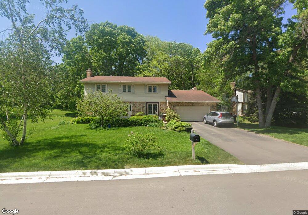
1033 Brompton Place Saint Paul, MN 55118
Estimated Value: $634,998 - $724,000
4
Beds
3
Baths
2,360
Sq Ft
$283/Sq Ft
Est. Value
About This Home
This home is located at 1033 Brompton Place, Saint Paul, MN 55118 and is currently estimated at $668,750, approximately $283 per square foot. 1033 Brompton Place is a home located in Dakota County with nearby schools including Somerset Elementary School, Heritage E-STEM Magnet School, and Two Rivers High School.
Ownership History
Date
Name
Owned For
Owner Type
Purchase Details
Closed on
Jun 28, 2016
Sold by
Shapiro Daniel J and Shapiro Emily F
Bought by
Casserly Michael G and Jaworski Sonya A
Current Estimated Value
Home Financials for this Owner
Home Financials are based on the most recent Mortgage that was taken out on this home.
Original Mortgage
$338,800
Interest Rate
3.42%
Mortgage Type
New Conventional
Create a Home Valuation Report for This Property
The Home Valuation Report is an in-depth analysis detailing your home's value as well as a comparison with similar homes in the area
Home Values in the Area
Average Home Value in this Area
Purchase History
| Date | Buyer | Sale Price | Title Company |
|---|---|---|---|
| Casserly Michael G | $211,751 | Cities Title Services Llc | |
| Casserly Michael G | $211,751 | Cities Title Services Llc |
Source: Public Records
Mortgage History
| Date | Status | Borrower | Loan Amount |
|---|---|---|---|
| Previous Owner | Casserly Michael G | $338,800 |
Source: Public Records
Tax History Compared to Growth
Tax History
| Year | Tax Paid | Tax Assessment Tax Assessment Total Assessment is a certain percentage of the fair market value that is determined by local assessors to be the total taxable value of land and additions on the property. | Land | Improvement |
|---|---|---|---|---|
| 2024 | $5,764 | $616,500 | $173,400 | $443,100 |
| 2023 | $5,764 | $599,500 | $169,500 | $430,000 |
| 2022 | $5,196 | $597,900 | $169,100 | $428,800 |
| 2021 | $5,240 | $516,400 | $147,000 | $369,400 |
| 2020 | $5,068 | $514,000 | $140,000 | $374,000 |
| 2019 | $5,093 | $481,900 | $133,400 | $348,500 |
| 2018 | $4,808 | $459,800 | $124,600 | $335,200 |
| 2017 | $4,843 | $450,500 | $118,700 | $331,800 |
| 2016 | $4,710 | $438,300 | $113,000 | $325,300 |
| 2015 | $4,450 | $430,000 | $108,700 | $321,300 |
| 2014 | -- | $391,130 | $102,112 | $289,018 |
| 2013 | -- | $353,852 | $98,226 | $255,626 |
Source: Public Records
Map
Nearby Homes
- 641 Sibley Memorial Hwy
- 1000 Winston Cir
- 606 Sutcliff Cir
- 679 Maple Park Dr
- 625 Ivy Falls Ave
- 1174 Dodd Rd
- 1164 Dodd Rd
- 648 Sunset Ln
- 13XX Clement St
- 8 Dorset Rd
- 967 Cherokee Ave
- 955 Cherokee Ave
- 1172 Ottawa Ave
- 1330 Wachtler Ave
- 801 Cherokee Ave
- 1328 Riverside Ln
- 750 Delaware Ave
- 751 Butternut Ave
- 822 Smith Ave S
- 1320 Riverside Ln Unit 303
- 1025 Brompton Place
- 656 Sibley Memorial Hwy
- 1043 Brompton Place
- 1034 Brompton Place
- 662 Sibley Memorial Hwy
- 1022 Brompton Place
- 1040 Brompton Place
- 1020 Brompton Place
- 1056 Sylvandale Rd
- 1044 Brompton Place
- 1044 1044 Brompton Place
- 655 Sibley Memorial Hwy
- 1027 London Rd
- 1035 London Rd
- 1023 London Rd
- 1013 London Rd
- 1039 London Rd
- 1017 London Rd
- 1066 Sylvandale Rd
- 655 655 Sibley Memorial-Highway-