
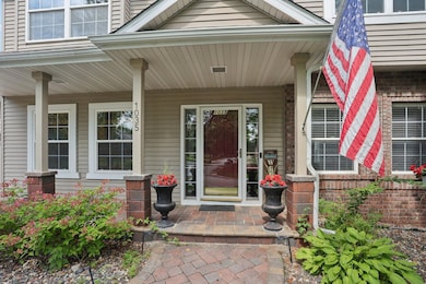


1035 Walnut Ridge Dr Saint Paul, MN 55123
Estimated payment $3,512/month
Highlights
- Deck
- No HOA
- Home Office
- Northview Elementary School Rated A-
- Game Room
- Stainless Steel Appliances
About This Home
Welcome to 1035 Walnut Ridge Drive, Eagan, MN—an exceptional, updated two-story home in one of Eagan’s most sought-after neighborhoods! This residence boasts a high-end kitchen perfect for culinary enthusiasts, four spacious bedrooms upstairs including a luxurious primary suite, and a main floor office ideal for remote work or study. Enjoy cozy evenings by the gas fireplace in the inviting family room, or entertain guests on the beautiful deck overlooking your landscaped yard. The three-car garage offers ample storage, and newer paver driveway, new roof (2023), while the paid-for solar panel system(2024) saves you hundreds of dollars on your monthly energy bill. EV charger in garage, and lawn sprinkler add modern convenience and efficiency. Step outside and you’re just a short walk to Cub Foods, Theresa’s Mexican Restaurant, Dunn Brothers Coffee, and a variety of local shops. Outdoor lovers will appreciate the proximity to Lebanon Hills Regional Park, offering miles of trails and natural beauty. Families will love being in the highly acclaimed ISD 196 Eagan school district. This home truly has it all—luxury, location, and lifestyle. Don’t miss your chance to make it yours! Schedule your private tour today.
Home Details
Home Type
- Single Family
Est. Annual Taxes
- $4,915
Year Built
- Built in 1997
Lot Details
- 10,498 Sq Ft Lot
- Lot Dimensions are 135x78
Parking
- 3 Car Attached Garage
- Driveway
Home Design
- Architectural Shingle Roof
Interior Spaces
- 2-Story Property
- Gas Fireplace
- Family Room with Fireplace
- Living Room
- Dining Room
- Home Office
- Game Room
Kitchen
- Range
- Dishwasher
- Stainless Steel Appliances
- The kitchen features windows
Bedrooms and Bathrooms
- 5 Bedrooms
Laundry
- Dryer
- Washer
Finished Basement
- Basement Fills Entire Space Under The House
- Drain
Outdoor Features
- Deck
Utilities
- Forced Air Heating and Cooling System
- Cable TV Available
Community Details
- No Home Owners Association
- Lexington Pointe 9Th Add Subdivision
Listing and Financial Details
- Assessor Parcel Number 104509301050
Map
Home Values in the Area
Average Home Value in this Area
Tax History
| Year | Tax Paid | Tax Assessment Tax Assessment Total Assessment is a certain percentage of the fair market value that is determined by local assessors to be the total taxable value of land and additions on the property. | Land | Improvement |
|---|---|---|---|---|
| 2024 | $5,266 | $477,400 | $123,100 | $354,300 |
| 2023 | $5,266 | $452,600 | $123,500 | $329,100 |
| 2022 | $4,306 | $453,300 | $123,100 | $330,200 |
| 2021 | $4,030 | $384,800 | $107,100 | $277,700 |
| 2020 | $4,110 | $353,500 | $102,000 | $251,500 |
| 2019 | $3,660 | $351,000 | $97,100 | $253,900 |
| 2018 | $3,906 | $331,100 | $92,500 | $238,600 |
| 2017 | $4,121 | $327,500 | $88,100 | $239,400 |
| 2016 | $4,204 | $329,400 | $83,900 | $245,500 |
| 2015 | $3,851 | $325,403 | $82,060 | $243,343 |
| 2014 | -- | $300,878 | $79,148 | $221,730 |
| 2013 | -- | $287,471 | $71,506 | $215,965 |
Property History
| Date | Event | Price | List to Sale | Price per Sq Ft |
|---|---|---|---|---|
| 11/13/2025 11/13/25 | Pending | -- | -- | -- |
| 11/04/2025 11/04/25 | Price Changed | $589,900 | -1.7% | $183 / Sq Ft |
| 10/15/2025 10/15/25 | Price Changed | $599,999 | -3.2% | $186 / Sq Ft |
| 09/05/2025 09/05/25 | For Sale | $619,900 | -- | $192 / Sq Ft |
Purchase History
| Date | Type | Sale Price | Title Company |
|---|---|---|---|
| Warranty Deed | $380,000 | -- | |
| Warranty Deed | $225,000 | -- | |
| Deed | $5,530 | -- | |
| Warranty Deed | $32,400 | -- |
Source: NorthstarMLS
MLS Number: 6780953
APN: 10-45093-01-050
Disclaimer: Certain information contained herein is derived from information provided by parties other than Homes.com. All information provided is deemed reliable, but is not guaranteed to be accurate and should be independently verified.
![]() Based on information submitted to the MLS GRID. All data is obtained from various sources and may not have been verified by broker or MLS GRID. Supplied Open House Information is subject to change without notice. All information should be independently reviewed and verified for accuracy. Properties may or may not be listed by the office/agent presenting the information. Some IDX listings have been excluded from this website.
Based on information submitted to the MLS GRID. All data is obtained from various sources and may not have been verified by broker or MLS GRID. Supplied Open House Information is subject to change without notice. All information should be independently reviewed and verified for accuracy. Properties may or may not be listed by the office/agent presenting the information. Some IDX listings have been excluded from this website.
The Digital Millennium Copyright Act of 1998, 17 U.S.C. § 512 (the “DMCA”) provides recourse for copyright owners who believe that material appearing on the Internet infringes their rights under U.S. copyright law. If you believe in good faith that any content or material made available in connection with our website or services infringes your copyright, you (or your agent) may send us a notice requesting that the content or material be removed, or access to it blocked.
Notices must be sent in writing by email to DMCAnotice@MLSGrid.com.
The DMCA requires that your notice of alleged copyright infringement include the following information:
(1) description of the copyrighted work that is the subject of claimed infringement;
(2) description of the alleged infringing content and information sufficient to permit us to locate the content;
(3) contact information for you, including your address, telephone number and email address;
(4) a statement by you that you have a good faith belief that the content in the manner complained of is not authorized by the copyright owner, or its agent, or by the operation of any law;
(5) a statement by you, signed under penalty of perjury, that the information in the notification is accurate and that you have the authority to enforce the copyrights that are claimed to be infringed; and
(6) a physical or electronic signature of the copyright owner or a person authorized to act on the copyright owner’s behalf. Failure to include all of the above information may result in the delay of the processing of your complaint.
- 973 Wildflower Ct
- 968 Coneflower Ct
- 1021 Diffley Rd
- 617 Remington Ct
- 935 Lakewood Hills Rd
- 4240 Braddock Trail
- 4081 Northview Terrace
- 4595 Horizon Cir
- 4575 Horizon Cir
- 4125 Pennsylvania Ave
- 782 Summerbrooke Ct
- 4124 New York Ave
- 1051 Northview Park Rd
- 1052 Ticonderoga Trail
- 886 Oak Ct
- 4027 Camberwell Dr N
- 1290 Deerwood Dr
- 4080 Camberwell Dr N
- 3989 Denmark Ave
- 1057 Kettle Creek Rd
