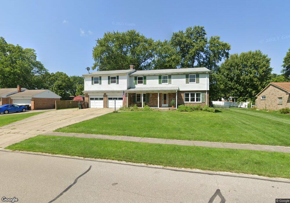
10375 Springrun Dr Cincinnati, OH 45231
New Burlington NeighborhoodEstimated Value: $313,000 - $413,000
5
Beds
3
Baths
2,756
Sq Ft
$127/Sq Ft
Est. Value
About This Home
This home is located at 10375 Springrun Dr, Cincinnati, OH 45231 and is currently estimated at $349,996, approximately $126 per square foot. 10375 Springrun Dr is a home located in Hamilton County with nearby schools including Mt Healthy High School, Hamilton County Mathematics and Science Academy, and Central Montessori Academy.
Ownership History
Date
Name
Owned For
Owner Type
Purchase Details
Closed on
Mar 20, 2021
Sold by
Lindner Ann J and Dorfmeyer Ann
Bought by
Lindner Ann J and Lindner Randy S
Current Estimated Value
Purchase Details
Closed on
Mar 8, 2021
Sold by
Estate Of Kevin Lindner
Bought by
Dorfmeyer Ann
Purchase Details
Closed on
Jul 22, 1996
Sold by
Lindner Kevin C
Bought by
Lindner Kevin C and Lindner Ann J
Home Financials for this Owner
Home Financials are based on the most recent Mortgage that was taken out on this home.
Original Mortgage
$127,500
Interest Rate
8.47%
Create a Home Valuation Report for This Property
The Home Valuation Report is an in-depth analysis detailing your home's value as well as a comparison with similar homes in the area
Home Values in the Area
Average Home Value in this Area
Purchase History
| Date | Buyer | Sale Price | Title Company |
|---|---|---|---|
| Lindner Ann J | -- | None Available | |
| Dorfmeyer Ann | -- | None Available | |
| Lindner Kevin C | -- | -- |
Source: Public Records
Mortgage History
| Date | Status | Borrower | Loan Amount |
|---|---|---|---|
| Previous Owner | Lindner Kevin C | $127,500 |
Source: Public Records
Tax History
| Year | Tax Paid | Tax Assessment Tax Assessment Total Assessment is a certain percentage of the fair market value that is determined by local assessors to be the total taxable value of land and additions on the property. | Land | Improvement |
|---|---|---|---|---|
| 2025 | $5,220 | $88,582 | $12,618 | $75,964 |
| 2023 | $4,918 | $88,582 | $12,618 | $75,964 |
| 2022 | $5,342 | $69,392 | $12,303 | $57,089 |
| 2021 | $5,201 | $69,392 | $12,303 | $57,089 |
| 2020 | $5,278 | $69,392 | $12,303 | $57,089 |
| 2019 | $4,457 | $54,639 | $9,688 | $44,951 |
| 2018 | $4,409 | $54,639 | $9,688 | $44,951 |
| 2017 | $4,183 | $54,639 | $9,688 | $44,951 |
| 2016 | $3,741 | $48,143 | $9,184 | $38,959 |
| 2015 | $3,770 | $48,143 | $9,184 | $38,959 |
| 2014 | $3,752 | $48,143 | $9,184 | $38,959 |
| 2013 | $4,035 | $52,906 | $10,094 | $42,812 |
Source: Public Records
Map
Nearby Homes
- 10453 Mill Rd
- 10493 Mill Rd
- 10228 Springbeauty Ln
- 1858 Aspenhill Dr
- 1887 Lotushill Dr
- 1958 Bluehill Dr
- 1931 Lotushill Dr
- 1854 Windmill Way
- 2192 Pinney Ln
- 1805 Miles Rd
- 2071 Roosevelt Ave
- 10908 Tangleberry Ct
- 624 Brightview Dr
- 626 Brightview Dr
- 606 Brightview Dr
- 610 Brightview Dr
- 622 Brightview Dr
- 614 Brightview Dr
- 616 Brightview Dr
- 620 Brightview Dr
- 10385 Springrun Dr Unit 36
- 10367 Springrun Dr
- 10378 Maria Ave
- 10384 Maria Ave
- 10372 Maria Ave
- 10378 Springrun Dr
- 10393 Springrun Dr
- 10388 Maria Ave
- 10386 Springrun Dr
- 1812 Springdale Rd
- 10357 Springrun Dr
- 10368 Maria Ave
- 10394 Maria Ave
- 10394 Springrun Dr
- 1770 Springdale Rd
- 10405 Springrun Dr
- 10400 Maria Ave
- 1830 Springdale Rd
- 10406 Springrun Dr
- 10379 Maria Ave
Your Personal Tour Guide
Ask me questions while you tour the home.