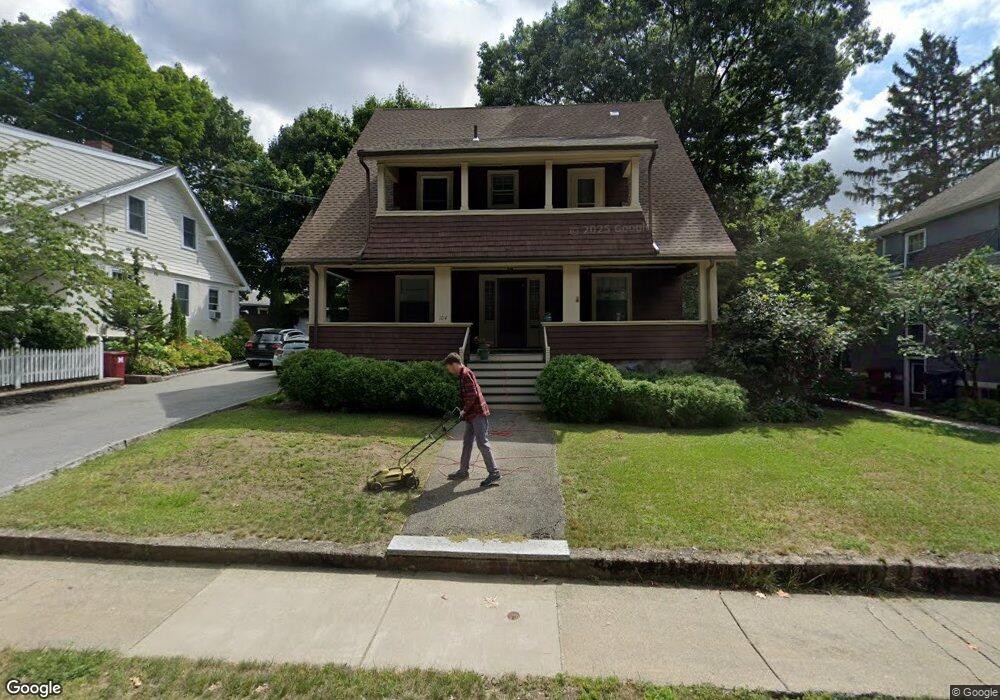
104 Warwick Rd Melrose, MA 02176
Melrose Highlands NeighborhoodEstimated Value: $928,190 - $1,089,000
4
Beds
2
Baths
1,918
Sq Ft
$529/Sq Ft
Est. Value
About This Home
This home is located at 104 Warwick Rd, Melrose, MA 02176 and is currently estimated at $1,013,798, approximately $528 per square foot. 104 Warwick Rd is a home located in Middlesex County with nearby schools including Roosevelt Elementary School, Horace Mann Elementary School, and Lincoln Elementary School.
Ownership History
Date
Name
Owned For
Owner Type
Purchase Details
Closed on
Jun 21, 2006
Sold by
Wiswell Daniel C
Bought by
Wiswell Kristi B
Current Estimated Value
Purchase Details
Closed on
Aug 15, 1991
Sold by
Tsui Mary E
Bought by
Wiswell Daniel C and Wiswell Kristi B
Purchase Details
Closed on
Jun 2, 1988
Sold by
Rose John R
Bought by
Tsui Philip W
Purchase Details
Closed on
Jun 12, 1987
Sold by
Stavro Thomas J
Bought by
Rose John R
Create a Home Valuation Report for This Property
The Home Valuation Report is an in-depth analysis detailing your home's value as well as a comparison with similar homes in the area
Home Values in the Area
Average Home Value in this Area
Purchase History
| Date | Buyer | Sale Price | Title Company |
|---|---|---|---|
| Wiswell Kristi B | -- | -- | |
| Wiswell Daniel C | $188,000 | -- | |
| Tsui Philip W | $221,000 | -- | |
| Rose John R | $210,000 | -- |
Source: Public Records
Mortgage History
| Date | Status | Borrower | Loan Amount |
|---|---|---|---|
| Open | Rose John R | $58,577 | |
| Closed | Rose John R | $25,000 | |
| Previous Owner | Rose John R | $300,000 |
Source: Public Records
Tax History
| Year | Tax Paid | Tax Assessment Tax Assessment Total Assessment is a certain percentage of the fair market value that is determined by local assessors to be the total taxable value of land and additions on the property. | Land | Improvement |
|---|---|---|---|---|
| 2025 | $76 | $769,100 | $456,000 | $313,100 |
| 2024 | $7,293 | $734,400 | $428,400 | $306,000 |
| 2023 | $7,317 | $702,200 | $414,600 | $287,600 |
| 2022 | $7,309 | $691,500 | $414,600 | $276,900 |
| 2021 | $7,121 | $650,300 | $386,900 | $263,400 |
| 2020 | $6,732 | $609,200 | $345,500 | $263,700 |
| 2019 | $6,071 | $561,600 | $319,200 | $242,400 |
| 2018 | $6,034 | $532,600 | $290,200 | $242,400 |
| 2017 | $5,849 | $495,700 | $276,400 | $219,300 |
| 2016 | $5,677 | $460,400 | $269,500 | $190,900 |
| 2015 | $5,469 | $422,000 | $241,800 | $180,200 |
| 2014 | $5,238 | $394,400 | $214,200 | $180,200 |
Source: Public Records
Map
Nearby Homes
- 35 Maple Rd
- 53 Perkins St
- 833 Franklin St
- 26 Poplar St
- 601 Franklin St Unit 2
- 62 Vinton St Unit 4
- 62 Maple St
- 6 Colby Terrace
- 24 Ellsworth Ave
- 23 Ellsworth Ave
- 43-51 Albion St Unit C9
- 300 Park Terrace Dr Unit 354
- 100 Park Terrace Dr Unit 106
- 37 S High St
- 49 Melrose St Unit 1F
- 51 Melrose St Unit 1C
- 51 Melrose St Unit 1A
- 177 Franklin St Unit 2
- 129 Greenwood St
- 33 Lake Ave
Your Personal Tour Guide
Ask me questions while you tour the home.