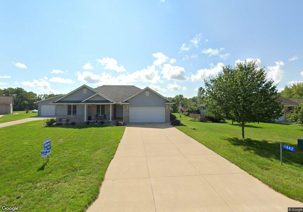
10442 202nd Ave Anamosa, IA 52205
Estimated Value: $412,816 - $465,000
4
Beds
3
Baths
1,500
Sq Ft
$287/Sq Ft
Est. Value
About This Home
This home is located at 10442 202nd Ave, Anamosa, IA 52205 and is currently estimated at $429,954, approximately $286 per square foot. 10442 202nd Ave is a home located in Jones County with nearby schools including Strawberry Hill Elementary School, Anamosa Middle School, and Anamosa High School.
Ownership History
Date
Name
Owned For
Owner Type
Purchase Details
Closed on
Oct 28, 2021
Sold by
Rathie Marvin L and Rathie Sandra D
Bought by
Remley Fred and Remley Amanda
Current Estimated Value
Home Financials for this Owner
Home Financials are based on the most recent Mortgage that was taken out on this home.
Original Mortgage
$272,000
Outstanding Balance
$248,039
Interest Rate
2.8%
Mortgage Type
New Conventional
Estimated Equity
$181,915
Create a Home Valuation Report for This Property
The Home Valuation Report is an in-depth analysis detailing your home's value as well as a comparison with similar homes in the area
Home Values in the Area
Average Home Value in this Area
Purchase History
| Date | Buyer | Sale Price | Title Company |
|---|---|---|---|
| Remley Fred | $340,000 | None Listed On Document |
Source: Public Records
Mortgage History
| Date | Status | Borrower | Loan Amount |
|---|---|---|---|
| Open | Remley Fred | $272,000 |
Source: Public Records
Tax History Compared to Growth
Tax History
| Year | Tax Paid | Tax Assessment Tax Assessment Total Assessment is a certain percentage of the fair market value that is determined by local assessors to be the total taxable value of land and additions on the property. | Land | Improvement |
|---|---|---|---|---|
| 2025 | $4,946 | $408,820 | $46,080 | $362,740 |
| 2024 | $4,946 | $391,190 | $46,080 | $345,110 |
| 2023 | $4,814 | $391,190 | $46,080 | $345,110 |
| 2022 | $4,118 | $297,790 | $43,010 | $254,780 |
| 2021 | $4,118 | $297,790 | $43,010 | $254,780 |
| 2020 | $3,760 | $264,550 | $43,010 | $221,540 |
| 2019 | $3,352 | $264,550 | $43,010 | $221,540 |
| 2018 | $3,174 | $228,700 | $26,420 | $202,280 |
| 2017 | $3,042 | $228,700 | $26,420 | $202,280 |
| 2016 | $2,978 | $216,970 | $26,420 | $190,550 |
| 2015 | $2,978 | $216,970 | $26,420 | $190,550 |
| 2014 | $2,950 | $206,900 | $23,680 | $183,220 |
| 2013 | $2,840 | $206,900 | $23,680 | $183,220 |
Source: Public Records
Map
Nearby Homes
- 128 Woodridge Rd
- 108 Wood Ridge Rd
- 915226002 Parcel, Lot 4 Wapsi Ridge
- 1108 E 3rd St
- 1611 Breca Ridge Dr Unit 4
- 1606 Breca Ridge Dr
- 108 E 5th St
- 608 S Garnavillo St
- 109 S Dubuque St
- 9174 207th Ave
- 1007 Maquoketa St
- 149 Country Club Ct
- 9071 207th Ave
- 103 N Oak St
- 433 Council St
- 205 S Ford St
- 435 Council St
- 105 N Division St
- 23083 County Road E34 Unit Lot 1
- 100 E 1st St
- 10458 202nd Ave
- 10426 202nd Ave
- 10428 202nd Ave
- 10470 202nd Ave
- 10489 202nd Ave
- 19994 Lead Mine Rd
- 10423 202nd Ave
- 10416 Shaw Rd Unit 10418
- 19990 Lead Mine Rd
- 10487 Shaw Rd
- 10282 Shaw Rd
- 10626 Shaw Rd
- 10160 Shaw Rd
- 19472 Lead Mine Rd
- 10084 Shaw Rd
- 10022 Shaw Rd
- 12481 227th Ave
- 11262 Highway 151
- 10085 Highway 151
- 10218 Deer Trail