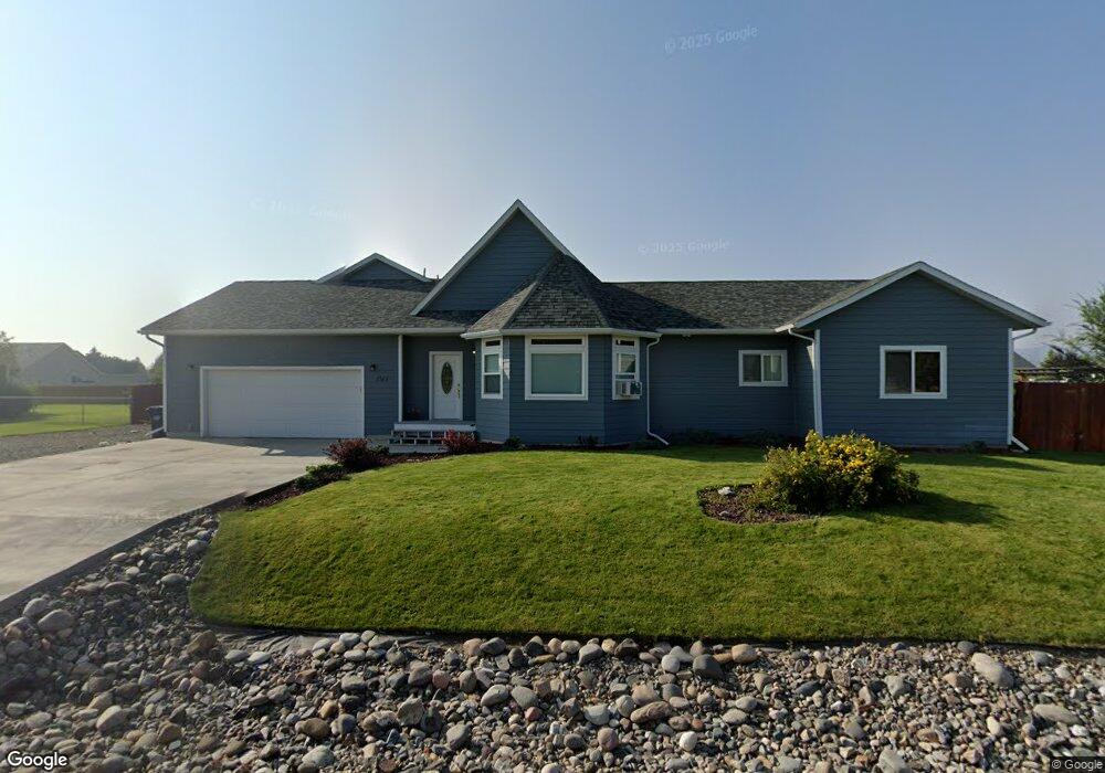
1045 Cap Rd Helena, MT 59602
West Helena Valley NeighborhoodEstimated Value: $481,605 - $537,000
3
Beds
2
Baths
1,568
Sq Ft
$319/Sq Ft
Est. Value
About This Home
This home is located at 1045 Cap Rd, Helena, MT 59602 and is currently estimated at $500,401, approximately $319 per square foot. 1045 Cap Rd is a home located in Lewis and Clark County with nearby schools including Four Georgians Elementary School, C.R. Anderson Middle School, and Calvary Christian School.
Ownership History
Date
Name
Owned For
Owner Type
Purchase Details
Closed on
Sep 17, 2012
Sold by
Heidlebaugh James A and Heidlebaugh Mary
Bought by
Leslie Robert and Leslie Sarah
Current Estimated Value
Purchase Details
Closed on
Nov 16, 2011
Sold by
Heidlebaugh Sarah K and Leslie Robert W
Bought by
Heidlebaugh James A and Heidlebaugh Mary
Home Financials for this Owner
Home Financials are based on the most recent Mortgage that was taken out on this home.
Original Mortgage
$152,500
Interest Rate
3.87%
Mortgage Type
New Conventional
Purchase Details
Closed on
May 31, 2011
Sold by
Bryant Land Development Llc
Bought by
Heidlebaugh James A and Heidlebaugh Mary
Home Financials for this Owner
Home Financials are based on the most recent Mortgage that was taken out on this home.
Original Mortgage
$163,897
Interest Rate
4.73%
Mortgage Type
Construction
Create a Home Valuation Report for This Property
The Home Valuation Report is an in-depth analysis detailing your home's value as well as a comparison with similar homes in the area
Home Values in the Area
Average Home Value in this Area
Purchase History
| Date | Buyer | Sale Price | Title Company |
|---|---|---|---|
| Leslie Robert | -- | Chicago Title Company | |
| Heidlebaugh James A | -- | Chicago Title Company | |
| Heidlebaugh James A | -- | First Mt Title Co Of Helena |
Source: Public Records
Mortgage History
| Date | Status | Borrower | Loan Amount |
|---|---|---|---|
| Previous Owner | Heidlebaugh James A | $152,500 | |
| Previous Owner | Heidlebaugh James A | $163,897 |
Source: Public Records
Tax History Compared to Growth
Tax History
| Year | Tax Paid | Tax Assessment Tax Assessment Total Assessment is a certain percentage of the fair market value that is determined by local assessors to be the total taxable value of land and additions on the property. | Land | Improvement |
|---|---|---|---|---|
| 2025 | $2,290 | $475,700 | $0 | $0 |
| 2024 | $3,389 | $412,500 | $0 | $0 |
| 2023 | $3,535 | $412,500 | $0 | $0 |
| 2022 | $2,967 | $291,400 | $0 | $0 |
| 2021 | $2,786 | $291,400 | $0 | $0 |
| 2020 | $2,684 | $257,600 | $0 | $0 |
| 2019 | $2,705 | $257,600 | $0 | $0 |
| 2018 | $2,488 | $232,700 | $0 | $0 |
| 2017 | $2,003 | $232,700 | $0 | $0 |
| 2016 | $2,035 | $222,900 | $0 | $0 |
| 2015 | $1,320 | $222,900 | $0 | $0 |
| 2014 | $1,360 | $124,073 | $0 | $0 |
Source: Public Records
Map
Nearby Homes
- 1030 Motsiff Rd
- 1010 Motsiff Rd
- 4435 Woodchuck Dr
- 4506 Porcupine Dr
- 4350 N Montana Ave Unit 5
- 4324 N Montana Ave
- 630 Stadler Rd
- 5530 N Montana Ave
- 5288 Glacier Point Loop
- 5277 Glacier Point Loop
- 1344 Beaverhead Rd
- 1650 Karmen Rd
- 3960 Canal Dr
- 5420 Robin Dr
- 835 Onyx Place
- 1698 Kelly Rd
- 845 Faw Rd
- 3570 Juniper Dr
- 1325 Cambray Loop
- 3859 Timothy Ln
- 1045 Cap Rd Unit Lot 33 Bryant No. 3
- 1065 Cap Rd
- 1065 Cap Rd Unit Lot 34 Bryant No. 3
- 1025 Cap Rd
- 1025 Cap Rd Unit Lot 32 Bryant No. 3
- 1040 Cap Rd
- 1030 Isy Loop
- 1050 Isy Loop
- 1020 Cap Rd
- 1060 Cap Rd
- 985 Cap Rd
- 985 Cap Rd Unit Lot 31 Bryant No. 3
- 1085 Cap Rd
- 1085 Cap Rd Unit Lot 35 Bryant No. 3
- 1080 Cap Rd
- 1070 Isy Loop
- 980 Cap Rd
- 1031 Motsiff Rd
- 1015 Motsiff Rd
- 1061 Motsiff Rd