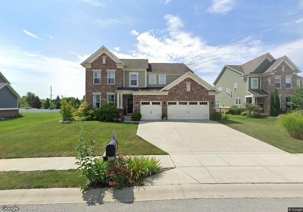
10467 Cleary Trace Dr Fishers, IN 46040
Brooks-Luxhaven NeighborhoodEstimated Value: $595,589 - $632,000
3
Beds
3
Baths
2,788
Sq Ft
$221/Sq Ft
Est. Value
About This Home
This home is located at 10467 Cleary Trace Dr, Fishers, IN 46040 and is currently estimated at $616,397, approximately $221 per square foot. 10467 Cleary Trace Dr is a home with nearby schools including Southeastern Elementary School, Hamilton Southeastern Intermediate / Junior High, and Hamilton Southeastern High School.
Ownership History
Date
Name
Owned For
Owner Type
Purchase Details
Closed on
Jun 25, 2015
Sold by
Rh Of Indiana Lp
Bought by
Myers Mark A and Myers Rebecca A
Current Estimated Value
Home Financials for this Owner
Home Financials are based on the most recent Mortgage that was taken out on this home.
Original Mortgage
$334,144
Outstanding Balance
$259,448
Interest Rate
3.82%
Mortgage Type
New Conventional
Estimated Equity
$356,949
Purchase Details
Closed on
Jan 26, 2015
Sold by
Mrb Development Llc
Bought by
Rh Of Indiana Lp
Create a Home Valuation Report for This Property
The Home Valuation Report is an in-depth analysis detailing your home's value as well as a comparison with similar homes in the area
Home Values in the Area
Average Home Value in this Area
Purchase History
| Date | Buyer | Sale Price | Title Company |
|---|---|---|---|
| Myers Mark A | -- | Attorney | |
| Rh Of Indiana Lp | -- | None Available |
Source: Public Records
Mortgage History
| Date | Status | Borrower | Loan Amount |
|---|---|---|---|
| Open | Myers Mark A | $334,144 |
Source: Public Records
Tax History Compared to Growth
Tax History
| Year | Tax Paid | Tax Assessment Tax Assessment Total Assessment is a certain percentage of the fair market value that is determined by local assessors to be the total taxable value of land and additions on the property. | Land | Improvement |
|---|---|---|---|---|
| 2024 | $5,348 | $483,900 | $79,000 | $404,900 |
| 2023 | $5,348 | $462,500 | $79,000 | $383,500 |
| 2022 | $4,871 | $408,800 | $79,000 | $329,800 |
| 2021 | $4,507 | $375,500 | $89,000 | $286,500 |
| 2020 | $4,347 | $361,200 | $89,000 | $272,200 |
| 2019 | $4,153 | $345,500 | $68,400 | $277,100 |
| 2018 | $4,138 | $343,400 | $68,400 | $275,000 |
| 2017 | $3,897 | $329,300 | $76,900 | $252,400 |
| 2016 | $3,958 | $334,500 | $76,900 | $257,600 |
| 2014 | $13 | $600 | $600 | $0 |
Source: Public Records
Map
Nearby Homes
- 10473 Ranford Blvd
- 10504 Ruxton Ct
- 10389 Blue Ribbon Blvd
- 10198 Ranford Blvd
- 15628 Provincial Ln
- 10166 Ranford Blvd
- 15303 Ackerley Dr
- 14940 Tiago Ln
- 9968 Midnight Line Dr
- 10671 Geist Ridge Ct
- 9927 Midnight Line Dr
- 9889 Gallop Ln
- 10544 Tavarez Ct
- 9901 Copper Saddle Bend
- 15970 Noble Fir Ct
- 14476 Faucet Ln
- 4077 Murray Dr
- 9925 Hyde Dr
- 4091 Murray Dr
- Mackey II Plan at Helm's Mill
- 10467 Cleary Trace Dr
- 10459 Cleary Trace Dr
- 10475 Cleary Trace Dr
- 10451 Cleary Trace Dr
- 10474 Cleary Trace Dr
- 10466 Cleary Trace Dr
- 10458 Cleary Trace Dr
- 15349 Dorman Ct
- 10450 Cleary Trace Dr
- 10482 Cleary Trace Dr
- 10479 Cleary Trace Dr
- 15363 Dorman Ct
- 10483 Cleary Trace Dr
- 15313 Ellington Dr
- 15295 Ellington Dr
- 15377 Dorman Ct
- 15277 Ellington Dr
- 10491 Cleary Trace Dr
- 15259 Ellington Dr
- 15392 Dorman Ct