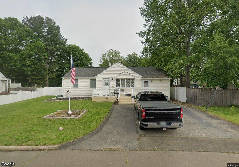
105 Ruby Rd West Haven, CT 06516
West Shore NeighborhoodEstimated Value: $406,000 - $465,999
3
Beds
3
Baths
1,760
Sq Ft
$245/Sq Ft
Est. Value
About This Home
This home is located at 105 Ruby Rd, West Haven, CT 06516 and is currently estimated at $432,000, approximately $245 per square foot. 105 Ruby Rd is a home located in New Haven County with nearby schools including Carrigan 5/6 Intermediate School, Harry M. Bailey Middle School, and West Haven High School.
Ownership History
Date
Name
Owned For
Owner Type
Purchase Details
Closed on
Mar 9, 2021
Sold by
Pacapelli Eugene and Pacapelli Lynda
Bought by
Pacapelli Eugene and Pacapelli Lynda
Current Estimated Value
Purchase Details
Closed on
Aug 4, 1998
Sold by
Brown Thomas P and Brown Paula T
Bought by
Pacapelli Michael
Home Financials for this Owner
Home Financials are based on the most recent Mortgage that was taken out on this home.
Original Mortgage
$121,600
Interest Rate
6.92%
Mortgage Type
Unknown
Purchase Details
Closed on
Oct 31, 1989
Sold by
Pope Richard
Bought by
Brown Thomas P
Create a Home Valuation Report for This Property
The Home Valuation Report is an in-depth analysis detailing your home's value as well as a comparison with similar homes in the area
Home Values in the Area
Average Home Value in this Area
Purchase History
| Date | Buyer | Sale Price | Title Company |
|---|---|---|---|
| Pacapelli Eugene | -- | None Available | |
| Pacapelli Michael | $128,000 | -- | |
| Brown Thomas P | $168,000 | -- |
Source: Public Records
Mortgage History
| Date | Status | Borrower | Loan Amount |
|---|---|---|---|
| Previous Owner | Brown Thomas P | $93,000 | |
| Previous Owner | Brown Thomas P | $115,000 | |
| Previous Owner | Brown Thomas P | $121,600 | |
| Previous Owner | Brown Thomas P | $93,000 |
Source: Public Records
Tax History
| Year | Tax Paid | Tax Assessment Tax Assessment Total Assessment is a certain percentage of the fair market value that is determined by local assessors to be the total taxable value of land and additions on the property. | Land | Improvement |
|---|---|---|---|---|
| 2025 | $8,580 | $261,030 | $88,970 | $172,060 |
| 2024 | $8,056 | $171,920 | $61,600 | $110,320 |
| 2023 | $7,754 | $171,920 | $61,600 | $110,320 |
| 2022 | $7,614 | $171,920 | $61,600 | $110,320 |
| 2021 | $7,614 | $171,920 | $61,600 | $110,320 |
| 2020 | $7,656 | $157,500 | $57,540 | $99,960 |
| 2019 | $7,412 | $157,500 | $57,540 | $99,960 |
| 2018 | $7,306 | $157,500 | $57,540 | $99,960 |
| 2017 | $7,110 | $157,500 | $57,540 | $99,960 |
| 2016 | $6,990 | $156,590 | $57,540 | $99,050 |
| 2015 | $6,733 | $168,840 | $61,320 | $107,520 |
| 2014 | $6,733 | $168,840 | $61,320 | $107,520 |
Source: Public Records
Map
Nearby Homes