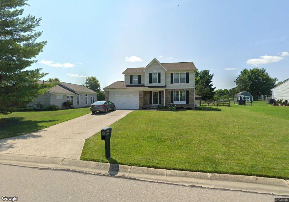
10500 Springrun Dr Cincinnati, OH 45231
New Burlington NeighborhoodEstimated Value: $285,000 - $330,000
4
Beds
3
Baths
1,716
Sq Ft
$182/Sq Ft
Est. Value
About This Home
This home is located at 10500 Springrun Dr, Cincinnati, OH 45231 and is currently estimated at $311,718, approximately $181 per square foot. 10500 Springrun Dr is a home located in Hamilton County with nearby schools including Mt Healthy High School, Hamilton County Mathematics and Science Academy, and Central Montessori Academy.
Ownership History
Date
Name
Owned For
Owner Type
Purchase Details
Closed on
Jan 12, 1994
Sold by
The Ryland Group Inc
Bought by
Shields Paris Edward and Shields Susan Lee
Current Estimated Value
Home Financials for this Owner
Home Financials are based on the most recent Mortgage that was taken out on this home.
Original Mortgage
$112,450
Interest Rate
7.26%
Create a Home Valuation Report for This Property
The Home Valuation Report is an in-depth analysis detailing your home's value as well as a comparison with similar homes in the area
Home Values in the Area
Average Home Value in this Area
Purchase History
| Date | Buyer | Sale Price | Title Company |
|---|---|---|---|
| Shields Paris Edward | -- | -- |
Source: Public Records
Mortgage History
| Date | Status | Borrower | Loan Amount |
|---|---|---|---|
| Closed | Shields Paris Edward | $112,450 |
Source: Public Records
Tax History
| Year | Tax Paid | Tax Assessment Tax Assessment Total Assessment is a certain percentage of the fair market value that is determined by local assessors to be the total taxable value of land and additions on the property. | Land | Improvement |
|---|---|---|---|---|
| 2025 | $4,960 | $84,074 | $13,153 | $70,921 |
| 2023 | $4,673 | $84,074 | $13,153 | $70,921 |
| 2022 | $5,305 | $68,901 | $12,824 | $56,077 |
| 2021 | $5,165 | $68,901 | $12,824 | $56,077 |
| 2020 | $5,241 | $68,901 | $12,824 | $56,077 |
| 2019 | $4,427 | $54,254 | $10,098 | $44,156 |
| 2018 | $4,379 | $54,254 | $10,098 | $44,156 |
| 2017 | $4,154 | $54,254 | $10,098 | $44,156 |
| 2016 | $3,947 | $50,792 | $9,576 | $41,216 |
| 2015 | $3,977 | $50,792 | $9,576 | $41,216 |
| 2014 | $3,959 | $50,792 | $9,576 | $41,216 |
| 2013 | $4,256 | $55,819 | $10,525 | $45,294 |
Source: Public Records
Map
Nearby Homes
- 10493 Mill Rd
- 10453 Mill Rd
- 1858 Aspenhill Dr
- 1887 Lotushill Dr
- 1854 Windmill Way
- 1931 Lotushill Dr
- 1958 Bluehill Dr
- 10908 Tangleberry Ct
- 10228 Springbeauty Ln
- 10945 Crystalhill Ct
- 2071 Roosevelt Ave
- 2192 Pinney Ln
- 23 Briarwood Ln
- 10877 Birchridge Dr
- 10897 Sprucehill Dr
- 1805 Miles Rd
- 2342 Washington Ave
- 10474 Gloria Ave
- 2456 Fulbourne Dr
- 624 Brightview Dr
- 10589 Mill Farm Ct
- 10494 Springrun Dr
- 10581 Mill Farm Ct
- 10584 Farm Hill Ct
- 10490 Springrun Dr
- 10569 Mill Farm Ct
- 10501 Springrun Dr
- 10495 Springrun Dr
- 10507 Springrun Dr
- 10576 Farm Hill Ct
- 10491 Springrun Dr
- 10563 Mill Farm Ct
- 10594 Mill Farm Ct
- 10586 Mill Farm Ct
- 10513 Springrun Dr
- 10580 Mill Farm Ct
- 10485 Springrun Dr
- 10480 Springrun Dr
- 10574 Mill Farm Ct
- 10572 Farm Hill Ct
Your Personal Tour Guide
Ask me questions while you tour the home.