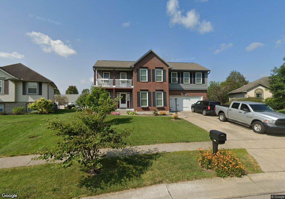
1055 Colonial Cir Lebanon, OH 45036
Estimated Value: $371,899 - $422,000
3
Beds
3
Baths
2,064
Sq Ft
$192/Sq Ft
Est. Value
About This Home
This home is located at 1055 Colonial Cir, Lebanon, OH 45036 and is currently estimated at $395,475, approximately $191 per square foot. 1055 Colonial Cir is a home located in Warren County with nearby schools including Bowman Primary School, Berry Intermediate School, and Donovan Elementary School.
Ownership History
Date
Name
Owned For
Owner Type
Purchase Details
Closed on
Oct 11, 2000
Sold by
Oberer Res Const Ltd
Bought by
Kuntz Barry A and Kuntz Rhonda L
Current Estimated Value
Home Financials for this Owner
Home Financials are based on the most recent Mortgage that was taken out on this home.
Original Mortgage
$124,400
Outstanding Balance
$45,724
Interest Rate
8.03%
Mortgage Type
New Conventional
Estimated Equity
$349,751
Purchase Details
Closed on
Apr 17, 2000
Sold by
Oberer Dev Co
Bought by
Oberer Residential Const Ltd
Create a Home Valuation Report for This Property
The Home Valuation Report is an in-depth analysis detailing your home's value as well as a comparison with similar homes in the area
Home Values in the Area
Average Home Value in this Area
Purchase History
| Date | Buyer | Sale Price | Title Company |
|---|---|---|---|
| Kuntz Barry A | $164,900 | -- | |
| Oberer Residential Const Ltd | $93,500 | -- |
Source: Public Records
Mortgage History
| Date | Status | Borrower | Loan Amount |
|---|---|---|---|
| Open | Kuntz Barry A | $124,400 |
Source: Public Records
Tax History Compared to Growth
Tax History
| Year | Tax Paid | Tax Assessment Tax Assessment Total Assessment is a certain percentage of the fair market value that is determined by local assessors to be the total taxable value of land and additions on the property. | Land | Improvement |
|---|---|---|---|---|
| 2024 | $4,661 | $112,170 | $28,000 | $84,170 |
| 2023 | $4,099 | $88,585 | $12,915 | $75,670 |
| 2022 | $4,272 | $88,585 | $12,915 | $75,670 |
| 2021 | $4,037 | $88,585 | $12,915 | $75,670 |
| 2020 | $3,886 | $72,020 | $10,500 | $61,520 |
| 2019 | $3,707 | $68,450 | $10,500 | $57,950 |
| 2018 | $3,177 | $68,450 | $10,500 | $57,950 |
| 2017 | $3,317 | $64,120 | $10,423 | $53,697 |
| 2016 | $3,422 | $64,120 | $10,423 | $53,697 |
| 2015 | $3,447 | $64,120 | $10,423 | $53,697 |
| 2014 | $3,263 | $58,290 | $9,470 | $48,810 |
| 2013 | $3,139 | $64,590 | $10,500 | $54,090 |
Source: Public Records
Map
Nearby Homes
- 278 Ludlow Ct
- 1130 Silversmith Way
- 364 Grey's Run
- 351 Grey's Run
- 376 Grey's Run
- 1133 Reveres Run
- 1179 Silversmith Way
- 1644 Cantebury Ln
- 243 Birmingham Ct
- 382 N Church Dr
- 5 Acres Lot D Phillips Rd
- 409 Bethpage Way Unit 7-301
- 5 Acres Ave
- 409 Bethpage Way
- 229 Dickens Ct
- 1443 N Broadway St
- 1 Dryhill Ct
- 908 Hartz Dr
- 660 Carson Dr
- 764 Lake Bluff (Lot 1) Ct
- 1059 Colonial Cir
- 1051 Colonial Cir
- 1044 Reveres Run
- 1040 Reveres Run
- 1048 Reveres Run
- 1063 Colonial Cir
- 1047 Colonial Cir
- 1054 Colonial Cir
- 1036 Reveres Run
- 1052 Reveres Run
- 1064 Colonial Cir
- 1067 Colonial Cir
- 1032 Revere's Run
- 1057 Heritage Trace
- 1056 Reveres Run
- 1049 Heritage Trace
- 1037 Heritage Trace
- 1061 Heritage Trace
- 501 Clarion Ct
- 1041 Heritage Trace