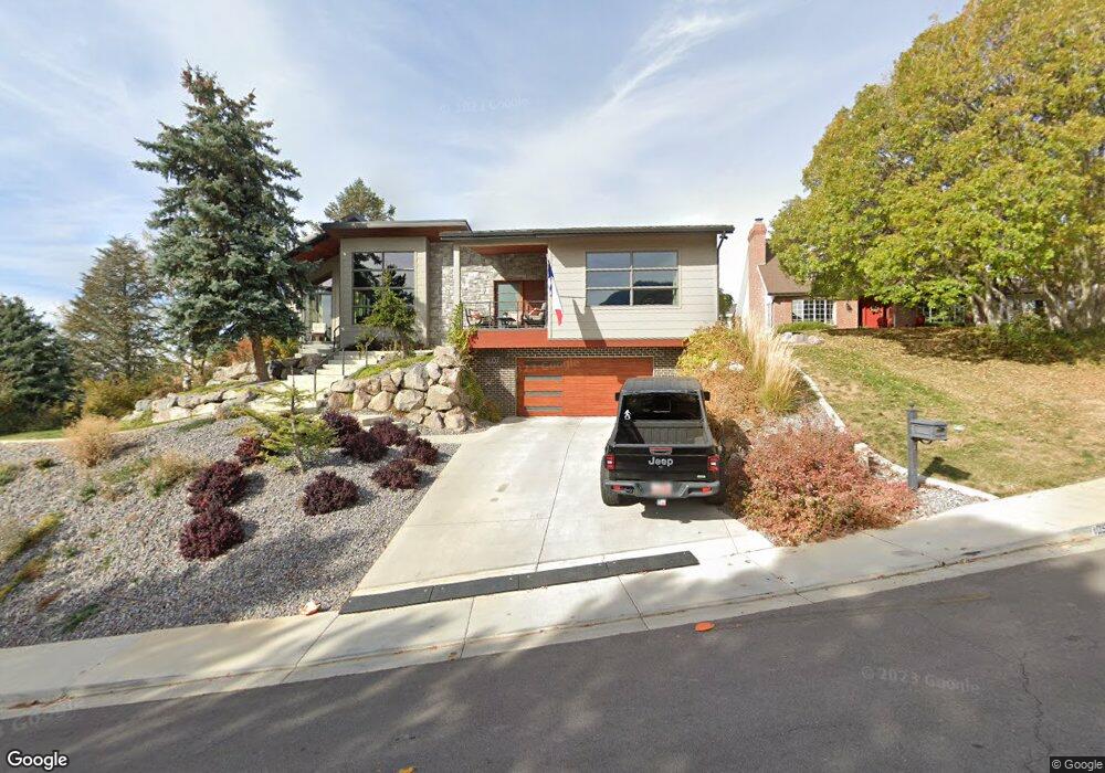
1057 Windsor Dr Provo, UT 84604
Rock Canyon NeighborhoodEstimated Value: $930,000 - $1,207,000
3
Beds
3
Baths
3,440
Sq Ft
$319/Sq Ft
Est. Value
About This Home
This home is located at 1057 Windsor Dr, Provo, UT 84604 and is currently estimated at $1,098,313, approximately $319 per square foot. 1057 Windsor Dr is a home located in Utah County with nearby schools including Canyon Crest Elementary School, Centennial Middle School, and Timpview High School.
Ownership History
Date
Name
Owned For
Owner Type
Purchase Details
Closed on
May 5, 2022
Sold by
Teresa Fae Wade Family Trust
Bought by
Britt And Lori Berrett Trust
Current Estimated Value
Purchase Details
Closed on
Mar 10, 2022
Sold by
Kenneth J Wade Trust
Bought by
Teresa Fae Wade Family Trust
Purchase Details
Closed on
Feb 21, 2020
Sold by
Wade Kenneth J and Wade Teresa F
Bought by
Wade Kenneth J and The Kenneth J Wade Trust
Home Financials for this Owner
Home Financials are based on the most recent Mortgage that was taken out on this home.
Original Mortgage
$161,500
Interest Rate
3.6%
Mortgage Type
New Conventional
Create a Home Valuation Report for This Property
The Home Valuation Report is an in-depth analysis detailing your home's value as well as a comparison with similar homes in the area
Home Values in the Area
Average Home Value in this Area
Purchase History
| Date | Buyer | Sale Price | Title Company |
|---|---|---|---|
| Britt And Lori Berrett Trust | -- | New Title Company Name | |
| Teresa Fae Wade Family Trust | -- | None Listed On Document | |
| Wade Kenneth J | -- | Pro Title & Escrow Inc | |
| Wade Kenneth J | -- | Pro Title & Escrow Inc |
Source: Public Records
Mortgage History
| Date | Status | Borrower | Loan Amount |
|---|---|---|---|
| Previous Owner | Wade Kenneth J | $161,500 |
Source: Public Records
Tax History
| Year | Tax Paid | Tax Assessment Tax Assessment Total Assessment is a certain percentage of the fair market value that is determined by local assessors to be the total taxable value of land and additions on the property. | Land | Improvement |
|---|---|---|---|---|
| 2025 | $4,730 | $476,905 | -- | -- |
| 2024 | $4,730 | $465,575 | $0 | $0 |
| 2023 | $4,832 | $468,930 | $0 | $0 |
| 2022 | $4,651 | $455,125 | $0 | $0 |
| 2021 | $3,698 | $631,100 | $205,400 | $425,700 |
| 2020 | $3,679 | $588,600 | $171,200 | $417,400 |
Source: Public Records
Map
Nearby Homes
- 1085 Windsor Dr
- 4640 Brookshire Cir
- 924 Redford Dr
- 4299 Ivy Ln
- 4601 Foothill Dr
- 981 Waterford Dr Unit 5&6
- 3943 Foothill Dr
- 645 Foothill Dr
- 285 Three Fountains Dr
- 221 E 4735 N
- 144 E 4620 N
- 4161 N Canyon Rd Unit 2
- 3702 N 920 E
- 3726 Devonshire Dr
- 299 E 4000 N
- 407 E 3900 Rd N Unit 1
- 407 E 3900 Rd N
- 5005 N Edgewood Dr Unit 310
- 3711 N Canyon Rd
- 3442 Navajo Ln
- 1057 Windsor Dr Unit 170
- 1057 Windsor Dr Unit 170
- 1071 Windsor Dr
- 4621 Bristol Cir
- 1037 Windsor Dr
- 1068 Windsor Dr
- 1040 Windsor Dr
- 1029 Windsor Dr
- 4612 N Bristol Cir
- 4551 N Victoria Cir Unit 159
- 4573 N Victoria Cir Unit 158
- 1028 Hillside Dr
- 4612 Bristol Cir
- 1082 Windsor Dr
- 4594 Victoria Cir
- 1022 Windsor Dr
- 1094 Windsor Dr
- 1022 Hillside Dr Unit 233
- 4540 Bristol Cir
- 1002 Hillside Dr
Your Personal Tour Guide
Ask me questions while you tour the home.