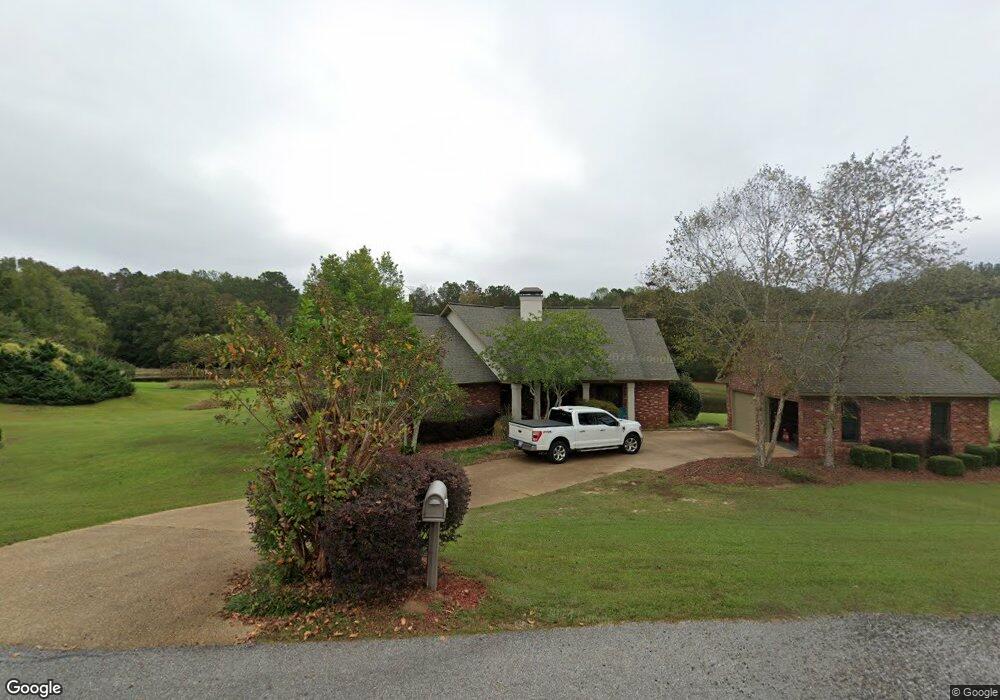
106 Daniels Cove Philadelphia, MS 39350
Estimated Value: $72,000 - $276,368
--
Bed
2
Baths
2,037
Sq Ft
$93/Sq Ft
Est. Value
About This Home
This home is located at 106 Daniels Cove, Philadelphia, MS 39350 and is currently estimated at $190,342, approximately $93 per square foot. 106 Daniels Cove is a home located in Neshoba County.
Ownership History
Date
Name
Owned For
Owner Type
Purchase Details
Closed on
Apr 28, 2020
Sold by
White Sheena and White Chad
Bought by
Skinner Jonathan and Skinner Diana
Current Estimated Value
Home Financials for this Owner
Home Financials are based on the most recent Mortgage that was taken out on this home.
Original Mortgage
$165,600
Outstanding Balance
$146,423
Interest Rate
3.3%
Mortgage Type
New Conventional
Estimated Equity
$43,919
Purchase Details
Closed on
Jun 13, 2016
Sold by
Renfrow Dustin G and Renfrow Lindsy D
Bought by
White Chad
Purchase Details
Closed on
Jun 25, 2007
Sold by
Eubanks Mick and Eubanks Allison S
Bought by
Merriman Bruce R and Merriman Mary B
Home Financials for this Owner
Home Financials are based on the most recent Mortgage that was taken out on this home.
Original Mortgage
$100,000
Interest Rate
6.35%
Mortgage Type
Purchase Money Mortgage
Create a Home Valuation Report for This Property
The Home Valuation Report is an in-depth analysis detailing your home's value as well as a comparison with similar homes in the area
Home Values in the Area
Average Home Value in this Area
Purchase History
| Date | Buyer | Sale Price | Title Company |
|---|---|---|---|
| Skinner Jonathan | -- | -- | |
| White Chad | -- | -- | |
| Merriman Bruce R | -- | -- |
Source: Public Records
Mortgage History
| Date | Status | Borrower | Loan Amount |
|---|---|---|---|
| Open | Skinner Jonathan | $165,600 | |
| Previous Owner | Merriman Bruce R | $100,000 |
Source: Public Records
Tax History Compared to Growth
Tax History
| Year | Tax Paid | Tax Assessment Tax Assessment Total Assessment is a certain percentage of the fair market value that is determined by local assessors to be the total taxable value of land and additions on the property. | Land | Improvement |
|---|---|---|---|---|
| 2025 | $1,947 | $20,933 | $0 | $0 |
| 2024 | $1,947 | $20,914 | $0 | $0 |
| 2023 | $1,822 | $19,162 | $0 | $0 |
| 2022 | $1,822 | $19,162 | $0 | $0 |
| 2021 | $1,826 | $19,162 | $0 | $0 |
| 2020 | $1,786 | $19,162 | $0 | $0 |
| 2019 | $1,718 | $18,450 | $0 | $0 |
| 2018 | $2,018 | $18,450 | $0 | $0 |
| 2017 | $2,969 | $27,675 | $0 | $0 |
| 2016 | $1,687 | $18,450 | $0 | $0 |
| 2015 | -- | $18,309 | $0 | $0 |
| 2014 | -- | $18,309 | $0 | $0 |
Source: Public Records
Map
Nearby Homes
- 0 Dogwood Ln
- 10800 Highway 16 E
- 0 Mississippi 486
- 0 County Road 545
- 130 Air Park Dr
- 11680 Road 539
- 0 E Myrtle St
- 519 Welch St
- 551 State Ave
- 553 State Ave
- 0 State Ave
- 531 State Ave
- 558 Holland Ave
- 521 Holland Ave
- 517 Holland Ave
- 554 Poplar Ave
- 408 Hospital St
- 507 Poplar Ave
- 0 Columbus Ave
- 507 Dorothy St