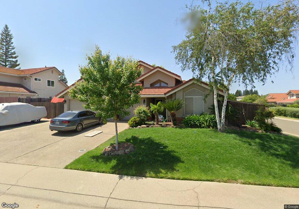
106 Heaton Way Folsom, CA 95630
Broadstone NeighborhoodEstimated Value: $671,196 - $727,000
3
Beds
2
Baths
1,608
Sq Ft
$441/Sq Ft
Est. Value
About This Home
This home is located at 106 Heaton Way, Folsom, CA 95630 and is currently estimated at $709,049, approximately $440 per square foot. 106 Heaton Way is a home located in Sacramento County with nearby schools including Gold Ridge Elementary School, Sutter Middle School, and Folsom High School.
Ownership History
Date
Name
Owned For
Owner Type
Purchase Details
Closed on
Apr 9, 2025
Sold by
Kraft Stacie and Kraft Kevin
Bought by
Kraft Family Trust and Kraft
Current Estimated Value
Purchase Details
Closed on
Aug 19, 2001
Sold by
Kuzinich Peter A and Kuzinich Josephine T
Bought by
Kraft Kevin and Kraft Stacie
Home Financials for this Owner
Home Financials are based on the most recent Mortgage that was taken out on this home.
Original Mortgage
$212,400
Interest Rate
7.09%
Create a Home Valuation Report for This Property
The Home Valuation Report is an in-depth analysis detailing your home's value as well as a comparison with similar homes in the area
Home Values in the Area
Average Home Value in this Area
Purchase History
| Date | Buyer | Sale Price | Title Company |
|---|---|---|---|
| Kraft Family Trust | -- | None Listed On Document | |
| Kraft Family Trust | -- | None Listed On Document | |
| Kraft Kevin | $265,500 | Stewart Title |
Source: Public Records
Mortgage History
| Date | Status | Borrower | Loan Amount |
|---|---|---|---|
| Previous Owner | Kraft Kevin | $212,400 | |
| Closed | Kraft Kevin | $26,550 |
Source: Public Records
Tax History Compared to Growth
Tax History
| Year | Tax Paid | Tax Assessment Tax Assessment Total Assessment is a certain percentage of the fair market value that is determined by local assessors to be the total taxable value of land and additions on the property. | Land | Improvement |
|---|---|---|---|---|
| 2025 | $4,321 | $392,199 | $118,172 | $274,027 |
| 2024 | $4,321 | $384,509 | $115,855 | $268,654 |
| 2023 | $4,245 | $376,971 | $113,584 | $263,387 |
| 2022 | $4,184 | $369,580 | $111,357 | $258,223 |
| 2021 | $4,128 | $362,334 | $109,174 | $253,160 |
| 2020 | $4,078 | $358,620 | $108,055 | $250,565 |
| 2019 | $4,104 | $351,589 | $105,937 | $245,652 |
| 2018 | $4,008 | $344,696 | $103,860 | $240,836 |
| 2017 | $3,757 | $337,938 | $101,824 | $236,114 |
| 2016 | $4,271 | $331,313 | $99,828 | $231,485 |
| 2015 | $4,281 | $326,337 | $98,329 | $228,008 |
| 2014 | $4,013 | $319,945 | $96,403 | $223,542 |
Source: Public Records
Map
Nearby Homes
- 757 Hatherden Ct
- 408-408 1/2 Reading St
- 616-616 1/2 Mormon St
- 1205 Albrighton Dr
- 102 Black Gold Ln
- 646 Cullingworth Ct
- 104 Hesser Ct
- 0 Figueroa St Unit 225034113
- 101 Duxbury Way
- 415 S Lexington Dr
- 108 Bloomfield Way
- 2142 Haverhill Dr
- 1118 Buckbrush Dr
- 128 Mesquite Ct
- 429 N Lexington Dr
- 718 Hunter Place
- 103 Grenoble Way
- 102 Grenoble Way
- 511 Heiler Ct
- 380 Gardner Ct