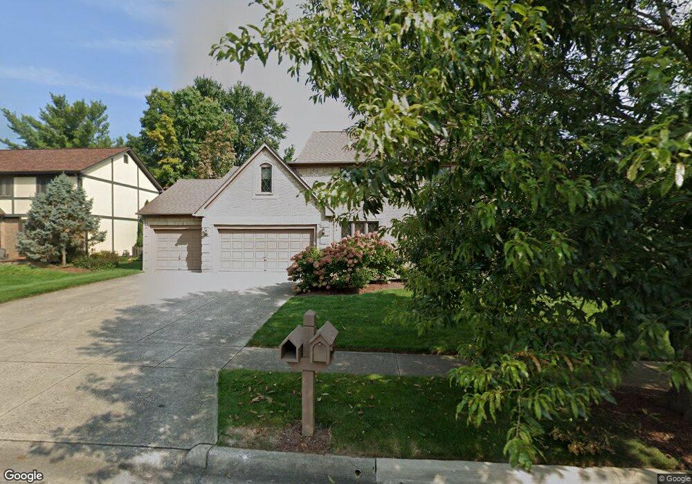
1064 Baumock Burn Dr Columbus, OH 43235
Stilson NeighborhoodEstimated Value: $563,000 - $756,000
4
Beds
3
Baths
3,254
Sq Ft
$196/Sq Ft
Est. Value
About This Home
This home is located at 1064 Baumock Burn Dr, Columbus, OH 43235 and is currently estimated at $637,574, approximately $195 per square foot. 1064 Baumock Burn Dr is a home located in Franklin County with nearby schools including Bluffsview Elementary School, McCord Middle School, and Worthington Kilbourne High School.
Ownership History
Date
Name
Owned For
Owner Type
Purchase Details
Closed on
Feb 19, 1993
Bought by
Davison Thomas C B
Current Estimated Value
Purchase Details
Closed on
Aug 1, 1985
Purchase Details
Closed on
Mar 1, 1984
Create a Home Valuation Report for This Property
The Home Valuation Report is an in-depth analysis detailing your home's value as well as a comparison with similar homes in the area
Home Values in the Area
Average Home Value in this Area
Purchase History
| Date | Buyer | Sale Price | Title Company |
|---|---|---|---|
| Davison Thomas C B | -- | -- | |
| -- | $205,700 | -- | |
| -- | $41,500 | -- |
Source: Public Records
Tax History
| Year | Tax Paid | Tax Assessment Tax Assessment Total Assessment is a certain percentage of the fair market value that is determined by local assessors to be the total taxable value of land and additions on the property. | Land | Improvement |
|---|---|---|---|---|
| 2025 | $12,171 | $208,040 | $41,930 | $166,110 |
| 2024 | $12,171 | $208,040 | $41,930 | $166,110 |
| 2023 | $11,675 | $208,040 | $41,930 | $166,110 |
| 2022 | $10,743 | $153,940 | $25,240 | $128,700 |
| 2021 | $9,911 | $153,940 | $25,240 | $128,700 |
| 2020 | $9,546 | $153,940 | $25,240 | $128,700 |
| 2019 | $9,010 | $132,410 | $21,950 | $110,460 |
| 2018 | $8,716 | $132,410 | $21,950 | $110,460 |
| 2017 | $8,074 | $132,410 | $21,950 | $110,460 |
| 2016 | $8,702 | $131,320 | $24,010 | $107,310 |
| 2015 | $8,704 | $131,320 | $24,010 | $107,310 |
| 2014 | $8,701 | $131,320 | $24,010 | $107,310 |
| 2013 | $4,072 | $124,040 | $21,840 | $102,200 |
Source: Public Records
Map
Nearby Homes
- 1380 Tiehack Ct
- 7164 Durness Place
- 7556 Antrim Ridge St
- 6784 Heathview St
- 6885 Ravine Cir
- 812 Hard Rd
- 7370 Coldstream Dr
- 2687 Snouffer Rd
- 784 Pinecliff Place
- 6550 Winston Ct E
- 110 Whieldon Ln
- 6637 Merwin Rd
- 6747 Merwin Rd
- 1930 Shallowford Ave
- 941 Clubview Blvd S
- 7034 Rockhaven Place
- 6876 Spruce Pine Dr
- 203 Saint Pierre St
- 1967 Slaton Ct
- 120 Saint Julien St Unit 36C
- 1076 Baumock Burn Dr
- 1052 Baumock Burn Dr
- 6997 Branch St
- 1088 Baumock Burn Dr
- 1079 Cross Country Dr
- 1040 Baumock Burn Dr
- 1071 Cross Country Dr
- 1071 Baumock Burn Dr
- 6937 Bonnie Brae Ln
- 1079 Baumock Burn Dr
- 1091 Cross Country Dr
- 1100 Baumock Burn Dr
- 6949 Bonnie Brae Ln
- 1093 Baumock Burn Dr
- 7010 Branch St
- 1072 Limberlost Ct
- 6929 Bonnie Brae Ln
- 1101 Cross Country Dr
- 7002 Branch St
- 1045 Cross Country Dr