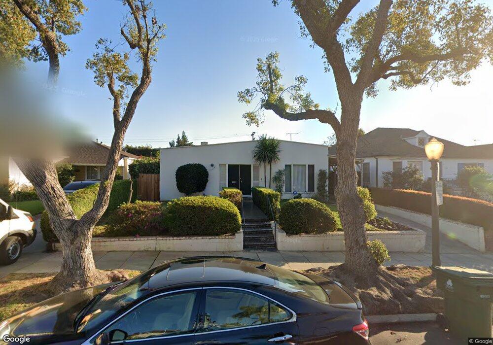
10664 Rochester Ave Los Angeles, CA 90024
Westwood NeighborhoodEstimated Value: $1,801,000 - $2,391,000
2
Beds
2
Baths
1,466
Sq Ft
$1,494/Sq Ft
Est. Value
About This Home
This home is located at 10664 Rochester Ave, Los Angeles, CA 90024 and is currently estimated at $2,189,627, approximately $1,493 per square foot. 10664 Rochester Ave is a home located in Los Angeles County with nearby schools including Fairburn Avenue Elementary, Westwood Charter School, and Ralph Waldo Emerson Community Charter Middle School.
Ownership History
Date
Name
Owned For
Owner Type
Purchase Details
Closed on
Oct 30, 1997
Sold by
Paidavosy Parviz
Bought by
Paidavosy Parviz and Paidavosy Manijeh S
Current Estimated Value
Purchase Details
Closed on
Jun 15, 1994
Sold by
Forti Milka
Bought by
Paidavosy Parviz and Paidavosy Manijeh S
Purchase Details
Closed on
Jun 14, 1994
Sold by
Janss Investment Corp
Bought by
Paidavosy Parviz and Paidavosy Manijeh
Create a Home Valuation Report for This Property
The Home Valuation Report is an in-depth analysis detailing your home's value as well as a comparison with similar homes in the area
Home Values in the Area
Average Home Value in this Area
Purchase History
| Date | Buyer | Sale Price | Title Company |
|---|---|---|---|
| Paidavosy Parviz | -- | -- | |
| Paidavosy Parviz | $372,500 | Equity Title | |
| Paidavosy Parviz | -- | Equity Title |
Source: Public Records
Tax History Compared to Growth
Tax History
| Year | Tax Paid | Tax Assessment Tax Assessment Total Assessment is a certain percentage of the fair market value that is determined by local assessors to be the total taxable value of land and additions on the property. | Land | Improvement |
|---|---|---|---|---|
| 2025 | $7,790 | $633,107 | $474,714 | $158,393 |
| 2024 | $7,790 | $620,694 | $465,406 | $155,288 |
| 2023 | $7,645 | $608,525 | $456,281 | $152,244 |
| 2022 | $7,299 | $596,594 | $447,335 | $149,259 |
| 2021 | $7,206 | $584,897 | $438,564 | $146,333 |
| 2019 | $6,994 | $567,551 | $425,557 | $141,994 |
| 2018 | $6,903 | $556,423 | $417,213 | $139,210 |
| 2016 | $6,600 | $534,818 | $401,013 | $133,805 |
| 2015 | $6,505 | $526,786 | $394,990 | $131,796 |
| 2014 | $6,534 | $516,468 | $387,253 | $129,215 |
Source: Public Records
Map
Nearby Homes
- 10671 Wilkins Ave Unit 5
- 10687 Wilkins Ave Unit 1
- 10721 Ohio Ave
- 10725 Ohio Ave Unit PH2
- 10725 Ohio Ave Unit 301
- 1551 Manning Ave Unit 101
- 10633 Kinnard Ave Unit 1
- 10735 Rochester Ave
- 10745 Ohio Ave
- 10600 Wilkins Ave Unit 3D
- 1601 Hilts Ave Unit 3
- 1567 Westholme Ave Unit 4A
- 10627 Ashton Ave Unit 103
- 10611 Ashton Ave Unit 1
- 10660 Wilshire Blvd Unit 609
- 1621 Manning Ave
- 10724 Wilshire Blvd Unit 1001
- 10724 Wilshire Blvd Unit 1209
- 10724 Wilshire Blvd Unit 1501
- 10724 Wilshire Blvd Unit 1402
- 10660 Rochester Ave
- 10670 Rochester Ave
- 10654 Rochester Ave
- 10674 Rochester Ave
- 10661 Ohio Ave
- 10667 Ohio Ave
- 10657 Ohio Ave
- 10650 Rochester Ave
- 10678 Rochester Ave
- 10671 Ohio Ave
- 10651 Ohio Ave
- 10663 Rochester Ave
- 10677 Ohio Ave
- 10669 Rochester Ave
- 10646 Rochester Ave
- 10659 Rochester Ave
- 10647 Ohio Ave
- 10675 Rochester Ave
- 1320 Manning Ave
- 10641 Ohio Ave