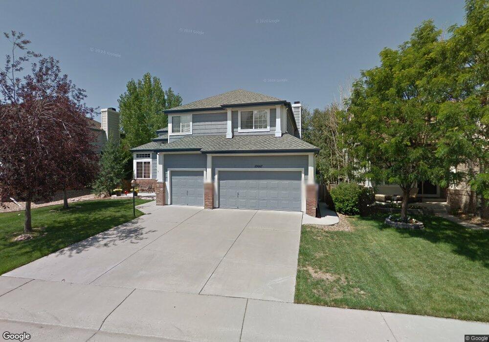
10667 Stone Creek Ct Parker, CO 80134
Stonegate NeighborhoodEstimated Value: $710,565 - $779,000
4
Beds
3
Baths
3,558
Sq Ft
$207/Sq Ft
Est. Value
About This Home
This home is located at 10667 Stone Creek Ct, Parker, CO 80134 and is currently estimated at $738,141, approximately $207 per square foot. 10667 Stone Creek Ct is a home located in Douglas County with nearby schools including Pine Grove Elementary School, Sierra Middle School, and Chaparral High School.
Ownership History
Date
Name
Owned For
Owner Type
Purchase Details
Closed on
May 15, 2012
Sold by
Mcatee Alan A and Woodhurst Mcatee Deborah A
Bought by
Vangorder Robert and Vangorder Julie A
Current Estimated Value
Home Financials for this Owner
Home Financials are based on the most recent Mortgage that was taken out on this home.
Original Mortgage
$346,055
Outstanding Balance
$241,109
Interest Rate
4.02%
Mortgage Type
VA
Estimated Equity
$497,032
Purchase Details
Closed on
Mar 31, 2004
Sold by
Buller Andrew J and Buller Amelia S
Bought by
Mcatee Alan A and Woodhurst Mcatee Deborah A
Home Financials for this Owner
Home Financials are based on the most recent Mortgage that was taken out on this home.
Original Mortgage
$263,200
Interest Rate
3.35%
Mortgage Type
Unknown
Purchase Details
Closed on
Jul 17, 2001
Sold by
Colbrese Victor A and Colbrese Nancy R
Bought by
Buller Andrew J and Buller Amelia S
Home Financials for this Owner
Home Financials are based on the most recent Mortgage that was taken out on this home.
Original Mortgage
$260,000
Interest Rate
6.12%
Purchase Details
Closed on
Jul 2, 2001
Sold by
Colbrese Victor A and Colbrese Nancy R
Bought by
Buller Andrew J and Buller Amelia S
Home Financials for this Owner
Home Financials are based on the most recent Mortgage that was taken out on this home.
Original Mortgage
$260,000
Interest Rate
6.12%
Purchase Details
Closed on
Jan 29, 1999
Sold by
Borrelli Thomas A
Bought by
Colbrese Victor A and Colbrese Nancy R
Home Financials for this Owner
Home Financials are based on the most recent Mortgage that was taken out on this home.
Original Mortgage
$157,000
Interest Rate
6.79%
Purchase Details
Closed on
Apr 29, 1997
Sold by
Falcon Partnership Ltd
Bought by
Borrelli Thomas A
Home Financials for this Owner
Home Financials are based on the most recent Mortgage that was taken out on this home.
Original Mortgage
$153,000
Interest Rate
7.5%
Purchase Details
Closed on
Feb 9, 1996
Sold by
Stonegate Dev Inc
Bought by
Falcon Partnership
Create a Home Valuation Report for This Property
The Home Valuation Report is an in-depth analysis detailing your home's value as well as a comparison with similar homes in the area
Home Values in the Area
Average Home Value in this Area
Purchase History
| Date | Buyer | Sale Price | Title Company |
|---|---|---|---|
| Vangorder Robert | $335,000 | Fidelity National Title Insu | |
| Mcatee Alan A | $329,000 | Land Title | |
| Buller Andrew J | $325,000 | -- | |
| Buller Andrew J | $325,000 | -- | |
| Colbrese Victor A | $247,000 | -- | |
| Borrelli Thomas A | $222,872 | -- | |
| Falcon Partnership | $347,100 | -- |
Source: Public Records
Mortgage History
| Date | Status | Borrower | Loan Amount |
|---|---|---|---|
| Open | Vangorder Robert | $346,055 | |
| Previous Owner | Mcatee Alan A | $263,200 | |
| Previous Owner | Buller Andrew J | $260,000 | |
| Previous Owner | Colbrese Victor A | $157,000 | |
| Previous Owner | Borrelli Thomas A | $153,000 | |
| Closed | Mcatee Alan A | $49,350 |
Source: Public Records
Tax History Compared to Growth
Tax History
| Year | Tax Paid | Tax Assessment Tax Assessment Total Assessment is a certain percentage of the fair market value that is determined by local assessors to be the total taxable value of land and additions on the property. | Land | Improvement |
|---|---|---|---|---|
| 2024 | $4,977 | $50,170 | $8,850 | $41,320 |
| 2023 | $5,020 | $50,170 | $8,850 | $41,320 |
| 2022 | $3,818 | $34,590 | $6,040 | $28,550 |
| 2021 | $3,926 | $34,590 | $6,040 | $28,550 |
| 2020 | $3,902 | $35,240 | $6,660 | $28,580 |
| 2019 | $3,807 | $35,240 | $6,660 | $28,580 |
| 2018 | $3,498 | $31,940 | $5,990 | $25,950 |
| 2017 | $3,299 | $31,940 | $5,990 | $25,950 |
| 2016 | $3,262 | $31,090 | $5,570 | $25,520 |
| 2015 | $3,325 | $31,090 | $5,570 | $25,520 |
| 2014 | $3,199 | $26,960 | $5,410 | $21,550 |
Source: Public Records
Map
Nearby Homes
- 10553 Stonemeadow Dr
- 10828 Snowdon St
- 10676 Cottoneaster Way
- 10834 Snowdon St
- 10832 Tundra Top Dr
- 10849 Tundra Top Dr
- 16116 Martingale Dr
- 10873 Tundra Top Dr
- 10896 Snowdon St
- 15565 Flowerhill Cir
- 10818 Mcclellan Rd
- 15733 Mccauley Dr
- 10730 Tomboy Dr
- Pinnacle Plan at Newlin Crossing - The Pioneer Collection
- Graham Plan at Newlin Crossing - The Monarch Collection
- Ashbrook Plan at Newlin Crossing - The Monarch Collection
- Evans Plan at Newlin Crossing - The Pioneer Collection
- Stonehaven Plan at Newlin Crossing - The Monarch Collection
- 10734 Tomboy Dr
- Chelton Plan at Newlin Crossing - The Monarch Collection
- 10657 Stone Creek Ct
- 10677 Stone Creek Ct
- 15911 Crestrock Cir
- 15921 Crestrock Cir
- 10647 Stone Creek Ct
- 15901 Crestrock Cir
- 10668 Stone Creek Ct
- 10658 Stone Creek Ct
- 15891 Crestrock Cir
- 10678 Stone Creek Ct
- 10637 Stone Creek Ct
- 10648 Stone Creek Ct
- 15962 Crestrock Cir
- 15972 Crestrock Cir
- 15952 Crestrock Cir
- 15881 Crestrock Cir
- 15982 Crestrock Cir
- 15942 Crestrock Cir
- 10627 Stone Creek Ct
- 10638 Stone Creek Ct