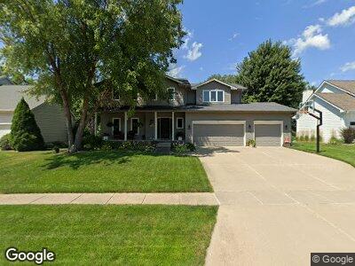
1068 66th Place West Des Moines, IA 50266
Estimated Value: $421,000 - $449,000
4
Beds
3
Baths
2,323
Sq Ft
$185/Sq Ft
Est. Value
About This Home
This home is located at 1068 66th Place, West Des Moines, IA 50266 and is currently estimated at $429,130, approximately $184 per square foot. 1068 66th Place is a home located in Dallas County with nearby schools including Brookview Elementary School, South Middle School, and Prairieview Middle School.
Ownership History
Date
Name
Owned For
Owner Type
Purchase Details
Closed on
Aug 11, 2011
Sold by
Woods Rodney C and Woods Kathryn L
Bought by
Alsin David L and Alsin Michelle D
Current Estimated Value
Home Financials for this Owner
Home Financials are based on the most recent Mortgage that was taken out on this home.
Original Mortgage
$202,000
Outstanding Balance
$143,177
Interest Rate
4.55%
Mortgage Type
New Conventional
Estimated Equity
$288,509
Purchase Details
Closed on
Dec 23, 2010
Sold by
Burgus Dani Lec and Burgus Judy Ann
Bought by
Burgus Farm Llc
Create a Home Valuation Report for This Property
The Home Valuation Report is an in-depth analysis detailing your home's value as well as a comparison with similar homes in the area
Home Values in the Area
Average Home Value in this Area
Purchase History
| Date | Buyer | Sale Price | Title Company |
|---|---|---|---|
| Alsin David L | $252,500 | None Available | |
| Burgus Farm Llc | -- | None Available |
Source: Public Records
Mortgage History
| Date | Status | Borrower | Loan Amount |
|---|---|---|---|
| Open | Alsin David L | $202,000 | |
| Previous Owner | Woods Rodney C | $25,000 |
Source: Public Records
Tax History Compared to Growth
Tax History
| Year | Tax Paid | Tax Assessment Tax Assessment Total Assessment is a certain percentage of the fair market value that is determined by local assessors to be the total taxable value of land and additions on the property. | Land | Improvement |
|---|---|---|---|---|
| 2023 | $6,066 | $372,260 | $75,000 | $297,260 |
| 2022 | $5,686 | $323,910 | $75,000 | $248,910 |
| 2021 | $5,686 | $307,300 | $65,000 | $242,300 |
| 2020 | $5,472 | $286,390 | $65,000 | $221,390 |
| 2019 | $5,344 | $286,390 | $65,000 | $221,390 |
| 2018 | $5,344 | $266,650 | $60,000 | $206,650 |
| 2017 | $5,022 | $266,650 | $60,000 | $206,650 |
| 2016 | $4,904 | $244,300 | $45,000 | $199,300 |
| 2015 | $4,756 | $244,300 | $0 | $0 |
| 2014 | $4,756 | $244,300 | $0 | $0 |
Source: Public Records
Map
Nearby Homes
- 6855 Woodland Ave Unit 608
- 6562 Center St
- 1045 68th St Unit 2
- 6531 Bradford Dr
- 1205 65th Place
- 1030 68th St Unit 8
- 1050 68th St Unit 8
- 980 65th St
- 950 67th St Unit 321
- 989 65th St
- 6800 Ashworth Rd Unit 602
- 6178 Aspen Dr
- 712 63rd St
- 5909 Brookview Dr
- 681 63rd St
- 5829 Center St
- 1028 58th St
- 645 65th Place Unit 186
- 645 65th Place Unit 131
- 645 65th Place Unit 188
- 1068 66th Place
- 1076 66th Place
- 1060 66th Place
- 1052 66th Place
- 1104 66th Place
- 6563 Orchard Dr
- 1120 66th Place
- 1044 66th Place
- 828 65th St
- 6554 Woodland Dr
- 6565 Woodland Dr
- 6551 Orchard Dr
- 1036 66th Place
- 1136 66th Place
- 1055 68th St Unit 6
- 1055 68th St Unit 8
- 1055 68th St Unit 5
- 1055 68th St Unit 4
- 1055 68th St
- 1055 68th St Unit 3