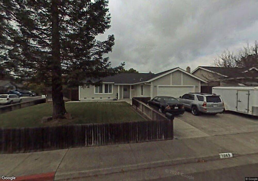
1069 Wren Dr Petaluma, CA 94954
Adobe NeighborhoodEstimated Value: $751,325 - $855,000
3
Beds
2
Baths
1,497
Sq Ft
$536/Sq Ft
Est. Value
About This Home
This home is located at 1069 Wren Dr, Petaluma, CA 94954 and is currently estimated at $802,831, approximately $536 per square foot. 1069 Wren Dr is a home located in Sonoma County with nearby schools including La Tercera Elementary School, Kenilworth Junior High School, and Casa Grande High School.
Ownership History
Date
Name
Owned For
Owner Type
Purchase Details
Closed on
Apr 16, 2018
Sold by
Freitas Darrel M and Freitas Nancy C
Bought by
Freitas Mark
Current Estimated Value
Purchase Details
Closed on
Aug 3, 2004
Sold by
Freitas Darrel and Freitas Nancy
Bought by
Freitas Darrel M and Freitas Nancy C
Purchase Details
Closed on
Nov 15, 2002
Sold by
Freitas Mark and Freitas Darrel
Bought by
Freitas Mark and Freitas Darrel
Purchase Details
Closed on
Mar 22, 2002
Sold by
Sawicky Michael E and Maguire Maureen L
Bought by
Freitas Darrel and Freitas Nancy
Home Financials for this Owner
Home Financials are based on the most recent Mortgage that was taken out on this home.
Original Mortgage
$213,750
Outstanding Balance
$87,906
Interest Rate
6.84%
Mortgage Type
Stand Alone First
Estimated Equity
$714,925
Create a Home Valuation Report for This Property
The Home Valuation Report is an in-depth analysis detailing your home's value as well as a comparison with similar homes in the area
Home Values in the Area
Average Home Value in this Area
Purchase History
| Date | Buyer | Sale Price | Title Company |
|---|---|---|---|
| Freitas Mark | -- | None Available | |
| Freitas Darrel M | -- | -- | |
| Freitas Mark | -- | Old Republic Title Co | |
| Freitas Darrel | $342,000 | Old Republic Title Company |
Source: Public Records
Mortgage History
| Date | Status | Borrower | Loan Amount |
|---|---|---|---|
| Open | Freitas Darrel | $213,750 |
Source: Public Records
Tax History
| Year | Tax Paid | Tax Assessment Tax Assessment Total Assessment is a certain percentage of the fair market value that is determined by local assessors to be the total taxable value of land and additions on the property. | Land | Improvement |
|---|---|---|---|---|
| 2025 | $5,547 | $505,226 | $280,683 | $224,543 |
| 2024 | $5,547 | $495,321 | $275,180 | $220,141 |
| 2023 | $5,547 | $485,610 | $269,785 | $215,825 |
| 2022 | $5,420 | $476,090 | $264,496 | $211,594 |
| 2021 | $5,358 | $466,756 | $259,310 | $207,446 |
| 2020 | $5,396 | $461,971 | $256,652 | $205,319 |
| 2019 | $5,341 | $452,914 | $251,620 | $201,294 |
| 2018 | $5,186 | $444,035 | $246,687 | $197,348 |
| 2017 | $5,111 | $435,329 | $241,850 | $193,479 |
| 2016 | $4,953 | $426,794 | $237,108 | $189,686 |
| 2015 | $4,825 | $420,384 | $233,547 | $186,837 |
| 2014 | $4,777 | $412,151 | $228,973 | $183,178 |
Source: Public Records
Map
Nearby Homes
- 16 Arrowhead Ct
- 1212 Del Rancho Way
- 2403 Marylyn Cir
- 1097 Crinella Dr
- 815 Whitney Way
- 800 Mckillop Ct
- 1168 Wieling Way
- 1636 Caulfield Ln
- 1109 Saint Vincent Ct
- 1280 Saint Francis Dr
- 3571 Old Adobe Rd
- 843 Cedarwood Ln
- 1313 Mcgregor Ave
- 1713 Alhambra Ct
- 3957 Lakeville Hwy
- 11 Montclair Ct
- 1642 Lauren Dr
- 1321 Mcneil Ave
- 4091 Lakeville Hwy
- 540 Sapphire St
Your Personal Tour Guide
Ask me questions while you tour the home.