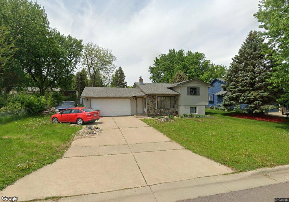
107 S Detroit Ave Sioux Falls, SD 57110
Northeast Sioux Falls NeighborhoodEstimated Value: $264,505 - $279,000
3
Beds
2
Baths
1,486
Sq Ft
$181/Sq Ft
Est. Value
About This Home
This home is located at 107 S Detroit Ave, Sioux Falls, SD 57110 and is currently estimated at $268,876, approximately $180 per square foot. 107 S Detroit Ave is a home located in Minnehaha County with nearby schools including Rosa Parks Elementary School, Washington High School, and Sioux Falls Christian Elementary School.
Ownership History
Date
Name
Owned For
Owner Type
Purchase Details
Closed on
Sep 3, 2021
Sold by
Hauser Bo Riley and Hauser Alex
Bought by
Catrett Nicole Ashley Rae and Catrett Brock Michael
Current Estimated Value
Purchase Details
Closed on
Jul 14, 2017
Sold by
Pesicka Travis and Pesicka Brenda
Bought by
Hauser Bo R and Hauser Alex
Purchase Details
Closed on
Jun 22, 2012
Sold by
Travis Travis and Pesicka Brenda
Bought by
Pesicka Travis and Pesicka Brenda
Create a Home Valuation Report for This Property
The Home Valuation Report is an in-depth analysis detailing your home's value as well as a comparison with similar homes in the area
Home Values in the Area
Average Home Value in this Area
Purchase History
| Date | Buyer | Sale Price | Title Company |
|---|---|---|---|
| Catrett Nicole Ashley Rae | $200,000 | Stewart Title Company | |
| Hauser Bo R | $162,000 | -- | |
| Pesicka Travis | $126,000 | Rels Title |
Source: Public Records
Tax History Compared to Growth
Tax History
| Year | Tax Paid | Tax Assessment Tax Assessment Total Assessment is a certain percentage of the fair market value that is determined by local assessors to be the total taxable value of land and additions on the property. | Land | Improvement |
|---|---|---|---|---|
| 2024 | $2,900 | $209,000 | $35,400 | $173,600 |
| 2023 | $2,834 | $196,600 | $35,400 | $161,200 |
| 2022 | $2,828 | $185,200 | $35,400 | $149,800 |
| 2021 | $2,389 | $156,800 | $0 | $0 |
| 2020 | $2,389 | $149,200 | $0 | $0 |
| 2019 | $2,417 | $148,552 | $0 | $0 |
| 2018 | $2,292 | $143,572 | $0 | $0 |
| 2017 | $2,081 | $141,580 | $32,020 | $109,560 |
| 2016 | $2,081 | $128,061 | $32,020 | $96,041 |
| 2015 | $2,119 | $128,259 | $32,013 | $96,246 |
| 2014 | $1,974 | $125,701 | $32,013 | $93,688 |
Source: Public Records
Map
Nearby Homes
- 120 N Detroit Ave
- 119 N La Salle Cir
- 108 S Sycamore Ave
- 4800 Grant St
- 305 N Marquette Ave
- 5201 E Quincey St
- 800 802 N Marquette Ave
- 707 709 N Marquette Ave
- 200 S Dewberry Cir
- 316 N Holiday Ave
- 4835 E Hanover Cir
- 101 S Foss Ave
- 600 S Charlotte Ave
- 604 S Charlotte Ave
- 813 N Marquette Ave
- 401 N Meyer Ln
- 509 S Kennedy Ave
- 4912 E Brennan Dr
- 4509 -4515 E 3rd st St
- 704 S Rohl Dr
- 103 S Detroit Ave
- 4710 E Taylor St
- 4708 E Taylor St
- 101 N Detroit Ave
- 4706 E Taylor St
- 100 S Hampton Ave
- 110 S Detroit Ave
- 4800 E Taylor St
- 100 S Detroit Ave
- 105 N Detroit Ave
- 100 N Hampton Ave
- 100 N Detroit Ave
- 4709 E Taylor St
- 109 N Detroit Ave
- 104 N Hampton Ave
- 104 N Detroit Ave
- 4703 E Taylor St
- 4705 E Taylor St
- 111 S Hampton Ave
- 108 N Hampton Ave