Estimated Value: $373,646 - $469,000
4
Beds
3
Baths
2,436
Sq Ft
$172/Sq Ft
Est. Value
About This Home
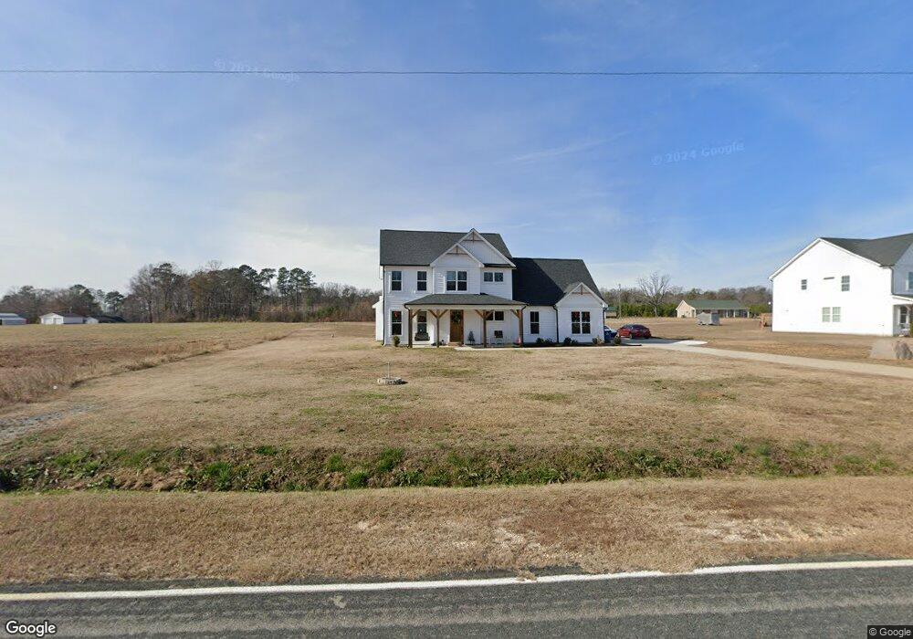
This home is located at 1070 W Strickland Rd Unit Lot 1, Dunn, NC 28334 and is currently estimated at $418,912, approximately $171 per square foot. 1070 W Strickland Rd Unit Lot 1 is a home located in Harnett County with nearby schools including Dunn Elementary School, Wayne Avenue Elementary School, and Dunn Middle School.
Ownership History
Date
Name
Owned For
Owner Type
Purchase Details
Closed on
Jul 8, 2020
Sold by
Grady Z Dewitt Z and Grady Pearl
Bought by
Douglas David K and Douglas Taylor J
Current Estimated Value
Home Financials for this Owner
Home Financials are based on the most recent Mortgage that was taken out on this home.
Original Mortgage
$261,000
Outstanding Balance
$231,524
Interest Rate
3.12%
Mortgage Type
Construction
Estimated Equity
$187,388
Purchase Details
Closed on
Jun 18, 2002
Bought by
Grady Land Services Inc Tic
Create a Home Valuation Report for This Property
The Home Valuation Report is an in-depth analysis detailing your home's value as well as a comparison with similar homes in the area
Home Values in the Area
Average Home Value in this Area
Purchase History
| Date | Buyer | Sale Price | Title Company |
|---|---|---|---|
| Douglas David K | $45,000 | None Available | |
| Grady Land Services Inc Tic | $265,000 | -- |
Source: Public Records
Mortgage History
| Date | Status | Borrower | Loan Amount |
|---|---|---|---|
| Open | Douglas David K | $261,000 |
Source: Public Records
Tax History Compared to Growth
Tax History
| Year | Tax Paid | Tax Assessment Tax Assessment Total Assessment is a certain percentage of the fair market value that is determined by local assessors to be the total taxable value of land and additions on the property. | Land | Improvement |
|---|---|---|---|---|
| 2025 | $2,126 | $291,111 | $0 | $0 |
| 2024 | $2,126 | $291,111 | $0 | $0 |
| 2023 | $2,126 | $291,111 | $0 | $0 |
| 2022 | $1,895 | $291,111 | $0 | $0 |
| 2021 | $1,895 | $210,430 | $0 | $0 |
| 2020 | $155 | $18,000 | $0 | $0 |
| 2019 | $155 | $18,000 | $0 | $0 |
| 2018 | $155 | $18,000 | $0 | $0 |
| 2017 | $155 | $18,000 | $0 | $0 |
| 2016 | $155 | $18,000 | $0 | $0 |
| 2015 | -- | $18,000 | $0 | $0 |
| 2014 | -- | $18,000 | $0 | $0 |
Source: Public Records
Map
Nearby Homes
- 0 W Strickland Rd Unit 10125114
- 1049 Jada Allen Rd
- 1 Jonesboro Rd
- 919 Drag Strip Rd
- 670 W Core Rd
- 0 W Core Rd Unit 10086773
- 596 Lane Rd
- 1161 Stewart Rd
- 107 Mars Dr
- 168 Tanning Ridge Dr
- 8670 Green Path Rd
- 117 Mars Dr
- 300 Saturn St
- 61 Athens Ln
- 130 Surles Landing Way
- 171 Surles Landing Way
- 1602 Lake Shore Dr
- 186 Surles Landing Way
- 178 Surles Landing Way
- 1070 W Strickland Rd
- 1050 W Strickland Rd
- 1030 W Strickland Rd
- 1004 W Strickland Rd
- 795 Wise Rd
- 763 Wise Rd
- 768 Wise Rd
- 810 Wise Rd
- 1010 Wise Rd
- 0 Wise Rd Unit TR2160357
- 0 Wise Rd Unit TR2191396
- 0 Wise Rd Unit TR2255456
- 0 Wise Rd Unit 1862072
- 0 Wise Rd
- 595 Wise Rd
- 117 Bill Place Ln
- 565 Wise Rd
- 533 Wise Rd
- 55 Carol St
- 735 W Strickland Rd