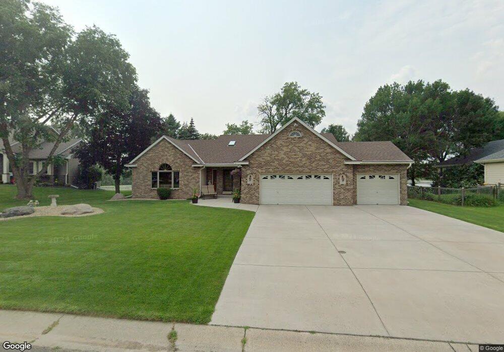
1071 Dunbar Way Saint Paul, MN 55115
Estimated Value: $575,000 - $670,000
3
Beds
4
Baths
2,733
Sq Ft
$230/Sq Ft
Est. Value
About This Home
This home is located at 1071 Dunbar Way, Saint Paul, MN 55115 and is currently estimated at $628,638, approximately $230 per square foot. 1071 Dunbar Way is a home located in Washington County with nearby schools including O.H. Anderson Elementary School, Wildwood Elementary School, and Mahtomedi Middle School.
Ownership History
Date
Name
Owned For
Owner Type
Purchase Details
Closed on
May 6, 2011
Sold by
Weber Harold J
Bought by
Meissner Thomas S and Meissner Shari J
Current Estimated Value
Home Financials for this Owner
Home Financials are based on the most recent Mortgage that was taken out on this home.
Original Mortgage
$228,000
Interest Rate
4.63%
Mortgage Type
New Conventional
Create a Home Valuation Report for This Property
The Home Valuation Report is an in-depth analysis detailing your home's value as well as a comparison with similar homes in the area
Home Values in the Area
Average Home Value in this Area
Purchase History
| Date | Buyer | Sale Price | Title Company |
|---|---|---|---|
| Meissner Thomas S | $368,204 | -- |
Source: Public Records
Mortgage History
| Date | Status | Borrower | Loan Amount |
|---|---|---|---|
| Previous Owner | Meissner Thomas S | $228,000 |
Source: Public Records
Tax History Compared to Growth
Tax History
| Year | Tax Paid | Tax Assessment Tax Assessment Total Assessment is a certain percentage of the fair market value that is determined by local assessors to be the total taxable value of land and additions on the property. | Land | Improvement |
|---|---|---|---|---|
| 2024 | $6,366 | $539,100 | $186,000 | $353,100 |
| 2023 | $6,366 | $531,900 | $196,000 | $335,900 |
| 2022 | $5,902 | $524,100 | $196,000 | $328,100 |
| 2021 | $6,166 | $419,500 | $160,000 | $259,500 |
| 2020 | $6,076 | $453,300 | $195,000 | $258,300 |
| 2019 | $5,714 | $439,200 | $173,000 | $266,200 |
| 2018 | $5,660 | $419,400 | $180,000 | $239,400 |
| 2017 | $6,128 | $445,200 | $216,500 | $228,700 |
| 2016 | $6,278 | $456,700 | $233,500 | $223,200 |
| 2015 | $6,186 | $447,400 | $195,500 | $251,900 |
| 2013 | -- | $417,600 | $170,700 | $246,900 |
Source: Public Records
Map
Nearby Homes
- 78 Dunbar Way
- 941 Pineridge Ct
- 13 Echo Lake Blvd
- 907 Ledgestone Dr
- 285 Old Wildwood Rd
- 739 Echo Shores Ct
- 745 Sterling Ct
- 824 Woodland Dr
- 766 Sterling Ct
- 169 Wedgewood Dr
- 180 Bevins Ln
- 2728 Century Ct
- 2671 Sumac Ridge
- 2667 Sumac Ridge
- 2608 Sumac Ridge
- XXXX Glen Oaks Ave
- 3532 Rolling View Dr
- 3533 Long Lake Rd E
- 3396 Glen Oaks Ave
- 3150 Glen Oaks Ave Unit 305
- 1091 Dunbar Way
- 1051 Dunbar Way
- 1051 Dunbar Way
- 1071 1071 Dunbar Way
- 1111 Dunbar Way
- 1031 Dunbar Way
- 363 Dunbar Knolls
- 363 Dunbar Knolls
- 363 Dunbar Knoll
- 338 Dunbar Way
- 361 Dunbar Way
- 1131 Dunbar Way
- 378 Dunbar Knolls
- 378 378 Dunbar
- 1131 1131 Dunbar Way
- 355 Dunbar Knolls
- 318 Dunbar Way
- 341 Dunbar Way
- 354 Dunbar Knolls
- 366 Dunbar Knolls