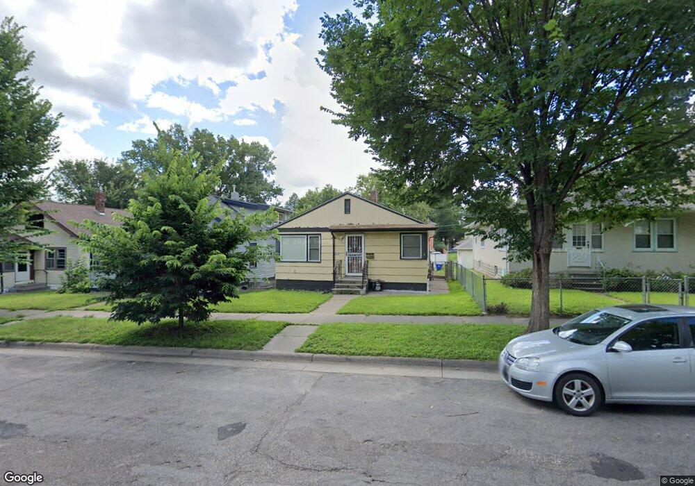
1072 Thomas Ave Saint Paul, MN 55104
Frogtown NeighborhoodEstimated Value: $234,000 - $272,000
4
Beds
2
Baths
988
Sq Ft
$252/Sq Ft
Est. Value
About This Home
This home is located at 1072 Thomas Ave, Saint Paul, MN 55104 and is currently estimated at $248,656, approximately $251 per square foot. 1072 Thomas Ave is a home located in Ramsey County with nearby schools including Maxfield Magnet Elementary School, Hidden River Middle School, and Central Senior High School.
Ownership History
Date
Name
Owned For
Owner Type
Purchase Details
Closed on
Dec 27, 2024
Sold by
Lt & Associates Llc
Bought by
Yang Marcus Zhen-Jay
Current Estimated Value
Purchase Details
Closed on
Mar 26, 2012
Sold by
Us Bank National Association
Bought by
Yang Lewis and Vy Muon
Purchase Details
Closed on
Aug 10, 2001
Sold by
Estate Of Janeen M Manis
Bought by
Miller Deryck
Create a Home Valuation Report for This Property
The Home Valuation Report is an in-depth analysis detailing your home's value as well as a comparison with similar homes in the area
Home Values in the Area
Average Home Value in this Area
Purchase History
| Date | Buyer | Sale Price | Title Company |
|---|---|---|---|
| Yang Marcus Zhen-Jay | $500 | None Listed On Document | |
| Yang Marcus Zhen-Jay | $500 | None Listed On Document | |
| Yang Lewis | $67,700 | -- | |
| Miller Deryck | $137,500 | -- |
Source: Public Records
Tax History
| Year | Tax Paid | Tax Assessment Tax Assessment Total Assessment is a certain percentage of the fair market value that is determined by local assessors to be the total taxable value of land and additions on the property. | Land | Improvement |
|---|---|---|---|---|
| 2025 | $4,132 | $238,900 | $25,000 | $213,900 |
| 2023 | $4,132 | $263,300 | $20,000 | $243,300 |
| 2022 | $3,532 | $269,100 | $20,000 | $249,100 |
| 2021 | $2,914 | $215,600 | $20,000 | $195,600 |
| 2020 | $2,756 | $183,600 | $10,000 | $173,600 |
| 2019 | $2,456 | $161,100 | $10,000 | $151,100 |
| 2018 | $1,914 | $141,200 | $10,000 | $131,200 |
| 2017 | $1,540 | $112,100 | $10,000 | $102,100 |
| 2016 | $1,756 | $0 | $0 | $0 |
| 2015 | $1,610 | $103,400 | $10,000 | $93,400 |
| 2014 | $1,602 | $0 | $0 | $0 |
Source: Public Records
Map
Nearby Homes
- 1078 Thomas Ave
- 1009 Sherburne Ave
- 971 Thomas Ave
- 1123 Sherburne Ave
- 1138 Sherburne Ave
- 936 Thomas Ave
- 968 Sherburne Ave
- 971 Aurora Ave
- 1214 Sherburne Ave
- 1179 Minnehaha Ave W
- 1010 Seminary Ave
- 1000 Seminary Ave
- 1191 Minnehaha Ave W
- 873 Sherburne Ave
- 1125 Central Ave W
- 863 Sherburne Ave
- 1153 Central Ave W
- 1155 Seminary Ave
- 856 Sherburne Ave
- 846 Sherburne Ave
- 1066 Thomas Ave
- 1064 Thomas Ave
- 1080 Thomas Ave
- 1060 Thomas Ave
- 1073 Edmund Ave
- 1056 Thomas Ave
- 1069 Edmund Ave
- 1065 Edmund Ave
- 592 Lexington Pkwy N
- 1090 Thomas Ave
- 1077 Edmund Ave W
- 588 Lexington Pkwy N
- 1054 Thomas Ave
- 1069 Thomas Ave
- 1073 Thomas Ave
- 1057 Edmund Ave
- 1065 Thomas Ave
- 1081 Thomas Ave
- 1057 Edmund Ave W
- 1085 Thomas Ave
Your Personal Tour Guide
Ask me questions while you tour the home.