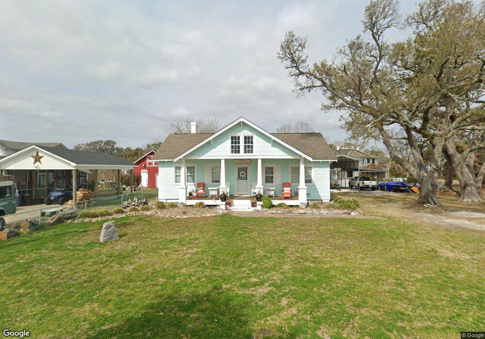
1081 Seashore Dr Atlantic, NC 28511
Estimated Value: $176,000 - $225,742
2
Beds
1
Bath
1,560
Sq Ft
$126/Sq Ft
Est. Value
About This Home
This home is located at 1081 Seashore Dr, Atlantic, NC 28511 and is currently estimated at $196,186, approximately $125 per square foot. 1081 Seashore Dr is a home located in Carteret County with nearby schools including Atlantic Elementary School and East Carteret High School.
Ownership History
Date
Name
Owned For
Owner Type
Purchase Details
Closed on
Jun 12, 2007
Sold by
Haning Phillip E and Haning Linda
Bought by
Turney Gregory D and Turney Kathy A
Current Estimated Value
Home Financials for this Owner
Home Financials are based on the most recent Mortgage that was taken out on this home.
Original Mortgage
$128,700
Outstanding Balance
$78,366
Interest Rate
6.1%
Mortgage Type
Purchase Money Mortgage
Estimated Equity
$117,820
Purchase Details
Closed on
May 24, 2007
Sold by
Haning Phillip E
Bought by
Haning Phillip E and Hardy Andrea H
Home Financials for this Owner
Home Financials are based on the most recent Mortgage that was taken out on this home.
Original Mortgage
$128,700
Outstanding Balance
$78,366
Interest Rate
6.1%
Mortgage Type
Purchase Money Mortgage
Estimated Equity
$117,820
Purchase Details
Closed on
Sep 27, 2006
Sold by
Haning Hazel W
Bought by
Haning Hazel W and The Hazel W Haning Revocable Trust
Purchase Details
Closed on
Sep 20, 2006
Sold by
Haning Hazel W
Bought by
Haning Phillip E and The Hazel W Haning Irrevocable Trust
Create a Home Valuation Report for This Property
The Home Valuation Report is an in-depth analysis detailing your home's value as well as a comparison with similar homes in the area
Home Values in the Area
Average Home Value in this Area
Purchase History
| Date | Buyer | Sale Price | Title Company |
|---|---|---|---|
| Turney Gregory D | $190,000 | None Available | |
| Haning Phillip E | -- | None Available | |
| Haning Hazel W | -- | None Available | |
| Haning Phillip E | -- | None Available |
Source: Public Records
Mortgage History
| Date | Status | Borrower | Loan Amount |
|---|---|---|---|
| Open | Turney Gregory D | $128,700 |
Source: Public Records
Tax History Compared to Growth
Tax History
| Year | Tax Paid | Tax Assessment Tax Assessment Total Assessment is a certain percentage of the fair market value that is determined by local assessors to be the total taxable value of land and additions on the property. | Land | Improvement |
|---|---|---|---|---|
| 2025 | $907 | $221,550 | $64,935 | $156,615 |
| 2024 | $792 | $133,377 | $52,470 | $80,907 |
| 2023 | $603 | $82,800 | $52,470 | $30,330 |
| 2022 | $594 | $82,800 | $52,470 | $30,330 |
| 2021 | $594 | $82,800 | $52,470 | $30,330 |
| 2020 | $602 | $82,800 | $52,470 | $30,330 |
| 2019 | $622 | $90,198 | $52,470 | $37,728 |
| 2017 | $622 | $90,198 | $52,470 | $37,728 |
| 2016 | $622 | $90,198 | $52,470 | $37,728 |
| 2015 | $613 | $90,198 | $52,470 | $37,728 |
| 2014 | $788 | $129,453 | $92,465 | $36,988 |
Source: Public Records
Map
Nearby Homes
- 376 Shell Rd
- 200 Lee Daniels Rd
- 120 Clem Fulcher Ct
- 620 Seashore Dr
- 540 Seashore Dr
- 216 Styron Creek Rd
- 198 Styron Creek Rd
- 188 Styron Creek Rd
- 196 Styron Creek
- 157 Styron Creek Rd
- 1268 Old Cedar Island Rd
- 200 Cedar Creek Rd
- 730 Highway 70 Sea Level
- 263 Nelson Neck Rd
- 149 Bayshore St
- 220 Nelson Neck Rd
- 250 Nelson Neck Rd
- 579 Nelson Neck Rd
- 616 Nelson Neck Rd
- 648 Shell Hill Rd
- 1091 Seashore Dr
- 1073 Seashore Dr
- 110 Morris Dr
- 124 Morris Dr
- 134 Morris Dr
- 1074 Seashore Dr
- 1097 Seashore Dr
- 1065 Seashore Dr
- 135 Morris Dr
- 1086 Seashore Dr
- 141 Morris Dr
- 121 Morris Dr
- 1098 Seashore Dr
- 172 Fulcher Dr
- 127 Willis Ln
- 181 Fulcher Dr
- 160 Fulcher Dr
- 154 Morris Dr
- 154 Fulcher Dr
- 1053 Seashore Dr