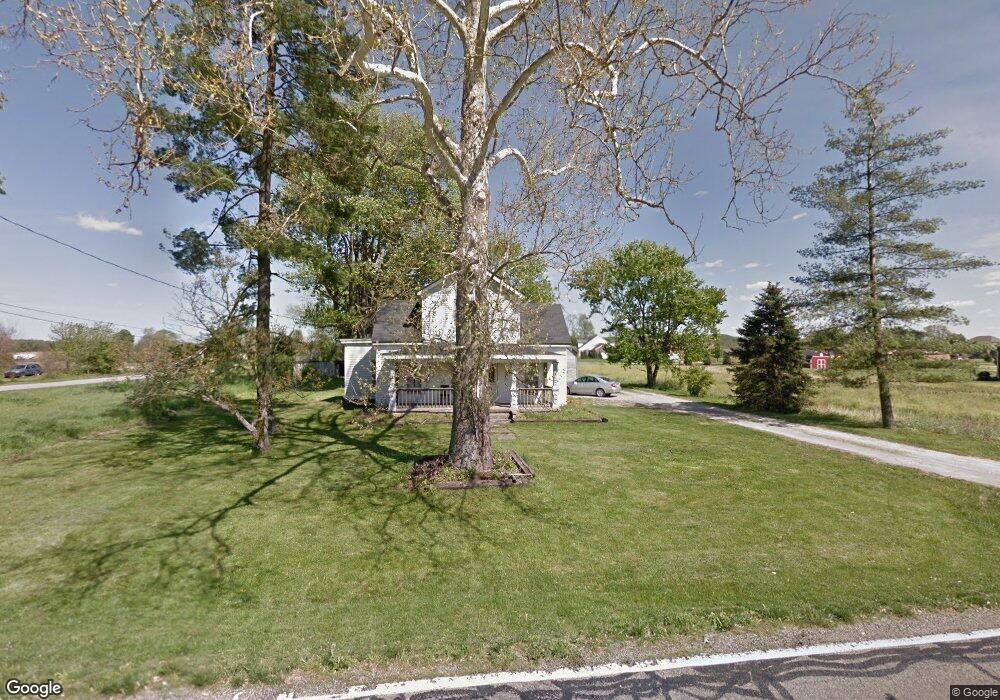
10880 Edgewood Rd Harrison, OH 45030
Estimated Value: $429,000 - $626,000
2
Beds
3
Baths
2,573
Sq Ft
$204/Sq Ft
Est. Value
About This Home
This home is located at 10880 Edgewood Rd, Harrison, OH 45030 and is currently estimated at $524,885, approximately $203 per square foot. 10880 Edgewood Rd is a home located in Hamilton County with nearby schools including William Henry Harrison High School, St. John The Baptist School, and Summit Academy of Southwest Ohio.
Ownership History
Date
Name
Owned For
Owner Type
Purchase Details
Closed on
Jul 20, 2015
Sold by
Crone Diana M and Niese Patricia Ann
Bought by
Crone Diane M and The Diana M Crone Trust
Current Estimated Value
Purchase Details
Closed on
Feb 26, 2009
Sold by
Crone M Mercy
Bought by
Crone M Mercy and The Mary Mercy Crone Trust
Purchase Details
Closed on
Jan 6, 2009
Sold by
Crone Pual J
Bought by
Crone M Mercy and The Mary Mercy Crone Trust
Purchase Details
Closed on
Jan 31, 2006
Sold by
Losekamp Enterprises Llc
Bought by
Crone M Mercy and Mary Mercy Crone Trust
Home Financials for this Owner
Home Financials are based on the most recent Mortgage that was taken out on this home.
Original Mortgage
$354,800
Interest Rate
6.48%
Mortgage Type
Unknown
Create a Home Valuation Report for This Property
The Home Valuation Report is an in-depth analysis detailing your home's value as well as a comparison with similar homes in the area
Purchase History
| Date | Buyer | Sale Price | Title Company |
|---|---|---|---|
| Crone Diane M | -- | Attorney | |
| Crone M Mercy | -- | None Available | |
| Crone M Mercy | -- | Attorney | |
| Crone M Mercy | $96,000 | None Available |
Source: Public Records
Mortgage History
| Date | Status | Borrower | Loan Amount |
|---|---|---|---|
| Previous Owner | Crone M Mercy | $354,800 |
Source: Public Records
Tax History
| Year | Tax Paid | Tax Assessment Tax Assessment Total Assessment is a certain percentage of the fair market value that is determined by local assessors to be the total taxable value of land and additions on the property. | Land | Improvement |
|---|---|---|---|---|
| 2025 | $7,335 | $178,686 | $40,383 | $138,303 |
| 2024 | $7,095 | $178,686 | $40,383 | $138,303 |
| 2023 | $7,166 | $178,686 | $40,383 | $138,303 |
| 2022 | $6,846 | $150,175 | $36,638 | $113,537 |
| 2021 | $6,782 | $150,175 | $36,638 | $113,537 |
| 2020 | $6,845 | $150,175 | $36,638 | $113,537 |
| 2019 | $6,591 | $126,200 | $30,790 | $95,410 |
| 2018 | $6,636 | $126,200 | $30,790 | $95,410 |
| 2017 | $6,319 | $126,200 | $30,790 | $95,410 |
| 2016 | $5,875 | $125,612 | $30,797 | $94,815 |
| 2015 | $5,236 | $125,612 | $30,797 | $94,815 |
| 2014 | $5,265 | $125,612 | $30,797 | $94,815 |
| 2013 | $5,362 | $125,612 | $30,797 | $94,815 |
Source: Public Records
Map
Nearby Homes
- 2430 Bartram Ln
- 2434 Bartram Ln
- acres Edgewood Rd
- 2438 Bartram Ln
- 9505 Morris Dr
- 1290 Trailhead Place
- 1270 Trailhead Place
- 2460 Bartram Ln
- 2474 Bartram Ln
- 1304 Trailhead Place
- 1316 Trailhead Place
- 1319 Trailhead Place
- 2465 Bartram Ln
- 2469 Bartram Ln
- 2475 Bartram Ln
- 1343 Springfield Dr
- 6056 Foothills Dr
- 2461 Bartram Ln
- 8039 Rock Island Dr
- 2463 Bartram Ln
- 10880 Edgewood Rd
- 10874 Edgewood Rd
- 10886 Edgewood Rd
- 10884 Edgewood Rd
- 10864 Edgewood Rd
- 10856 Edgewood Rd
- 10808 Edgewood Rd Unit 6
- 10808 Edgewood Rd Unit 7
- 10808 Edgewood Rd
- 0 Edgewood Rd Unit 1187525
- 0 Edgewood Rd Unit 657145
- 6 Edgewood Rd
- 7 Lots Edgewood Rd
- 10900 Edgewood Rd
- 10878 Edgewood Rd
- 10848 Edgewood Rd
- 10816 Edgewood Rd
- 10906 Edgewood Rd
- 10882 Edgewood Rd
- 10840 Edgewood Rd
Your Personal Tour Guide
Ask me questions while you tour the home.