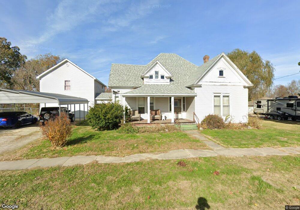
109 N Chestnut St Richland, MO 65556
Estimated Value: $185,000 - $220,654
2
Beds
1
Bath
1,476
Sq Ft
$140/Sq Ft
Est. Value
About This Home
This home is located at 109 N Chestnut St, Richland, MO 65556 and is currently estimated at $205,914, approximately $139 per square foot. 109 N Chestnut St is a home located in Pulaski County with nearby schools including Richland Elementary School, Richland Jr. High School, and Richland High School.
Ownership History
Date
Name
Owned For
Owner Type
Purchase Details
Closed on
Jan 19, 2018
Sold by
Stovall Christopher and Stovall Denise
Bought by
Shaw Adam and Shaw Mona
Current Estimated Value
Home Financials for this Owner
Home Financials are based on the most recent Mortgage that was taken out on this home.
Original Mortgage
$48,000
Outstanding Balance
$24,997
Interest Rate
3.94%
Mortgage Type
New Conventional
Estimated Equity
$180,917
Purchase Details
Closed on
May 26, 2011
Sold by
Jackson Agnes V
Bought by
Stovall Christopher and Stovall Denise
Create a Home Valuation Report for This Property
The Home Valuation Report is an in-depth analysis detailing your home's value as well as a comparison with similar homes in the area
Home Values in the Area
Average Home Value in this Area
Purchase History
| Date | Buyer | Sale Price | Title Company |
|---|---|---|---|
| Shaw Adam | -- | -- | |
| Stovall Christopher | -- | -- |
Source: Public Records
Mortgage History
| Date | Status | Borrower | Loan Amount |
|---|---|---|---|
| Open | Shaw Adam | $48,000 |
Source: Public Records
Tax History Compared to Growth
Tax History
| Year | Tax Paid | Tax Assessment Tax Assessment Total Assessment is a certain percentage of the fair market value that is determined by local assessors to be the total taxable value of land and additions on the property. | Land | Improvement |
|---|---|---|---|---|
| 2024 | $1,113 | $25,795 | $2,725 | $23,070 |
| 2023 | $1,108 | $25,795 | $2,725 | $23,070 |
| 2022 | $1,080 | $25,703 | $2,725 | $22,978 |
| 2021 | $1,090 | $25,703 | $2,725 | $22,978 |
| 2020 | $1,051 | $24,609 | $0 | $0 |
| 2019 | $1,049 | $24,609 | $0 | $0 |
| 2018 | $1,048 | $24,609 | $0 | $0 |
| 2017 | $1,056 | $24,609 | $0 | $0 |
| 2016 | $1,043 | $24,510 | $0 | $0 |
| 2015 | -- | $24,510 | $0 | $0 |
| 2014 | $237 | $24,510 | $0 | $0 |
Source: Public Records
Map
Nearby Homes
- 23013 Rock Bluff Dr
- 23288 Rock Bluff Dr
- 200 Mildred St
- 402 N Chestnut St
- 504 N Pine St
- 605 W Washington Ave
- 304 Warren St
- 815 N Pine St
- 000 Missouri 7
- 907 Belshe Ave
- 218 Francis St
- 704 Ogle Dr
- 501 Hillvale Ave
- 501 Hillvale Dr
- 104 E Jefferson Ave
- 608 Cedar St
- 709 Dublin Ln
- 34990 S Highway 133
- 22798 River View Dr
- 26287 Radcliff Dr
- 105 N Chestnut St
- 112 N Chestnut St
- 112 Chesnut
- 3 Different Houses
- 202 W Washington Ave
- 210 W Washington Ave
- 304 W Washington Ave
- 106 N Chestnut St
- 205 W Jefferson Ave
- 23589 Rock Bluff Dr
- 207 W Washington Ave
- 207 W Washington Ave
- 107 W Jefferson Ave
- 108 W National St
- 301 W Washington Ave
- 107 S Walnut St
- 107 W Washington Ave
- 201 N Pine St
- 205 N Pine St
- 0 Route 7