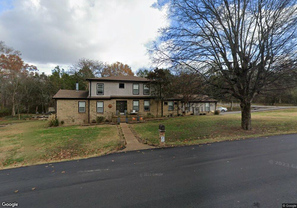
109 Pascal Dr Mount Juliet, TN 37122
Estimated Value: $576,000 - $842,000
Studio
3
Baths
3,582
Sq Ft
$187/Sq Ft
Est. Value
About This Home
This home is located at 109 Pascal Dr, Mount Juliet, TN 37122 and is currently estimated at $670,161, approximately $187 per square foot. 109 Pascal Dr is a home located in Wilson County with nearby schools including Mt. Juliet Elementary School, Mt. Juliet Middle School, and Green Hill High School.
Ownership History
Date
Name
Owned For
Owner Type
Purchase Details
Closed on
Aug 30, 2006
Sold by
Juli Schumann
Bought by
Richard Minchey
Current Estimated Value
Home Financials for this Owner
Home Financials are based on the most recent Mortgage that was taken out on this home.
Original Mortgage
$252,700
Outstanding Balance
$148,602
Interest Rate
6.67%
Estimated Equity
$521,559
Purchase Details
Closed on
Oct 15, 2004
Sold by
First Choice Investments I
Bought by
Juli Schumann
Purchase Details
Closed on
Dec 9, 2003
Sold by
Bank One
Bought by
First Choice Investments
Purchase Details
Closed on
Jan 19, 2001
Sold by
Wallace April L
Bought by
Woods George A
Purchase Details
Closed on
Aug 31, 1989
Bought by
Wallace April Lynn
Purchase Details
Closed on
May 14, 1987
Bought by
Mcintosh Wayne A
Purchase Details
Closed on
Apr 15, 1983
Bought by
Russell William
Purchase Details
Closed on
Dec 15, 1978
Create a Home Valuation Report for This Property
The Home Valuation Report is an in-depth analysis detailing your home's value as well as a comparison with similar homes in the area
Home Values in the Area
Average Home Value in this Area
Purchase History
| Date | Buyer | Sale Price | Title Company |
|---|---|---|---|
| Richard Minchey | $266,000 | -- | |
| Juli Schumann | -- | -- | |
| First Choice Investments | $139,900 | -- | |
| Woods George A | -- | -- | |
| Wallace April Lynn | $118,100 | -- | |
| Mcintosh Wayne A | -- | -- | |
| Russell William | -- | -- | |
| -- | -- | -- |
Source: Public Records
Mortgage History
| Date | Status | Borrower | Loan Amount |
|---|---|---|---|
| Open | Not Available | $252,700 |
Source: Public Records
Tax History
| Year | Tax Paid | Tax Assessment Tax Assessment Total Assessment is a certain percentage of the fair market value that is determined by local assessors to be the total taxable value of land and additions on the property. | Land | Improvement |
|---|---|---|---|---|
| 2025 | $319 | $110,075 | $21,250 | $88,825 |
| 2024 | $2,101 | $110,075 | $21,250 | $88,825 |
| 2022 | $2,100 | $110,000 | $21,250 | $88,750 |
| 2021 | $2,221 | $110,000 | $21,250 | $88,750 |
| 2020 | $2,099 | $110,000 | $21,250 | $88,750 |
| 2019 | $260 | $78,175 | $16,250 | $61,925 |
| 2018 | $2,099 | $78,175 | $16,250 | $61,925 |
| 2017 | $2,099 | $78,175 | $16,250 | $61,925 |
| 2016 | $2,099 | $78,175 | $16,250 | $61,925 |
| 2015 | $2,166 | $78,175 | $16,250 | $61,925 |
| 2014 | $1,975 | $71,278 | $0 | $0 |
Source: Public Records
Map
Nearby Homes
- 110 Pascal Dr
- 115 Pascal Dr
- 1520 Brookstone Cir
- 506 Page Dr
- 1671 W Wilson Blvd
- 1206 Walden Place
- 1202 Mount Vernon Ln
- 2001 Lynnhaven Ct
- 1036 Kelsey Glen Dr
- 3107 Oxford Dr
- 1310 Queensland Way
- 211 Forrest Lawn Dr
- 1408 Tasmania Ct
- 4046 Ethan Ave
- 144 W Division St
- 102 Hickory Trace
- 3012 Brisbane Dr
- 2010 Alice Springs Ct
- 1107 Sydney Terrace
- 2428 Keeling Dr
- 2120 Brookstone Dr
- 2118 Brookstone Dr
- 107 Pascal Dr
- 2400 Brookstone Place
- 2116 Brookstone Dr
- 2119 Brookstone Dr
- 111 Pascal Dr
- 112 Pascal Dr
- 108 Pascal Dr
- 2117 Brookstone Dr
- 2402 Brookstone Place
- 2114 Brookstone Dr
- 105 Pascal Dr
- 2300 Brookstone Ct
- 106 Pascal Dr
- 2302 Brookstone Ct
- 2404 Brookstone Place
- 114 Pascal Dr
- 103 Pascal Dr
- 113 Pascal Dr
Your Personal Tour Guide
Ask me questions while you tour the home.