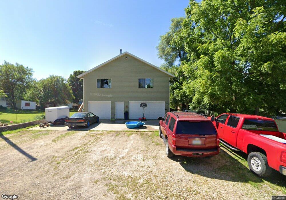
109 W Cedar St Anamosa, IA 52205
Estimated Value: $146,000 - $339,000
1
Bed
1
Bath
832
Sq Ft
$314/Sq Ft
Est. Value
About This Home
This home is located at 109 W Cedar St, Anamosa, IA 52205 and is currently estimated at $261,474, approximately $314 per square foot. 109 W Cedar St is a home located in Jones County with nearby schools including Strawberry Hill Elementary School, Anamosa Middle School, and Anamosa High School.
Ownership History
Date
Name
Owned For
Owner Type
Purchase Details
Closed on
Jan 24, 2017
Sold by
Heser Patrick F and Lindsey Heser Connnie
Bought by
Banks Derek J and Banks Marguerite A
Current Estimated Value
Home Financials for this Owner
Home Financials are based on the most recent Mortgage that was taken out on this home.
Original Mortgage
$148,000
Outstanding Balance
$120,187
Interest Rate
3.62%
Mortgage Type
New Conventional
Estimated Equity
$141,287
Create a Home Valuation Report for This Property
The Home Valuation Report is an in-depth analysis detailing your home's value as well as a comparison with similar homes in the area
Home Values in the Area
Average Home Value in this Area
Purchase History
| Date | Buyer | Sale Price | Title Company |
|---|---|---|---|
| Banks Derek J | $185,000 | None Available |
Source: Public Records
Mortgage History
| Date | Status | Borrower | Loan Amount |
|---|---|---|---|
| Open | Banks Derek J | $148,000 |
Source: Public Records
Tax History Compared to Growth
Tax History
| Year | Tax Paid | Tax Assessment Tax Assessment Total Assessment is a certain percentage of the fair market value that is determined by local assessors to be the total taxable value of land and additions on the property. | Land | Improvement |
|---|---|---|---|---|
| 2025 | $4,576 | $261,810 | $9,090 | $252,720 |
| 2024 | $4,576 | $252,550 | $9,090 | $243,460 |
| 2023 | $4,524 | $252,550 | $9,090 | $243,460 |
| 2022 | $4,064 | $208,920 | $9,090 | $199,830 |
| 2021 | $4,064 | $208,920 | $9,090 | $199,830 |
| 2020 | $3,834 | $191,540 | $9,090 | $182,450 |
| 2019 | $1,636 | $191,540 | $9,090 | $182,450 |
| 2018 | $1,570 | $83,610 | $15,620 | $67,990 |
| 2017 | $1,782 | $83,610 | $15,620 | $67,990 |
| 2016 | $1,754 | $83,610 | $0 | $0 |
| 2015 | $1,754 | $80,820 | $0 | $0 |
| 2014 | $1,786 | $80,820 | $0 | $0 |
Source: Public Records
Map
Nearby Homes
- 605 W Main St
- 105 N High St
- 500 E Hickory St
- 100 E 1st St
- 205 S Ford St
- 219 N Ford St
- 204 N Huber St
- 608 S Garnavillo St
- 207 N Davis St
- 114 Therese Ave
- 121 N Sales Ave
- 302 N Pratt St
- 304 E Plum St
- 105 N Division St
- 23083 County Road E34 Unit Lot 1
- 501 N Division St
- 109 S Dubuque St
- 227th Ave and E-34
- 103 N Oak St
- 1007 Maquoketa St
- 121 Locust St
- 203 Locust St
- 116 W Walnut St
- 118 W Walnut St
- 114 W Walnut St
- 102 W Cedar St
- 102 W Cedar St
- 201 Locust St
- 201 Locust St Unit 1-4
- 112 W Walnut St
- 110 W Walnut St
- 200 W Cedar St
- 204 Locust St
- 108 W Walnut St
- 117 W Walnut St
- 111 W Walnut St
- 115 W Walnut St
- 200 W Walnut St
- 109 W Walnut St
- 106 W Walnut St