Estimated Value: $620,033 - $704,000
4
Beds
3
Baths
2,480
Sq Ft
$270/Sq Ft
Est. Value
About This Home
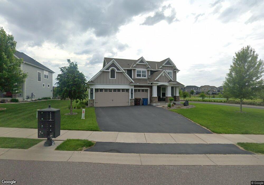
This home is located at 10995 Cattail Path, Osseo, MN 55369 and is currently estimated at $669,758, approximately $270 per square foot. 10995 Cattail Path is a home located in Hennepin County with nearby schools including Fernbrook Elementary School, Osseo Middle School, and Maple Grove Senior High School.
Ownership History
Date
Name
Owned For
Owner Type
Purchase Details
Closed on
Mar 17, 2017
Sold by
Rustad Seanath and Rustad Jessica
Bought by
Dombrowski Lynn
Current Estimated Value
Home Financials for this Owner
Home Financials are based on the most recent Mortgage that was taken out on this home.
Original Mortgage
$413,250
Outstanding Balance
$342,879
Interest Rate
4.19%
Mortgage Type
New Conventional
Estimated Equity
$326,879
Purchase Details
Closed on
Nov 13, 2015
Sold by
U S Home Corporation
Bought by
Rustad Seanathon and Rustad Jessica
Home Financials for this Owner
Home Financials are based on the most recent Mortgage that was taken out on this home.
Original Mortgage
$402,733
Interest Rate
3.82%
Mortgage Type
New Conventional
Purchase Details
Closed on
Sep 29, 2014
Create a Home Valuation Report for This Property
The Home Valuation Report is an in-depth analysis detailing your home's value as well as a comparison with similar homes in the area
Home Values in the Area
Average Home Value in this Area
Purchase History
| Date | Buyer | Sale Price | Title Company |
|---|---|---|---|
| Dombrowski Lynn | $435,000 | None Available | |
| Rustad Seanathon | $423,929 | North American Title Company | |
| -- | $3,343,500 | -- |
Source: Public Records
Mortgage History
| Date | Status | Borrower | Loan Amount |
|---|---|---|---|
| Open | Dombrowski Lynn | $413,250 | |
| Previous Owner | Rustad Seanathon | $402,733 |
Source: Public Records
Tax History Compared to Growth
Tax History
| Year | Tax Paid | Tax Assessment Tax Assessment Total Assessment is a certain percentage of the fair market value that is determined by local assessors to be the total taxable value of land and additions on the property. | Land | Improvement |
|---|---|---|---|---|
| 2024 | $7,262 | $561,200 | $125,000 | $436,200 |
| 2023 | $7,117 | $558,900 | $120,000 | $438,900 |
| 2022 | $6,188 | $536,000 | $130,000 | $406,000 |
| 2021 | $6,208 | $451,000 | $102,000 | $349,000 |
| 2020 | $6,460 | $434,000 | $95,000 | $339,000 |
| 2019 | $6,605 | $428,000 | $100,000 | $328,000 |
| 2018 | $6,835 | $419,000 | $100,000 | $319,000 |
| 2017 | $6,229 | $386,000 | $95,000 | $291,000 |
| 2016 | $969 | $48,600 | $48,600 | $0 |
| 2015 | $436 | $21,400 | $21,400 | $0 |
Source: Public Records
Map
Nearby Homes
- 15160 109th Ave N
- 15261 110th Ave N
- 15351 110th Ave N
- 15171 110th Ave N
- 15161 110th Ave N
- 15350 110th Ave N
- 11057 Kingsview Ln N
- 15440 110th Ave N
- 10763 Orchid Ln N
- 11168 Kingsview Ln N
- 11158 Kingsview Ln N
- 11227 N Kingsview Ln N
- 11290 Niagara Ln N
- Elmwood IV Plan at Sundance Greens
- Hillcrest Plan at Sundance Greens
- Cedarwood II Plan at Sundance Greens
- Grayson Plan at Sundance Greens
- Magnolia Plan at Sundance Greens
- Ivy Plan at Sundance Greens
- Alpine Plan at Sundance Greens
- 13999 11021 Cattail Path Ave N
- 13985 11021 Cattail Path Ave N
- 10951 Cattail Path
- 15230 Creekside Ln
- 10990 Cattail Path
- 15250 Creekside Ln
- 11021 Cattail Path
- 10980 Cattail Path
- 11000 Cattail Path
- 15211 Creekside Ln
- 11010 Cattail Path
- 15270 Creekside Ln
- 15231 Creekside Ln
- 10970 Cattail Path
- 10970 Cattail Path
- 10950 Cattail Path
- 15250 15250 Creekside Ln
- 15251 Creekside Ln
- 10970 Sundance Woods Blvd
- 10960 Cattail Path