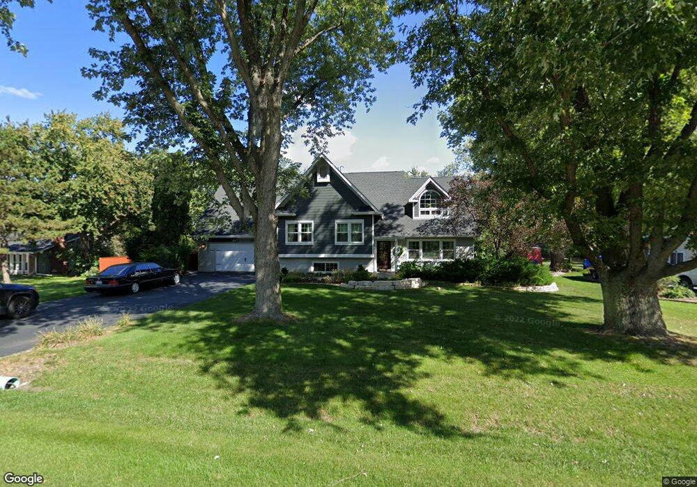
10S075 Ridge Rd Naperville, IL 60565
Springbrook Prairie NeighborhoodEstimated Value: $533,520 - $674,000
--
Bed
1
Bath
2,218
Sq Ft
$270/Sq Ft
Est. Value
About This Home
This home is located at 10S075 Ridge Rd, Naperville, IL 60565 and is currently estimated at $598,130, approximately $269 per square foot. 10S075 Ridge Rd is a home located in Will County with nearby schools including Robert Clow Elementary School, Ellsworth Elementary School, and Gordon Gregory Middle School.
Ownership History
Date
Name
Owned For
Owner Type
Purchase Details
Closed on
Mar 12, 2024
Sold by
Barnes Steven J and Barnes Dana L
Bought by
Steven And Dana Barnes Joint Trust and Barnes
Current Estimated Value
Purchase Details
Closed on
Apr 25, 2020
Sold by
Barnes Steven J and Barnes Dana L
Bought by
Barnes Steven J and Barnes Dana L
Home Financials for this Owner
Home Financials are based on the most recent Mortgage that was taken out on this home.
Original Mortgage
$555,000
Interest Rate
2.98%
Mortgage Type
FHA
Purchase Details
Closed on
Dec 1, 2010
Sold by
Barnes J Beverley and Beverley Barnes Declaration J
Bought by
Barnes Steven J
Purchase Details
Closed on
Jul 21, 2003
Sold by
The Northern Trust Co
Bought by
J Beverly Barnes Trust
Purchase Details
Closed on
Dec 24, 1997
Sold by
Ward Brendan B and Case #96 Ch 12814
Bought by
Northern Trust Co and Trust #9484
Create a Home Valuation Report for This Property
The Home Valuation Report is an in-depth analysis detailing your home's value as well as a comparison with similar homes in the area
Home Values in the Area
Average Home Value in this Area
Purchase History
| Date | Buyer | Sale Price | Title Company |
|---|---|---|---|
| Steven And Dana Barnes Joint Trust | -- | None Listed On Document | |
| Barnes Steven J | -- | National Title Solutions Inc | |
| Barnes Steven J | -- | C T I-W | |
| J Beverly Barnes Trust | -- | Chicago Title Insurance Co | |
| Northern Trust Co | -- | -- |
Source: Public Records
Mortgage History
| Date | Status | Borrower | Loan Amount |
|---|---|---|---|
| Previous Owner | Barnes Steven J | $555,000 |
Source: Public Records
Tax History Compared to Growth
Tax History
| Year | Tax Paid | Tax Assessment Tax Assessment Total Assessment is a certain percentage of the fair market value that is determined by local assessors to be the total taxable value of land and additions on the property. | Land | Improvement |
|---|---|---|---|---|
| 2024 | $10,194 | $178,507 | $25,941 | $152,566 |
| 2023 | $10,194 | $157,692 | $22,916 | $134,776 |
| 2022 | $9,858 | $149,188 | $21,679 | $127,509 |
| 2021 | $8,558 | $142,084 | $20,647 | $121,437 |
| 2020 | $8,519 | $139,833 | $20,320 | $119,513 |
| 2019 | $8,236 | $135,892 | $19,747 | $116,145 |
| 2018 | $6,999 | $108,333 | $23,065 | $85,268 |
| 2017 | $6,904 | $105,537 | $22,470 | $83,067 |
| 2016 | $6,358 | $95,825 | $21,986 | $73,839 |
| 2015 | -- | $92,139 | $21,140 | $70,999 |
| 2014 | -- | $92,139 | $21,140 | $70,999 |
| 2013 | -- | $92,139 | $21,140 | $70,999 |
Source: Public Records
Map
Nearby Homes
- 567 Roxbury Dr
- 2224 Flambeau Dr
- 2206 Gleneagles Dr
- 1321 Galena Ct
- 2301 Mecan Dr
- 1329 Neskola Ct
- 1134 Gateshead Dr
- 445 Travelaire Ave
- 1305 Morningstar Ct Unit 1A
- 28W555 Leverenz Rd
- 2741 Gateshead Dr
- 343 Danbury Dr Unit 6B
- 2636 Salix Cir
- 1123 Thackery Ln
- 284 Westbrook Cir
- 2167 Countryside Cir
- 2734 Alyssa Dr
- 3004 Bennett Dr
- 240 Westbrook Cir
- 303 Cedarbrook Rd
- 10S071 Ridge Rd
- 10S071 Ridge Rd
- 10S107 Ridge Rd
- 10S090 Springbrook Dr
- 10S108 Springbrook Dr
- 10S072 Springbrook Dr
- 10S090 Ridge Rd
- 10S125 Ridge Rd
- 10S120 Ridge Rd Unit 2
- 10S072 Ridge Rd Unit 2
- 10s Valley Ridge Ct
- 1960 Springbrook Dr Unit 104
- 10S126 Springbrook Dr
- 10S126 Ridge Rd
- 10S159 Ridge Rd
- 10 Ridge Rd
- 10S089 Springbrook Dr
- 10S144 Springbrook Dr
- 10S107 Springbrook Dr
- 10S071 Springbrook Dr