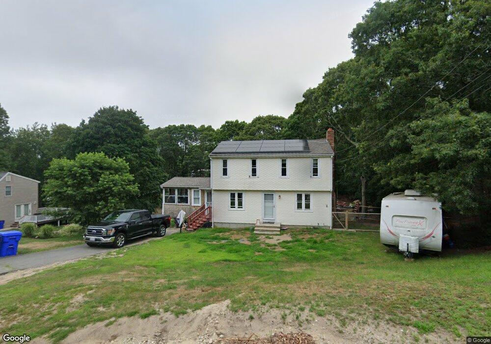
11 Colony Ave Bourne, MA 2532
Estimated Value: $508,391 - $554,000
3
Beds
2
Baths
1,260
Sq Ft
$423/Sq Ft
Est. Value
About This Home
This home is located at 11 Colony Ave, Bourne, MA 2532 and is currently estimated at $533,098, approximately $423 per square foot. 11 Colony Ave is a home located in Barnstable County with nearby schools including Bourne High School, Cadence Academy Preschool - Bourne, and St Margaret Regional School.
Ownership History
Date
Name
Owned For
Owner Type
Purchase Details
Closed on
Aug 26, 2004
Sold by
Mulhern Maureen
Bought by
Maressa Joan E
Current Estimated Value
Purchase Details
Closed on
Jul 15, 1999
Sold by
Robinson Daniel E and Robinson Bernadette F
Bought by
Mulhern Maureen
Purchase Details
Closed on
May 30, 1997
Sold by
Robinson Harold E and Robinson Ruth J
Bought by
Robinson Daniel E and Robinson Bernadette F
Purchase Details
Closed on
Apr 20, 1988
Sold by
Gipps Rogers S
Bought by
Robinson Harold E
Create a Home Valuation Report for This Property
The Home Valuation Report is an in-depth analysis detailing your home's value as well as a comparison with similar homes in the area
Purchase History
| Date | Buyer | Sale Price | Title Company |
|---|---|---|---|
| Maressa Joan E | $302,000 | -- | |
| Maressa Joan E | $302,000 | -- | |
| Mulhern Maureen | $145,000 | -- | |
| Mulhern Maureen | $145,000 | -- | |
| Robinson Daniel E | $106,250 | -- | |
| Robinson Daniel E | $106,250 | -- | |
| Robinson Harold E | $115,000 | -- |
Source: Public Records
Mortgage History
| Date | Status | Borrower | Loan Amount |
|---|---|---|---|
| Previous Owner | Robinson Harold E | $147,500 | |
| Previous Owner | Robinson Harold E | $20,000 |
Source: Public Records
Tax History
| Year | Tax Paid | Tax Assessment Tax Assessment Total Assessment is a certain percentage of the fair market value that is determined by local assessors to be the total taxable value of land and additions on the property. | Land | Improvement |
|---|---|---|---|---|
| 2025 | $3,264 | $417,900 | $184,900 | $233,000 |
| 2024 | $3,190 | $397,800 | $176,000 | $221,800 |
| 2023 | $3,124 | $354,600 | $155,800 | $198,800 |
| 2022 | $2,984 | $295,700 | $137,900 | $157,800 |
| 2021 | $0 | $269,200 | $125,500 | $143,700 |
| 2020 | $2,804 | $261,100 | $124,300 | $136,800 |
| 2019 | $2,663 | $253,400 | $124,300 | $129,100 |
| 2018 | $2,543 | $241,300 | $118,400 | $122,900 |
| 2017 | $20,950 | $222,200 | $111,400 | $110,800 |
| 2016 | $2,234 | $219,900 | $111,400 | $108,500 |
| 2015 | $2,097 | $208,200 | $99,700 | $108,500 |
Source: Public Records
Map
Nearby Homes
- 20 Colony Ave
- 4 Harbor Hill Dr
- 16 Amberwood Ct
- 12 Turnberry Rd Unit 12
- 203 County Rd
- 4 Hollyhock Knoll Ct Unit 4
- 4 Hollyhock Knoll Ct Unit 4
- 5 Sea Knoll Ct
- 13 Laurel Hill Ct
- 566 Shore Rd
- 3 1st St
- 709 County Rd
- 7 4th Ave
- 3 4th Ave
- 5 Zoli Ln
- 254 Barlows Landing Rd
- 44 Cotuit Rd
- 16 Michael Rd
- 14 Navajo Rd
- 10 Sandy Ln
Your Personal Tour Guide
Ask me questions while you tour the home.