
Seller's Agent in 2025
Laurie Norton Team
BHG Masiello Bedford
(603) 361-4804
34 in this area
481 Total Sales

Estimated Value: $839,000 - $896,000
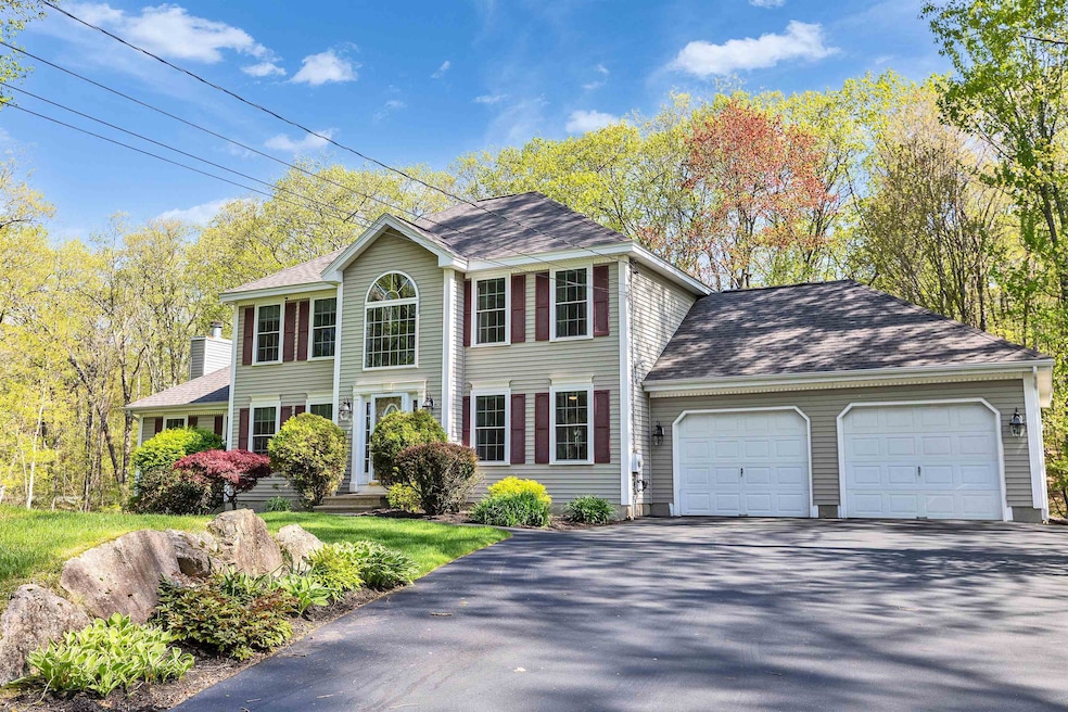
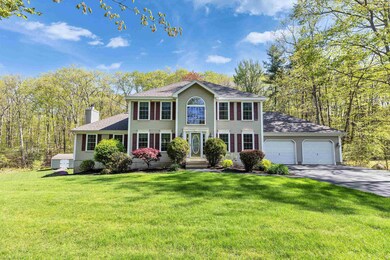
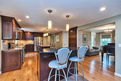
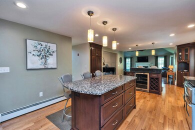
Beautifully appointed 3BR, 3BA Colonial located in one of the area’s most desirable neighborhoods, offering easy access to highways, shopping, and everyday conveniences.
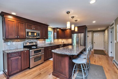
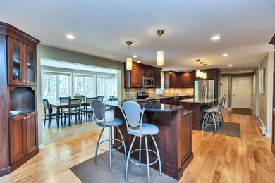
Spacious, open-concept layout featuring a large kitchen with center island, separate breakfast bar, and wine fridge—perfect for entertaining. The bright and sunny dining room flows seamlessly from the kitchen. A full-season sunroom provides a tranquil retreat, overlooking the back and side yard. A dedicated office with custom built-ins makes working from home a pleasure. Upstairs, you’ll find three generously sized bedrooms, including a unique bonus room with French doors and cathedral ceiling—ideal as a playroom, studio, or second office. The finished basement offers space for a full home gym, potential for an additional bedroom complete with its own walk-in closet—perfect for guests or extended family. Enjoy summer days in your private, fenced-in yard with in-ground pool and ample space for outdoor living. This home blends comfort, functionality, and style in a prime location—don’t miss this rare opportunity!
Last Agent to Sell the Property
BHG Masiello Bedford License #058926 Listed on: 05/14/2025
| Date | Buyer | Sale Price | Title Company |
|---|---|---|---|
| Learnard Johanna | $850,000 | None Available | |
| Learnard Johanna | $850,000 | None Available | |
| Marx Donna | -- | -- | |
| Marx Donna | -- | -- | |
| Marx Peter D | $215,000 | -- | |
| Marx Peter D | $215,000 | -- |
| Date | Status | Borrower | Loan Amount |
|---|---|---|---|
| Open | Learnard Johanna | $485,000 | |
| Closed | Learnard Johanna | $485,000 | |
| Previous Owner | Marx Peter D | $172,000 |
| Date | Event | Price | List to Sale | Price per Sq Ft |
|---|---|---|---|---|
| 06/25/2025 06/25/25 | Sold | $850,000 | -2.9% | $218 / Sq Ft |
| 06/17/2025 06/17/25 | Pending | -- | -- | -- |
| 05/14/2025 05/14/25 | For Sale | $875,000 | -- | $224 / Sq Ft |
| Year | Tax Paid | Tax Assessment Tax Assessment Total Assessment is a certain percentage of the fair market value that is determined by local assessors to be the total taxable value of land and additions on the property. | Land | Improvement |
|---|---|---|---|---|
| 2024 | $14,068 | $829,500 | $165,700 | $663,800 |
| 2023 | $13,255 | $829,500 | $165,700 | $663,800 |
| 2022 | $11,320 | $470,700 | $112,500 | $358,200 |
| 2021 | $10,459 | $470,700 | $112,500 | $358,200 |
| 2020 | $10,595 | $470,700 | $112,500 | $358,200 |
| 2019 | $10,144 | $470,700 | $112,500 | $358,200 |
| 2018 | $10,412 | $470,700 | $112,500 | $358,200 |
| 2017 | $10,351 | $387,100 | $98,700 | $288,400 |
| 2016 | $10,216 | $387,100 | $98,700 | $288,400 |
| 2015 | $2,602 | $387,100 | $98,700 | $288,400 |
| 2014 | $1,304 | $387,100 | $98,700 | $288,400 |
| 2013 | -- | $387,100 | $98,700 | $288,400 |
Seller's Agent in 2025
Laurie Norton Team
BHG Masiello Bedford
(603) 361-4804
34 in this area
481 Total Sales
Buyer's Agent in 2025
Christine Tatro
EXP Realty
(603) 738-3000
6 in this area
187 Total Sales
Source: PrimeMLS
MLS Number: 5040800
APN: HOOK-000048-000076-000030
Disclaimer: Certain information contained herein is derived from information provided by parties other than Homes.com. All information provided is deemed reliable, but is not guaranteed to be accurate and should be independently verified.
![]() Copyright 2026 PrimeMLS, Inc. All rights reserved. This information is deemed reliable, but not guaranteed. The data relating to real estate displayed on this display comes in part from the IDX Program of PrimeMLS. The information being provided is for consumers’ personal, non-commercial use and may not be used for any purpose other than to identify prospective properties consumers may be interested in purchasing.
Copyright 2026 PrimeMLS, Inc. All rights reserved. This information is deemed reliable, but not guaranteed. The data relating to real estate displayed on this display comes in part from the IDX Program of PrimeMLS. The information being provided is for consumers’ personal, non-commercial use and may not be used for any purpose other than to identify prospective properties consumers may be interested in purchasing.
Ask me questions while you tour the home.