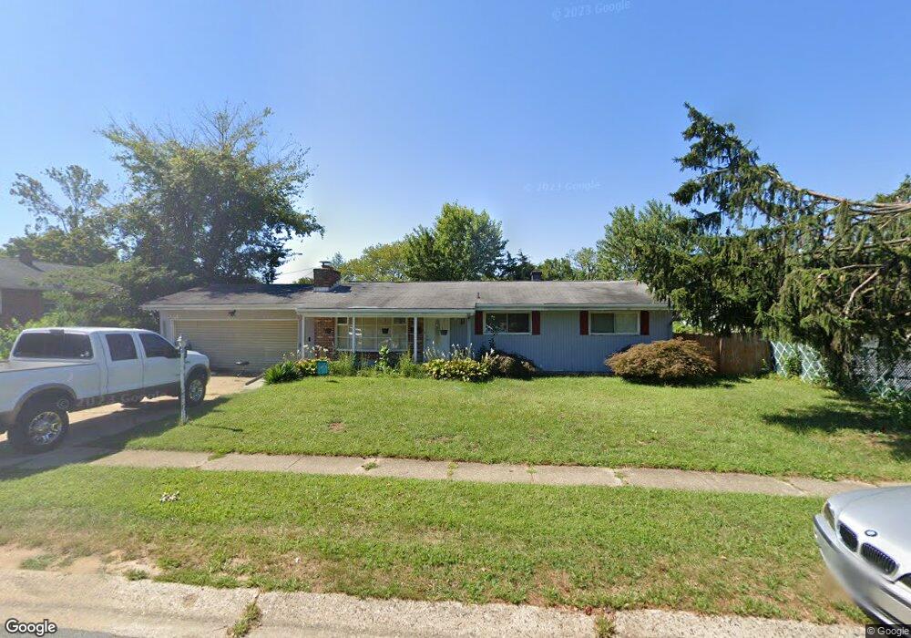
11 Mattei Ln Newark, DE 19713
Estimated Value: $302,000 - $322,914
3
Beds
1
Bath
1,148
Sq Ft
$275/Sq Ft
Est. Value
About This Home
This home is located at 11 Mattei Ln, Newark, DE 19713 and is currently estimated at $315,479, approximately $274 per square foot. 11 Mattei Ln is a home located in New Castle County with nearby schools including Brookside Elementary School, Kirk (George V.) Middle School, and Newark High School.
Ownership History
Date
Name
Owned For
Owner Type
Purchase Details
Closed on
Dec 27, 2001
Sold by
Campbell Griff
Bought by
Stollings John J and Stollings Michelle L
Current Estimated Value
Home Financials for this Owner
Home Financials are based on the most recent Mortgage that was taken out on this home.
Original Mortgage
$123,920
Outstanding Balance
$49,088
Interest Rate
6.61%
Mortgage Type
FHA
Estimated Equity
$266,391
Create a Home Valuation Report for This Property
The Home Valuation Report is an in-depth analysis detailing your home's value as well as a comparison with similar homes in the area
Home Values in the Area
Average Home Value in this Area
Purchase History
| Date | Buyer | Sale Price | Title Company |
|---|---|---|---|
| Stollings John J | $124,900 | -- |
Source: Public Records
Mortgage History
| Date | Status | Borrower | Loan Amount |
|---|---|---|---|
| Open | Stollings John J | $123,920 |
Source: Public Records
Tax History Compared to Growth
Tax History
| Year | Tax Paid | Tax Assessment Tax Assessment Total Assessment is a certain percentage of the fair market value that is determined by local assessors to be the total taxable value of land and additions on the property. | Land | Improvement |
|---|---|---|---|---|
| 2024 | $2,169 | $50,800 | $8,900 | $41,900 |
| 2023 | $2,109 | $50,800 | $8,900 | $41,900 |
| 2022 | $2,104 | $50,800 | $8,900 | $41,900 |
| 2021 | $2,060 | $50,800 | $8,900 | $41,900 |
| 2020 | $2,006 | $50,800 | $8,900 | $41,900 |
| 2019 | $2,221 | $50,800 | $8,900 | $41,900 |
| 2018 | $1,728 | $50,800 | $8,900 | $41,900 |
| 2017 | $1,667 | $50,800 | $8,900 | $41,900 |
| 2016 | $1,662 | $50,800 | $8,900 | $41,900 |
| 2015 | $1,516 | $50,800 | $8,900 | $41,900 |
| 2014 | $1,514 | $50,800 | $8,900 | $41,900 |
Source: Public Records
Map
Nearby Homes
- 183 Brookside Blvd
- 4 Martell Rd
- 42 Lynch Farm Dr
- 3 Matthews Rd
- 107 Anderson Rd
- 620 Ilse Dr
- 13 Erskine Ct
- 120 Hopkins Ct
- 21 Merion Rd
- 28 W Stephen Dr
- 886 Broadfield Dr
- 11 Palmer Place
- 40 E Shady Dr
- 18 Malvina Ln
- 1401 Chelmsford Cir Unit 1401
- 48 Chippendale Cir
- 59 E Shady Dr
- 1200 Chelmsford Cir
- 2 Augusta Dr
- 9 E Village Rd Unit 9