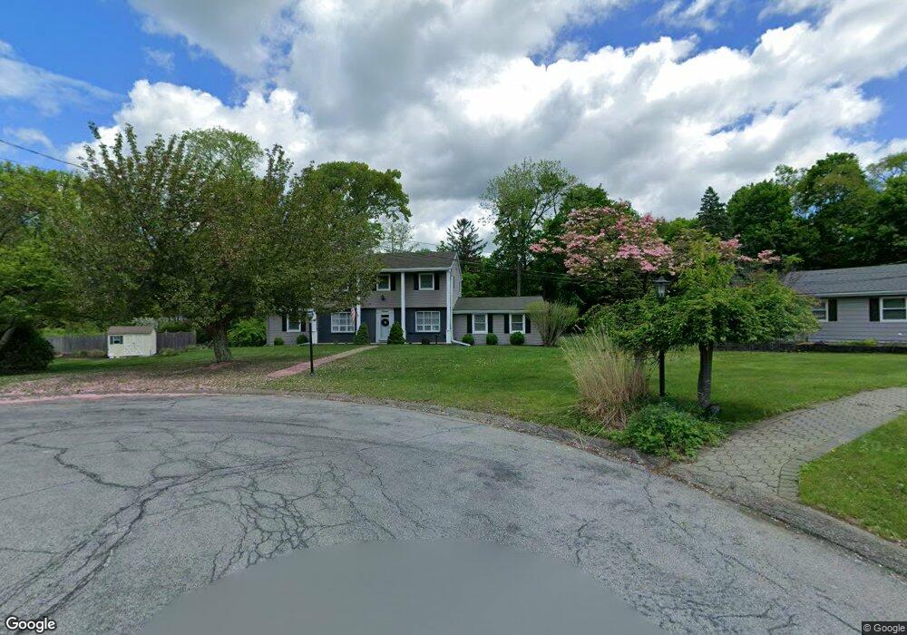
11 Mildred Dr Sparta, NJ 07871
Estimated Value: $499,500 - $668,000
--
Bed
--
Bath
1,851
Sq Ft
$310/Sq Ft
Est. Value
About This Home
This home is located at 11 Mildred Dr, Sparta, NJ 07871 and is currently estimated at $574,125, approximately $310 per square foot. 11 Mildred Dr is a home located in Sussex County with nearby schools including Sparta High School, Alpine Montessori - Sparta, and Hilltop Country Day School.
Ownership History
Date
Name
Owned For
Owner Type
Purchase Details
Closed on
Mar 18, 1994
Sold by
Mclaughlin Rita E
Bought by
Ackerman Keith D and Ackerman Elizabeth H
Current Estimated Value
Home Financials for this Owner
Home Financials are based on the most recent Mortgage that was taken out on this home.
Original Mortgage
$172,000
Interest Rate
7.15%
Mortgage Type
VA
Create a Home Valuation Report for This Property
The Home Valuation Report is an in-depth analysis detailing your home's value as well as a comparison with similar homes in the area
Home Values in the Area
Average Home Value in this Area
Purchase History
| Date | Buyer | Sale Price | Title Company |
|---|---|---|---|
| Ackerman Keith D | $168,900 | -- |
Source: Public Records
Mortgage History
| Date | Status | Borrower | Loan Amount |
|---|---|---|---|
| Closed | Ackerman Keith D | $172,000 |
Source: Public Records
Tax History Compared to Growth
Tax History
| Year | Tax Paid | Tax Assessment Tax Assessment Total Assessment is a certain percentage of the fair market value that is determined by local assessors to be the total taxable value of land and additions on the property. | Land | Improvement |
|---|---|---|---|---|
| 2025 | $10,397 | $289,700 | $136,200 | $153,500 |
| 2024 | $10,099 | $289,700 | $136,200 | $153,500 |
| 2023 | $10,099 | $289,700 | $136,200 | $153,500 |
| 2022 | $9,856 | $289,700 | $136,200 | $153,500 |
| 2021 | $9,699 | $289,700 | $136,200 | $153,500 |
| 2020 | $9,850 | $289,700 | $136,200 | $153,500 |
| 2019 | $9,595 | $289,700 | $136,200 | $153,500 |
| 2018 | $9,392 | $289,700 | $136,200 | $153,500 |
| 2017 | $9,276 | $289,700 | $136,200 | $153,500 |
| 2016 | $9,059 | $289,700 | $136,200 | $153,500 |
| 2015 | $8,847 | $227,500 | $85,500 | $142,000 |
| 2014 | $8,704 | $227,500 | $85,500 | $142,000 |
Source: Public Records
Map
Nearby Homes
- 10 Mildred Dr
- 7 Hilltop Trail
- 88 Stanhope Rd
- 78 Hunters Ln
- 25 Stanhope Rd
- 11 Abigail Way Unit 31
- 21 Springbrook Trail
- 23 E Shore Trail
- 13 Log Cabin Terrace
- 2 Bell St
- 116 E Shore Trail
- 3 Lakeside Place
- 9 Woodland Trail
- 118 Hilltop Trail
- 8 Saint Marys Place
- 126 Hilltop Trail
- 16 Main St
- 16 Main St Unit D6
- 16 Main St Unit D7
- 57 Park Rd