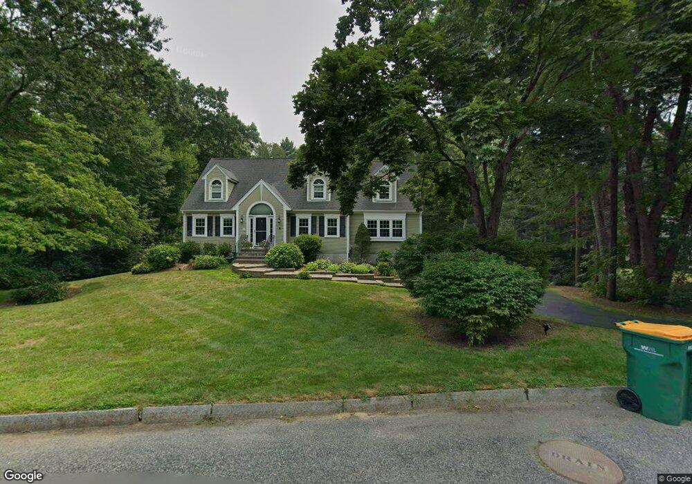
11 Nathan Rd Mansfield, MA 02048
Estimated Value: $876,514 - $1,132,000
5
Beds
3
Baths
2,987
Sq Ft
$326/Sq Ft
Est. Value
About This Home
This home is located at 11 Nathan Rd, Mansfield, MA 02048 and is currently estimated at $974,379, approximately $326 per square foot. 11 Nathan Rd is a home located in Bristol County with nearby schools including Everett W. Robinson Elementary School, Jordan/Jackson Elementary School, and Harold L. Qualters Middle School.
Ownership History
Date
Name
Owned For
Owner Type
Purchase Details
Closed on
Jul 27, 2017
Sold by
Santos David M and Santos Kimberly A
Bought by
Santos Ft
Current Estimated Value
Purchase Details
Closed on
Jun 29, 2011
Sold by
Domurad John Jm
Bought by
Santos David M and Santos Kim A
Home Financials for this Owner
Home Financials are based on the most recent Mortgage that was taken out on this home.
Original Mortgage
$50,000
Interest Rate
4.53%
Purchase Details
Closed on
Jun 29, 1994
Sold by
Harvey Richard Alan and Witz-Harvey Carolyn A
Bought by
Domurad John Jm and Domurad Joan
Purchase Details
Closed on
Aug 15, 1990
Sold by
East Coast Dev Ltd
Bought by
Harvey Richard Alan
Create a Home Valuation Report for This Property
The Home Valuation Report is an in-depth analysis detailing your home's value as well as a comparison with similar homes in the area
Home Values in the Area
Average Home Value in this Area
Purchase History
| Date | Buyer | Sale Price | Title Company |
|---|---|---|---|
| Santos Ft | -- | -- | |
| Santos David M | $528,750 | -- | |
| Domurad John Jm | $271,000 | -- | |
| Harvey Richard Alan | $242,500 | -- |
Source: Public Records
Mortgage History
| Date | Status | Borrower | Loan Amount |
|---|---|---|---|
| Previous Owner | Harvey Richard Alan | $367,000 | |
| Previous Owner | Harvey Richard Alan | $50,000 |
Source: Public Records
Tax History
| Year | Tax Paid | Tax Assessment Tax Assessment Total Assessment is a certain percentage of the fair market value that is determined by local assessors to be the total taxable value of land and additions on the property. | Land | Improvement |
|---|---|---|---|---|
| 2025 | $9,768 | $741,700 | $283,800 | $457,900 |
| 2024 | $10,198 | $755,400 | $296,200 | $459,200 |
| 2023 | $10,029 | $711,800 | $296,200 | $415,600 |
| 2022 | $9,625 | $634,500 | $274,200 | $360,300 |
| 2021 | $9,247 | $602,000 | $228,500 | $373,500 |
| 2020 | $8,817 | $574,000 | $228,500 | $345,500 |
| 2019 | $8,202 | $538,900 | $190,300 | $348,600 |
| 2018 | $7,386 | $520,800 | $181,600 | $339,200 |
| 2017 | $7,247 | $482,500 | $176,500 | $306,000 |
| 2016 | $6,970 | $452,300 | $167,900 | $284,400 |
| 2015 | $6,915 | $446,100 | $167,900 | $278,200 |
Source: Public Records
Map
Nearby Homes
- 14 Windchime Dr
- 19 Barberry Rd
- 571 Ware St
- 0 Cobb St
- 21 Juniper Rd
- 0 Brook Pkwy
- 0 Kensington Rd
- 268 Reservoir St
- 460 Ware St
- 6 Rumford Rd
- 1 Deer Path Ln
- 212 Mill St
- 7 Fieldstone Dr
- 104 Newcomb St Unit E
- 157 Mansfield Ave Unit 14
- 250 Mansfield Ave Unit 11
- 93 Mansfield Ave
- 27 Smith St Unit 11
- 95 Godfrey Dr
- 157 Highland St
Your Personal Tour Guide
Ask me questions while you tour the home.