
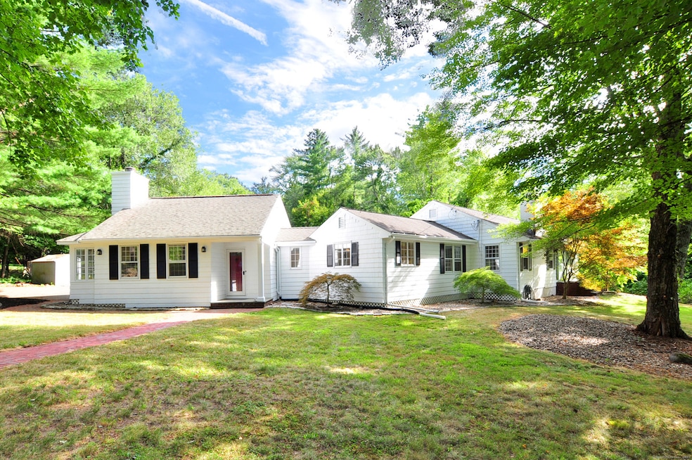


11 Oakhurst Rd Simsbury, CT 06070
West Simsbury NeighborhoodEstimated payment $3,425/month
Total Views
436
3
Beds
2.5
Baths
2,934
Sq Ft
$167
Price per Sq Ft
Highlights
- Very Popular Property
- Deck
- Attic
- Latimer Lane School Rated A
- Ranch Style House
- 2 Fireplaces
About This Home
Beautiful sprawling ranch style home located in lovely Simsbury. This home has been lovingly taken care of for many years and is looking for new owners that will apply a personal touch and style to turn this house into their home. This spacious home is perfect for entertaining family and friends. Large family room with cozy reading nook and fireplace. Great for those chilly evenings in fall and winter. Kitchen with breakfast area and French doors that lead out to a deck. The perfect place for your morning coffee. Large dining room with built-in hutches that leads into a living room with a pellet stove. 3 bedrooms and 2 1/2 baths, an extra room with a closet to be used for an office or of your choosing, laundry area and gleaming hardwood floors complete the main level. The lower level has a finished area of 348 square feet with plenty of closets and storage. Enjoy a spacious, private and peaceful backyard with gorgeous garden areas. Your private Oasis! Freshly painted exterior (8/25), selected rooms on the interior freshly painted (8/25), new deck (8/25) seller owned solar panels and solar water panels, generator ready with generator plus central air and to be sold as is. Conveniently located on a quiet road on the Simsbury/Avon line, shopping restaurants and more! Make an appointment today and see what this beautiful home has to offer. Be prepared to FALL in LOVE with your new HOME!
Listing Agent
Berkshire Hathaway NE Prop. License #REB.0789599 Listed on: 08/23/2025
Home Details
Home Type
- Single Family
Est. Annual Taxes
- $9,134
Year Built
- Built in 1958
Lot Details
- 0.92 Acre Lot
- Garden
- Property is zoned R-40
Home Design
- Ranch Style House
- Concrete Foundation
- Frame Construction
- Shingle Roof
- Shingle Siding
Interior Spaces
- 2 Fireplaces
- French Doors
- Partially Finished Basement
- Partial Basement
- Pull Down Stairs to Attic
Kitchen
- Electric Range
- Dishwasher
Bedrooms and Bathrooms
- 3 Bedrooms
Laundry
- Laundry on main level
- Dryer
- Washer
Parking
- 2 Car Garage
- Parking Deck
- Automatic Garage Door Opener
Eco-Friendly Details
- Solar Water Heater
- Solar Heating System
- Heating system powered by solar not connected to the grid
- Heating system powered by active solar
Outdoor Features
- Deck
- Shed
Location
- Property is near shops
Schools
- Simsbury High School
Utilities
- Central Air
- Window Unit Cooling System
- Heating System Uses Oil
- Programmable Thermostat
- Private Company Owned Well
- Fuel Tank Located in Basement
Listing and Financial Details
- Assessor Parcel Number 699687
Map
Create a Home Valuation Report for This Property
The Home Valuation Report is an in-depth analysis detailing your home's value as well as a comparison with similar homes in the area
Home Values in the Area
Average Home Value in this Area
Tax History
| Year | Tax Paid | Tax Assessment Tax Assessment Total Assessment is a certain percentage of the fair market value that is determined by local assessors to be the total taxable value of land and additions on the property. | Land | Improvement |
|---|---|---|---|---|
| 2025 | $9,134 | $267,400 | $81,200 | $186,200 |
| 2024 | $8,907 | $267,400 | $81,200 | $186,200 |
| 2023 | $8,509 | $267,400 | $81,200 | $186,200 |
| 2022 | $7,923 | $205,090 | $88,200 | $116,890 |
| 2021 | $7,923 | $205,090 | $88,200 | $116,890 |
| 2020 | $7,607 | $205,090 | $88,200 | $116,890 |
| 2019 | $7,654 | $205,090 | $88,200 | $116,890 |
| 2018 | $7,709 | $205,090 | $88,200 | $116,890 |
| 2017 | $7,700 | $198,650 | $88,200 | $110,450 |
| 2016 | $7,374 | $198,650 | $88,200 | $110,450 |
| 2015 | $7,374 | $198,650 | $88,200 | $110,450 |
| 2014 | $7,378 | $198,650 | $88,200 | $110,450 |
Source: Public Records
Property History
| Date | Event | Price | Change | Sq Ft Price |
|---|---|---|---|---|
| 08/25/2025 08/25/25 | For Sale | $489,000 | -- | $167 / Sq Ft |
Source: SmartMLS
Purchase History
| Date | Type | Sale Price | Title Company |
|---|---|---|---|
| Warranty Deed | $399,900 | -- | |
| Warranty Deed | $324,900 | -- |
Source: Public Records
Mortgage History
| Date | Status | Loan Amount | Loan Type |
|---|---|---|---|
| Open | $77,000 | Credit Line Revolving | |
| Open | $218,000 | Stand Alone Refi Refinance Of Original Loan |
Source: Public Records
Similar Homes in the area
Source: SmartMLS
MLS Number: 24119218
APN: SIMS-000016C-000301-000013-003133-839
Disclaimer: Certain information contained herein is derived from information provided by parties other than Homes.com. All information provided is deemed reliable, but is not guaranteed to be accurate and should be independently verified.
![]() IDX information is provided exclusively for personal, non-commercial use, and may not be used for any purpose other than to identify prospective properties consumers may be interested in purchasing. Information is deemed reliable but not guaranteed.
IDX information is provided exclusively for personal, non-commercial use, and may not be used for any purpose other than to identify prospective properties consumers may be interested in purchasing. Information is deemed reliable but not guaranteed.
Nearby Homes
- 302 Bushy Hill Rd
- 21 Stockade Rd
- 5 Hickory Hill Rd
- 274 W Mountain Rd
- 53 Pine Glen Rd
- 14 Crane Place
- 47 Notch Rd
- 15 Butternut Ln
- 40 Climax Rd
- 16 Springbrook Ln
- 12 Eastview Dr
- 370 A W Mountain Rd
- 15 Billingsgate Dr Unit 15
- 4 Adams Rd
- 110 Old Canal Way
- 21 Hendricks Ln
- 25 Tall Wood Hollow
- 32 Knoll Ln Unit 32
- 33 Deer Park Rd
- 4 Sunrise Terrace
- 19 Sunrise Terrace
- 28 Hilltop Dr Unit 28
- 51 Hopmeadow St
- 1 Old Canal Way
- 900 Highcroft Place
- 20 Hopmeadow St
- 144 Hopmeadow St
- 44 Simsbury Manor Dr
- 200 Hopmeadow St
- 10 Wiggins Farm Dr Unit E
- 11 W Main St
- 1 Millers Way
- 73 Westledge Rd
- 11 Fernwood Rd
- 167 Arch Rd
- 302 Albany Turnpike Unit A1
- 35 Sylvan St
- 31 Rivermead
- 64 Avonwood Rd
- 46 Avonwood Rd