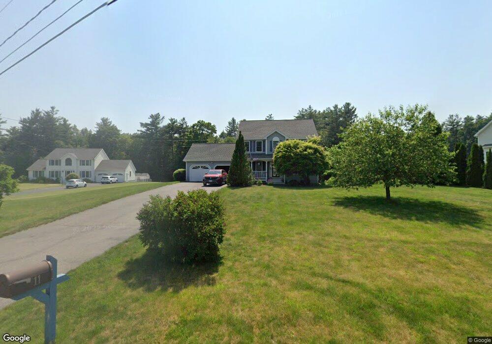
11 Perry Ct Litchfield, NH 03052
Estimated Value: $632,000 - $691,000
3
Beds
3
Baths
2,487
Sq Ft
$266/Sq Ft
Est. Value
About This Home
This home is located at 11 Perry Ct, Litchfield, NH 03052 and is currently estimated at $662,379, approximately $266 per square foot. 11 Perry Ct is a home with nearby schools including Griffin Memorial School, Litchfield Middle School, and Campbell High School.
Ownership History
Date
Name
Owned For
Owner Type
Purchase Details
Closed on
Feb 27, 2020
Sold by
Guerrette Jason
Bought by
Guerrette Hopemarie
Current Estimated Value
Purchase Details
Closed on
Jan 23, 2013
Sold by
Guerrette Hopemarie
Bought by
Guerrette Jason and Guerrette Hopemarie
Home Financials for this Owner
Home Financials are based on the most recent Mortgage that was taken out on this home.
Original Mortgage
$274,475
Interest Rate
3.38%
Mortgage Type
Stand Alone Refi Refinance Of Original Loan
Purchase Details
Closed on
Feb 28, 2005
Sold by
Calusdian Robert F and Calusdian Maura A
Bought by
Guerrette Hopemarie R
Purchase Details
Closed on
Apr 1, 1999
Sold by
R J Moreau Co Inc
Bought by
Calusdian Robert F
Create a Home Valuation Report for This Property
The Home Valuation Report is an in-depth analysis detailing your home's value as well as a comparison with similar homes in the area
Home Values in the Area
Average Home Value in this Area
Purchase History
| Date | Buyer | Sale Price | Title Company |
|---|---|---|---|
| Guerrette Hopemarie | -- | None Available | |
| Guerrette Jason | -- | -- | |
| Guerrette Hopemarie R | $340,000 | -- | |
| Calusdian Robert F | $186,500 | -- |
Source: Public Records
Mortgage History
| Date | Status | Borrower | Loan Amount |
|---|---|---|---|
| Previous Owner | Calusdian Robert F | $302,696 | |
| Previous Owner | Calusdian Robert F | $274,475 | |
| Previous Owner | Calusdian Robert F | $250,394 |
Source: Public Records
Tax History Compared to Growth
Tax History
| Year | Tax Paid | Tax Assessment Tax Assessment Total Assessment is a certain percentage of the fair market value that is determined by local assessors to be the total taxable value of land and additions on the property. | Land | Improvement |
|---|---|---|---|---|
| 2024 | $8,283 | $398,600 | $162,900 | $235,700 |
| 2023 | $8,347 | $398,600 | $162,900 | $235,700 |
| 2022 | $7,585 | $398,600 | $162,900 | $235,700 |
| 2021 | $7,350 | $398,600 | $162,900 | $235,700 |
| 2020 | $7,363 | $396,300 | $162,900 | $233,400 |
| 2019 | $7,774 | $328,700 | $129,900 | $198,800 |
| 2017 | $7,392 | $328,700 | $129,900 | $198,800 |
| 2016 | $7,100 | $328,700 | $129,900 | $198,800 |
| 2015 | $6,699 | $328,700 | $129,900 | $198,800 |
| 2014 | $6,440 | $311,100 | $127,300 | $183,800 |
| 2013 | $6,344 | $308,400 | $127,300 | $181,100 |
Source: Public Records
Map
Nearby Homes
- 41 Century Ln
- 25 Chatfield Dr
- 1 Morrill St
- 1 Tallarico St Unit 2
- 1 Tallarico St Unit 14
- 0 Tallarico St Unit Lot 11 5056385
- 0 Tallarico St Unit 10 5044310
- 0 Tallarico St Unit 25 5043170
- 0 Tallarico St Unit 5041169
- 0 Tallarico St Unit 12 5033131
- 0 Tallarico St Unit 5 5032751
- 0 Tallarico St Unit 3 5032471
- 490 Charles Bancroft Hwy
- 17 Winter Cir
- 3-C Mustang Dr Unit MODEL
- 9 Mustang Dr Unit END UNIT-D
- 9 Mustang Dr Unit C
- 9 Mustang Dr Unit B
- 7 Mustang Dr Unit B
- 7 Mustang Dr Unit END UNIT-A