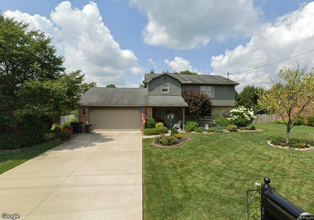
110 Keyser St Marietta, OH 45750
Estimated Value: $325,000 - $341,000
4
Beds
3
Baths
2,068
Sq Ft
$160/Sq Ft
Est. Value
About This Home
This home is located at 110 Keyser St, Marietta, OH 45750 and is currently estimated at $330,850, approximately $159 per square foot. 110 Keyser St is a home located in Washington County with nearby schools including Marietta High School, St. Mary Catholic School, and Marietta Christian School.
Ownership History
Date
Name
Owned For
Owner Type
Purchase Details
Closed on
Sep 2, 2009
Sold by
Cartus Financial Corporation
Bought by
Cunningham James W and Cunningham Patti J
Current Estimated Value
Purchase Details
Closed on
Sep 23, 2008
Sold by
Powers Jeffrey J and Powers Teresa M
Bought by
Cartus Financial Corporation
Purchase Details
Closed on
Jun 16, 2006
Sold by
Flygar Robert L and Flygar Margaret
Bought by
Powers Jeffrey J and Powers Teresa M
Home Financials for this Owner
Home Financials are based on the most recent Mortgage that was taken out on this home.
Original Mortgage
$196,000
Interest Rate
6.12%
Mortgage Type
Purchase Money Mortgage
Purchase Details
Closed on
May 11, 1990
Bought by
Flygar Robert L and Flygar Margar
Purchase Details
Closed on
Sep 25, 1989
Create a Home Valuation Report for This Property
The Home Valuation Report is an in-depth analysis detailing your home's value as well as a comparison with similar homes in the area
Home Values in the Area
Average Home Value in this Area
Purchase History
| Date | Buyer | Sale Price | Title Company |
|---|---|---|---|
| Cunningham James W | $200,000 | Fidelity National Title | |
| Cartus Financial Corporation | $200,000 | Fidelity National Title | |
| Powers Jeffrey J | $245,000 | Multiple | |
| Flygar Robert L | $118,800 | -- | |
| Flygar Robert L | $118,800 | -- | |
| -- | $117,300 | -- | |
| -- | $117,300 | -- |
Source: Public Records
Mortgage History
| Date | Status | Borrower | Loan Amount |
|---|---|---|---|
| Previous Owner | Powers Jeffrey J | $196,000 |
Source: Public Records
Tax History Compared to Growth
Tax History
| Year | Tax Paid | Tax Assessment Tax Assessment Total Assessment is a certain percentage of the fair market value that is determined by local assessors to be the total taxable value of land and additions on the property. | Land | Improvement |
|---|---|---|---|---|
| 2024 | $2,570 | $81,680 | $10,930 | $70,750 |
| 2023 | $2,570 | $81,680 | $10,930 | $70,750 |
| 2022 | $2,587 | $81,680 | $10,930 | $70,750 |
| 2021 | $2,477 | $74,220 | $10,720 | $63,500 |
| 2020 | $2,489 | $74,220 | $10,720 | $63,500 |
| 2019 | $2,484 | $74,220 | $10,720 | $63,500 |
| 2018 | $2,407 | $70,150 | $9,320 | $60,830 |
| 2017 | $2,402 | $70,150 | $9,320 | $60,830 |
| 2016 | $4,782 | $70,150 | $9,320 | $60,830 |
| 2015 | $2,190 | $62,430 | $9,150 | $53,280 |
| 2014 | $4,262 | $62,430 | $9,150 | $53,280 |
| 2013 | $1,093 | $62,430 | $9,150 | $53,280 |
Source: Public Records
Map
Nearby Homes
- 207 Lindsey Ave
- 101 Ellsworth Dr
- 402 Keeler Dr
- 110 Alden Ave
- 200 Bohl Dr
- 106 Marshall Rd
- 00 Marshall Rd
- 100 Maple Shade Dr
- 102 Woodrow St
- 202 Deerwalk Cir
- 520 Millgate Rd
- 101 Winters Dr
- 40 Masonic Park Ln
- 315 Muskingum Dr
- 0 Academy Dr
- 1126 Colegate Dr
- 120 Woodcrest Dr
- 107 Strecker Hill
- 1099 Colegate Dr
- 760 Lang Farm Rd