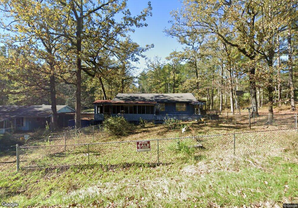
110 Sir Richard Rd Brandon, MS 39042
Estimated Value: $46,000 - $143,000
3
Beds
1
Bath
1,477
Sq Ft
$65/Sq Ft
Est. Value
About This Home
This home is located at 110 Sir Richard Rd, Brandon, MS 39042 and is currently estimated at $95,401, approximately $64 per square foot. 110 Sir Richard Rd is a home located in Rankin County with nearby schools including McLaurin Elementary School.
Ownership History
Date
Name
Owned For
Owner Type
Purchase Details
Closed on
Apr 25, 2025
Sold by
Wallace Thomas and Wallace Cheryl
Bought by
Creative Home Group Llc
Current Estimated Value
Purchase Details
Closed on
Aug 2, 2016
Sold by
Charles Dyer
Bought by
Robertson Jacob and Roan Saisha
Home Financials for this Owner
Home Financials are based on the most recent Mortgage that was taken out on this home.
Original Mortgage
$72,504
Outstanding Balance
$57,060
Interest Rate
3.48%
Estimated Equity
$38,341
Purchase Details
Closed on
Jun 28, 2016
Sold by
Dortch Pamela Ann
Bought by
Atkinson William M
Home Financials for this Owner
Home Financials are based on the most recent Mortgage that was taken out on this home.
Original Mortgage
$72,504
Outstanding Balance
$57,060
Interest Rate
3.48%
Estimated Equity
$38,341
Create a Home Valuation Report for This Property
The Home Valuation Report is an in-depth analysis detailing your home's value as well as a comparison with similar homes in the area
Purchase History
| Date | Buyer | Sale Price | Title Company |
|---|---|---|---|
| Creative Home Group Llc | -- | None Listed On Document | |
| Robertson Jacob | -- | -- | |
| Atkinson William M | -- | Attorney |
Source: Public Records
Mortgage History
| Date | Status | Borrower | Loan Amount |
|---|---|---|---|
| Open | Robertson Jacob | $19,014 | |
| Open | Robertson Jacob | $72,504 | |
| Closed | Robertson Jacob | -- |
Source: Public Records
Tax History
| Year | Tax Paid | Tax Assessment Tax Assessment Total Assessment is a certain percentage of the fair market value that is determined by local assessors to be the total taxable value of land and additions on the property. | Land | Improvement |
|---|---|---|---|---|
| 2025 | $356 | $5,213 | $0 | $0 |
| 2024 | $346 | $5,213 | $0 | $0 |
| 2023 | -- | $3,083 | $0 | $0 |
| 2022 | -- | $3,083 | $0 | $0 |
| 2021 | $0 | $3,083 | $0 | $0 |
| 2020 | $0 | $3,083 | $0 | $0 |
| 2019 | $0 | $2,699 | $0 | $0 |
| 2018 | $0 | $2,699 | $0 | $0 |
| 2017 | $0 | $2,699 | $0 | $0 |
| 2016 | $0 | $2,624 | $0 | $0 |
| 2015 | -- | $2,624 | $0 | $0 |
| 2014 | -- | $2,624 | $0 | $0 |
| 2013 | -- | $2,624 | $0 | $0 |
Source: Public Records
Map
Nearby Homes
- 110 Sir Richard Rd
- 112 Sir Richard Rd
- 1178 Sanctuary Dr
- 1142 Sanctuary Dr
- 0 Sir Guy Ln
- 0 Will Stutely Dr
- 321 Stronghold Dr
- 1392 Old Lake Rd
- 305 Stronghold Dr
- 306 Stronghold Dr
- 312 Stronghold Dr
- 310 Stronghold Dr
- 217 New Haven Ln
- 325 Stronghold Dr
- 308 Stronghold Dr
- 176 Will Stutely Dr
- 538 Stone Brook Place
- 536 Stone Brook Place
- 534 Stone Brook Place
- 532 Stone Brook Place
- 51 Canterbury Ln
- 112 Sir Richard Rd Unit A
- 113 Touchstone Rd
- 101 Sir Richard Rd
- 119 Touchstone Rd
- 120 Sir Richard Rd
- 106 Shamrock Dr
- 102 Lilac Dr
- 119 Sir Richard Rd
- 135 Robinhood Trail
- 114 Lilac Dr
- 0 Will Stutley Dr
- 2 Will Stutley Dr
- 1 Will Stutley Dr
- 3 Will Stutley Dr
- 111 Friar Tuck Dr
- 111 Friar Tuck Dr Unit 4 & 13 BLK 13 Sherwo
- 112 Lilac Dr
- 120 Lilac Dr
- 113 Friar Tuck Dr
Your Personal Tour Guide
Ask me questions while you tour the home.