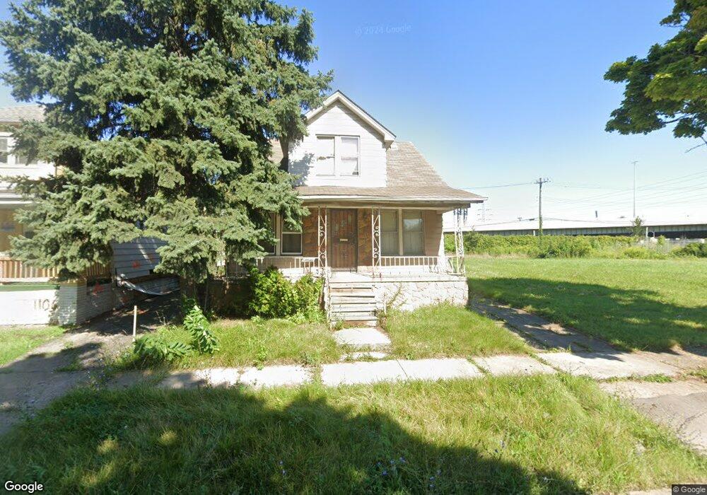
1100 S Patricia St Detroit, MI 48217
Boynton NeighborhoodEstimated Value: $68,000 - $116,000
--
Bed
1
Bath
1,152
Sq Ft
$77/Sq Ft
Est. Value
About This Home
This home is located at 1100 S Patricia St, Detroit, MI 48217 and is currently estimated at $88,925, approximately $77 per square foot. 1100 S Patricia St is a home located in Wayne County with nearby schools including Mark Twain Elementary-Middle School, Charles L. Spain Elementary-Middle School, and Edward 'Duke' Ellington Conservatory of Music and Art.
Ownership History
Date
Name
Owned For
Owner Type
Purchase Details
Closed on
Mar 25, 2025
Sold by
United Community Housing Coalition
Bought by
Miles James
Current Estimated Value
Purchase Details
Closed on
Sep 16, 2019
Sold by
Miles James O
Bought by
United Community Housing Coalition
Home Financials for this Owner
Home Financials are based on the most recent Mortgage that was taken out on this home.
Original Mortgage
$2,603
Interest Rate
3.5%
Mortgage Type
Land Contract Argmt. Of Sale
Purchase Details
Closed on
Nov 18, 2015
Sold by
Treasurer Of The Charter County Of Wayne
Bought by
Miles James O
Create a Home Valuation Report for This Property
The Home Valuation Report is an in-depth analysis detailing your home's value as well as a comparison with similar homes in the area
Home Values in the Area
Average Home Value in this Area
Purchase History
| Date | Buyer | Sale Price | Title Company |
|---|---|---|---|
| Miles James | -- | None Listed On Document | |
| United Community Housing Coalition | -- | None Available | |
| Miles James O | $2,603 | None Available | |
| Miles James O | $1,100 | None Available |
Source: Public Records
Mortgage History
| Date | Status | Borrower | Loan Amount |
|---|---|---|---|
| Previous Owner | Miles James O | $2,603 |
Source: Public Records
Tax History Compared to Growth
Tax History
| Year | Tax Paid | Tax Assessment Tax Assessment Total Assessment is a certain percentage of the fair market value that is determined by local assessors to be the total taxable value of land and additions on the property. | Land | Improvement |
|---|---|---|---|---|
| 2025 | $581 | $16,600 | $0 | $0 |
| 2024 | $581 | $13,500 | $0 | $0 |
| 2023 | $562 | $10,070 | $0 | $0 |
| 2022 | $600 | $7,500 | $0 | $0 |
| 2021 | $589 | $5,500 | $0 | $0 |
| 2020 | $584 | $4,900 | $0 | $0 |
| 2019 | $512 | $3,870 | $0 | $0 |
| 2018 | $486 | $4,300 | $0 | $0 |
| 2017 | $78 | $4,100 | $0 | $0 |
| 2016 | $714 | $7,000 | $0 | $0 |
| 2015 | $700 | $7,000 | $0 | $0 |
| 2013 | $771 | $7,710 | $0 | $0 |
| 2010 | -- | $11,047 | $453 | $10,594 |
Source: Public Records
Map
Nearby Homes
- 769 S Liddesdale St
- 1415 S Liddesdale St
- 1483 S Annabelle St
- 1501 S Annabelle St
- 1520 S Beatrice St
- 1320 S Bassett St
- 2580 S Schaefer Hwy
- 530 S Colonial St
- 315 Beechwood St
- 2400 Schaefer Hwy
- 147 Charles St
- 140 Division St
- 412 Campbell St
- 2400 S Annabelle St
- 193 Division St
- 17150 Flora St
- 17206 Flora St
- 22 W Henry St
- 17 W James St
- 17083 Dora St
- 1090 S Patricia St
- 1106 S Patricia St
- 1112 S Patricia St
- 1124 S Patricia St
- 1070 S Patricia St
- 1126 S Patricia St
- 1078 S Patricia St
- 1132 S Patricia St
- 1085 S Patricia St
- 1086 S Patricia St
- 1064 S Patricia St
- 1056 S Patricia St
- 1101 S Patricia St
- 1109 S Patricia St
- 1115 S Patricia St
- 1127 S Patricia St
- 1093 S Patricia St
- 1121 S Patricia St
- 1065 S Patricia St
- 1079 S Patricia St