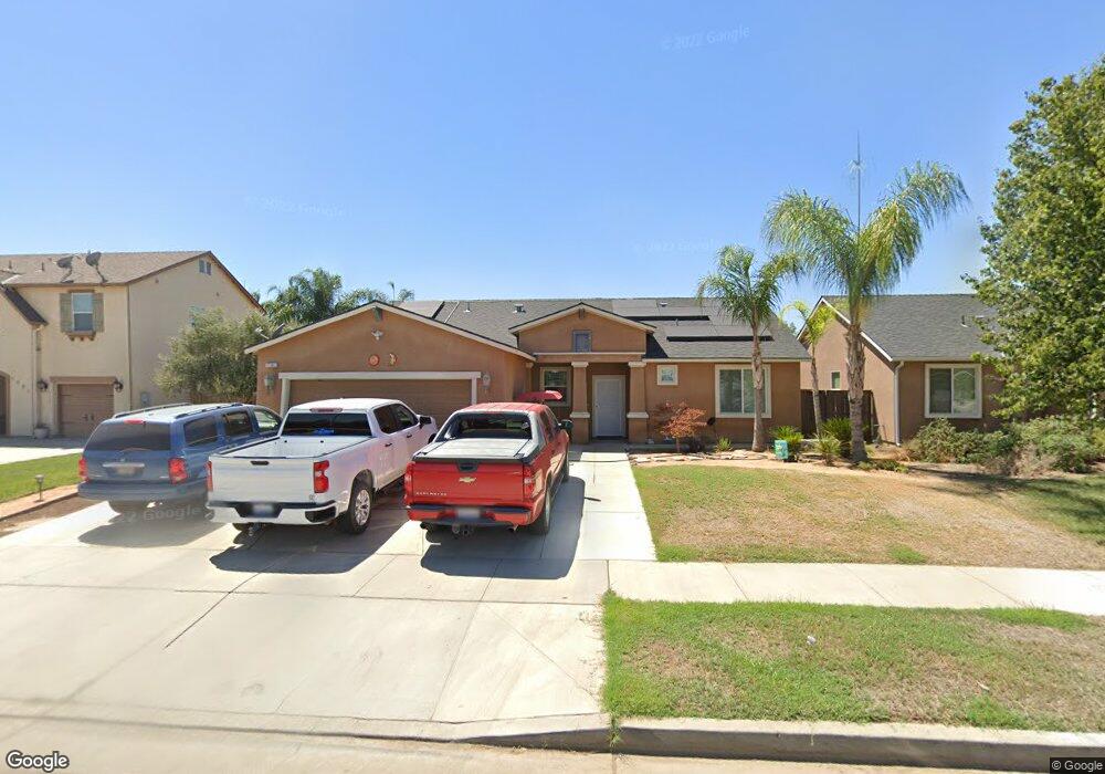
1101 Timothy Ave Dinuba, CA 93618
Estimated Value: $363,010 - $440,000
4
Beds
2
Baths
1,562
Sq Ft
$256/Sq Ft
Est. Value
About This Home
This home is located at 1101 Timothy Ave, Dinuba, CA 93618 and is currently estimated at $399,503, approximately $255 per square foot. 1101 Timothy Ave is a home located in Tulare County with nearby schools including Roosevelt Elementary School, Washington Intermediate School, and Dinuba High School.
Ownership History
Date
Name
Owned For
Owner Type
Purchase Details
Closed on
Aug 5, 2010
Sold by
Skyview Crest Lp
Bought by
Corona Salvador Banda and Banda Jeanette
Current Estimated Value
Home Financials for this Owner
Home Financials are based on the most recent Mortgage that was taken out on this home.
Original Mortgage
$171,623
Interest Rate
4.35%
Mortgage Type
New Conventional
Create a Home Valuation Report for This Property
The Home Valuation Report is an in-depth analysis detailing your home's value as well as a comparison with similar homes in the area
Home Values in the Area
Average Home Value in this Area
Purchase History
| Date | Buyer | Sale Price | Title Company |
|---|---|---|---|
| Corona Salvador Banda | $166,000 | First American Title Company |
Source: Public Records
Mortgage History
| Date | Status | Borrower | Loan Amount |
|---|---|---|---|
| Previous Owner | Corona Salvador Banda | $171,623 |
Source: Public Records
Tax History
| Year | Tax Paid | Tax Assessment Tax Assessment Total Assessment is a certain percentage of the fair market value that is determined by local assessors to be the total taxable value of land and additions on the property. | Land | Improvement |
|---|---|---|---|---|
| 2025 | $2,667 | $212,416 | $51,245 | $161,171 |
| 2024 | $2,667 | $208,252 | $50,241 | $158,011 |
| 2023 | $2,630 | $204,169 | $49,256 | $154,913 |
| 2022 | $2,507 | $200,167 | $48,291 | $151,876 |
| 2021 | $2,453 | $196,242 | $47,344 | $148,898 |
| 2020 | $2,480 | $194,230 | $46,859 | $147,371 |
| 2019 | $2,505 | $190,421 | $45,940 | $144,481 |
| 2018 | $2,425 | $186,687 | $45,039 | $141,648 |
| 2017 | $2,395 | $183,027 | $44,156 | $138,871 |
| 2016 | $2,294 | $175,000 | $44,000 | $131,000 |
| 2015 | $2,217 | $176,000 | $44,000 | $132,000 |
| 2014 | $2,217 | $160,000 | $40,000 | $120,000 |
Source: Public Records
Map
Nearby Homes
- 900 Heather Ave
- 372 N Smith Ave
- 435 N Alta Ave
- 346 Village Dr
- 1306 Country Place
- 337 Village Dr
- 1449 Crimson Way
- 1237 Chestnut Ln
- 683 N Villa Ave
- 1755 W Rosemary Ave Unit Mb65
- 1755 W Rosemary Ave Unit Lot 65
- 1723 W Rosemary Ave Unit Lot 63
- 1695 W Rosemary Ave Unit Lot 61
- 42162 Road 72
- 42682 Road 72
- 7301 Avenue 424
- 1695 Rosemary Ave Unit Mb61
- 1787 Rosemary Ave Unit Mb67
- 1815 Rosemary Ave Unit Mb69
- 1863 Rosemary Ave Unit Mb71
- 1147 Timothy Ave
- 1091 Timothy Ave
- 1100 Heather Ave
- 1146 Heather Ave
- 1090 Heather Ave
- 1071 Timothy Ave
- 1176 Heather Ave
- 1070 Heather Ave
- 1197 Timothy Ave
- 1051 Timothy Ave
- 1196 Heather Ave
- 1050 Heather Ave
- 1201 Timothy Ave
- 1001 Timothy Ave
- 1200 Heather Ave
- 785 Mayflower Ave
- 784 Mayflower Ave
- 1000 Heather Ave
- 1267 Timothy Ave
- 997 Timothy Ave
Your Personal Tour Guide
Ask me questions while you tour the home.