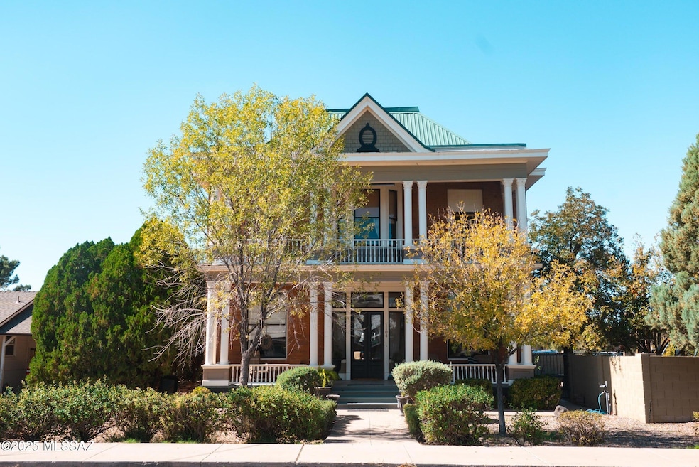
1104 S Central Ave Safford, AZ 85546
Estimated payment $3,698/month
Highlights
- City View
- Deck
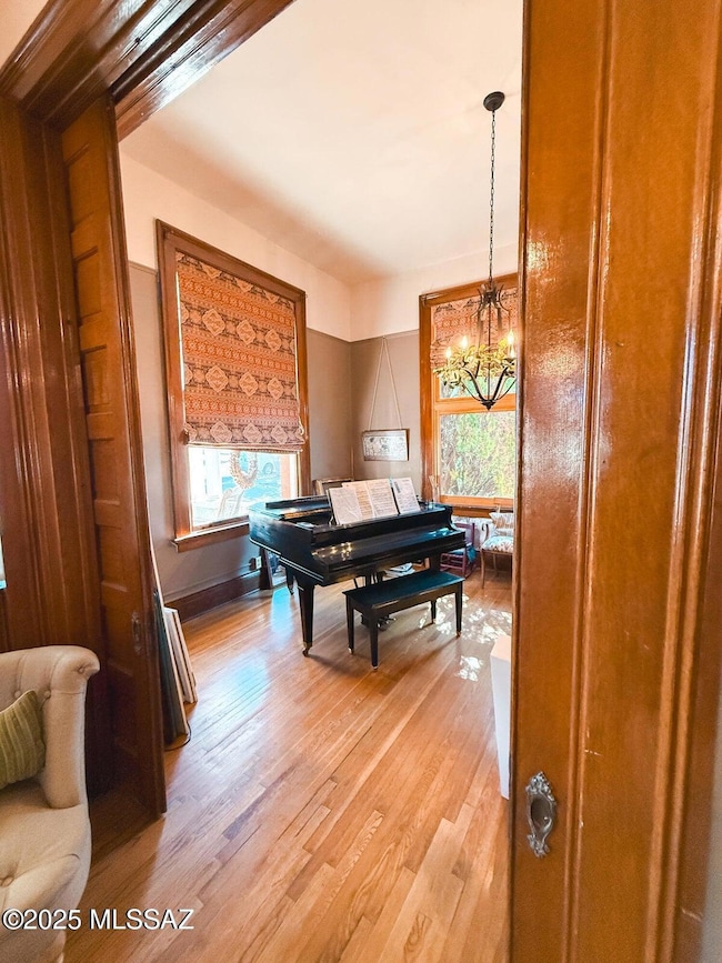
- Wood Flooring
- Fireplace in Primary Bedroom
- Vaulted Ceiling
- Bonus Room
About This Home
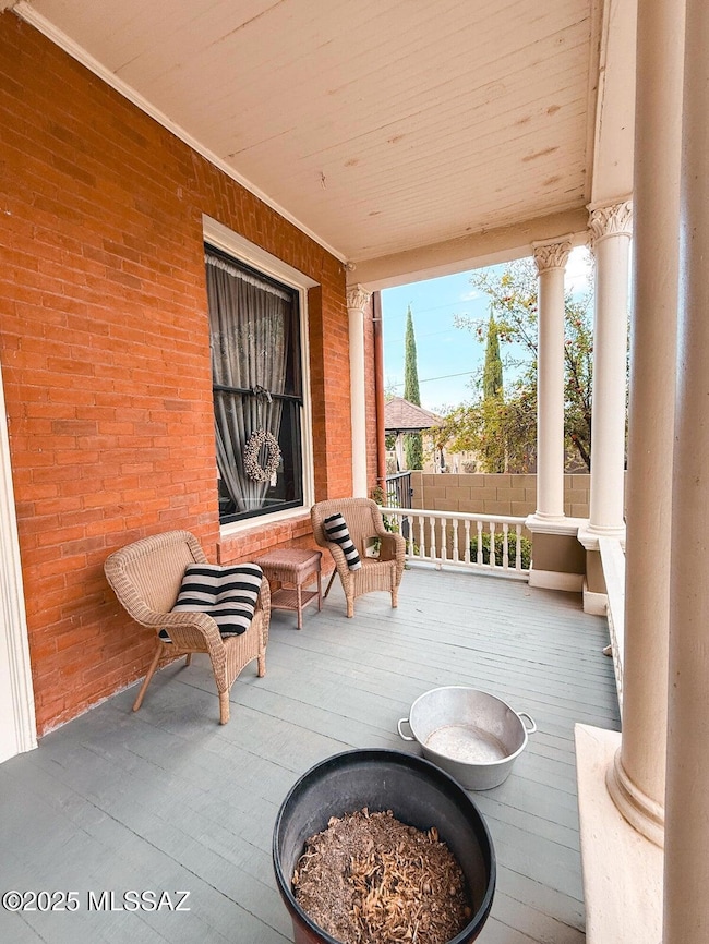
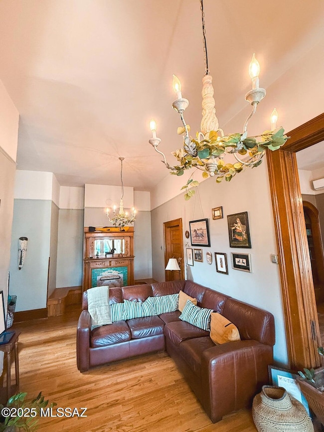
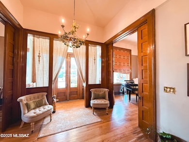
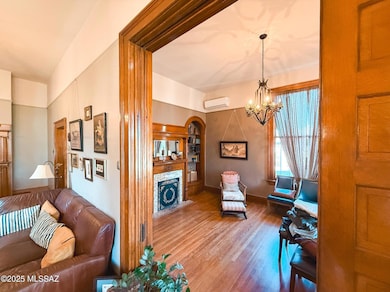
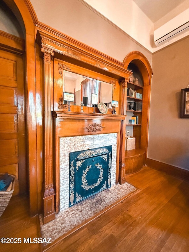
Own a Piece of Arizona History - The Olney House & Cottage Bed and Breakfast- Now is your chance to own a timeless historical property with incredible charm, income potential, and deep roots in the community. Originally known as The Olney House, this iconic residence—currently operating as The Cottage Bed & Breakfast—offers over 4,200 sq. ft. of unique and versatile space spread across multiple buildings on over 1/3 of an acre. Built in 1890, this property blends master craftsmanship with modern versatility, and is surrounded by lush porches, shade trees, and garden charm. Property Features: The Main House is set up as a two-bedroom, one-bath apartment upstairs with open-concept living and dining areas. The downstairs features an additional 1-b
Home Details
Home Type
- Single Family
Est. Annual Taxes
- $1,145
Year Built
- Built in 1890
Lot Details
- 0.36 Acre Lot
- Desert faces the front and back of the property
- East or West Exposure
- Block Wall Fence
- Shrub
- Corner Lot
- Drip System Landscaping
- Landscaped with Trees
- Garden
- Property is zoned Other - CALL
Parking
- Driveway
Property Views
- City
- Mountain
Home Design
- Brick or Stone Mason
- Metal Roof
Interior Spaces
- 4,075 Sq Ft Home
- 2-Story Property
- Vaulted Ceiling
- Ceiling Fan
- Wood Burning Fireplace
- Window Treatments
- Entrance Foyer
- Family Room Off Kitchen
- Living Room with Fireplace
- 5 Fireplaces
- Bonus Room
- Wood Flooring
- Alarm System
- Laundry in Bathroom
Kitchen
- Breakfast Bar
- Butlers Pantry
- Gas Range
- Dishwasher
- Kitchen Island
- Butcher Block Countertops
Bedrooms and Bathrooms
- 5 Bedrooms
- Fireplace in Primary Bedroom
- Fireplace in Primary Bedroom Retreat
- Studio bedroom
- 4 Full Bathrooms
- Shower Only in Secondary Bathroom
- Primary Bathroom includes a Walk-In Shower
Outdoor Features
- Balcony
- Courtyard
- Deck
- Covered Patio or Porch
- Shed
- Play Equipment
Additional Homes
- Fireplace in Guest House
Schools
- Safford Elementary School
- Safford Middle School
- Safford High School
Utilities
- Forced Air Heating and Cooling System
- Natural Gas Water Heater
- High Speed Internet
Community Details
- No Home Owners Association
Map
Home Values in the Area
Average Home Value in this Area
Tax History
| Year | Tax Paid | Tax Assessment Tax Assessment Total Assessment is a certain percentage of the fair market value that is determined by local assessors to be the total taxable value of land and additions on the property. | Land | Improvement |
|---|---|---|---|---|
| 2026 | $1,145 | -- | -- | -- |
| 2025 | $1,145 | $33,083 | $2,129 | $30,954 |
| 2024 | $1,201 | $31,255 | $2,129 | $29,126 |
| 2023 | $1,201 | $26,181 | $1,962 | $24,219 |
| 2022 | $1,195 | $22,804 | $1,962 | $20,842 |
| 2021 | $1,287 | $0 | $0 | $0 |
| 2020 | $1,246 | $0 | $0 | $0 |
| 2019 | $1,303 | $0 | $0 | $0 |
| 2018 | $1,213 | $0 | $0 | $0 |
| 2017 | $1,103 | $0 | $0 | $0 |
| 2016 | $1,027 | $0 | $0 | $0 |
| 2015 | $932 | $0 | $0 | $0 |
Property History
| Date | Event | Price | List to Sale | Price per Sq Ft |
|---|---|---|---|---|
| 11/17/2025 11/17/25 | For Sale | $685,000 | -- | $168 / Sq Ft |
Purchase History
| Date | Type | Sale Price | Title Company |
|---|---|---|---|
| Warranty Deed | -- | -- | |
| Warranty Deed | -- | None Listed On Document | |
| Interfamily Deed Transfer | -- | None Available | |
| Warranty Deed | -- | Pioneer Title Agency |
Source: MLS of Southern Arizona
MLS Number: 22529835
APN: 101-07-121
Disclaimer: Certain information contained herein is derived from information provided by parties other than Homes.com. All information provided is deemed reliable, but is not guaranteed to be accurate and should be independently verified.
![]() The data relating to real estate listings on this website comes in part from the Internet Data Exchange (IDX) program of Multiple Listing Service of Southern Arizona. IDX information is provided exclusively for consumers' personal, non-commercial use and may not be used for any purpose other than to identify prospective properties consumers may be interested in purchasing. Listings provided by brokerages other than Ten-X are identified with the MLSSAZ IDX Logo. All Information Is Deemed Reliable But Is Not Guaranteed Accurate. Listing information Copyright 2025 MLS of Southern Arizona. All Rights Reserved.
The data relating to real estate listings on this website comes in part from the Internet Data Exchange (IDX) program of Multiple Listing Service of Southern Arizona. IDX information is provided exclusively for consumers' personal, non-commercial use and may not be used for any purpose other than to identify prospective properties consumers may be interested in purchasing. Listings provided by brokerages other than Ten-X are identified with the MLSSAZ IDX Logo. All Information Is Deemed Reliable But Is Not Guaranteed Accurate. Listing information Copyright 2025 MLS of Southern Arizona. All Rights Reserved.
- 1116 S 6th Ave
- 1204 S 1st Ave
- 1210 S 1st Ave
- 120 Relation St Unit 2
- 813 W 13th St
- 1108 S 9th Ave
- 115 W 15th St
- 616 W 7th St
- 1101 S 9th Place
- 1309 S Bingham Place
- 603 W 16th St
- 818 W 7th St Unit A
- 1536 W Cherokee Ln
- 1115 W Relation St
- 216 S 6th Ave
- 1906 S Elm Ave
- 832 W Stirrup Dr
- 1609 S 12th Ave
- 222 E 20th St
- 1808 Mesa Cir
