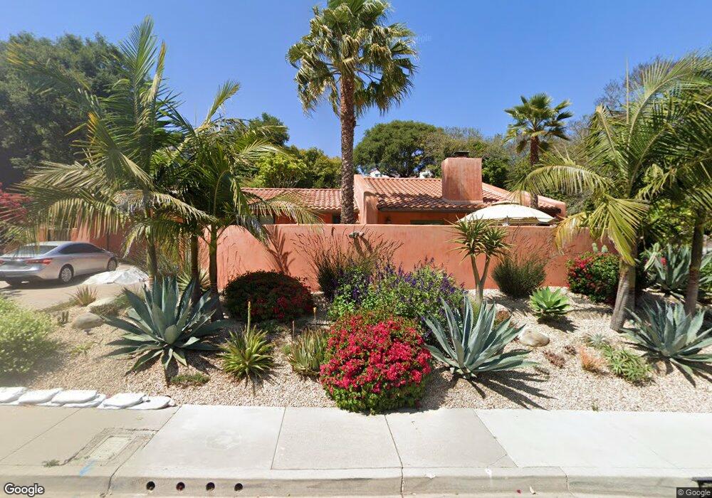
1112 Manitou Rd Santa Barbara, CA 93101
Bel Air Knolls NeighborhoodEstimated Value: $1,624,000 - $2,295,533
3
Beds
2
Baths
2,092
Sq Ft
$926/Sq Ft
Est. Value
About This Home
This home is located at 1112 Manitou Rd, Santa Barbara, CA 93101 and is currently estimated at $1,936,883, approximately $925 per square foot. 1112 Manitou Rd is a home located in Santa Barbara County with nearby schools including Harding University Partnership, La Cumbre Junior High School, and San Marcos Senior High School.
Ownership History
Date
Name
Owned For
Owner Type
Purchase Details
Closed on
Feb 3, 2021
Sold by
Buford Richard O and Buford Carolyn Gray
Bought by
Buford Richard O and Buford Carolyn Gray
Current Estimated Value
Purchase Details
Closed on
Sep 30, 2011
Sold by
Buford Richard O and Buford Carolyn Gray
Bought by
Buford Richard O and Buford Carolyn Gray
Purchase Details
Closed on
Dec 22, 2010
Sold by
Buford Richard O and Buford Carolyn Gray
Bought by
Buford Richard O and Buford Carolyn Gray
Home Financials for this Owner
Home Financials are based on the most recent Mortgage that was taken out on this home.
Original Mortgage
$238,500
Interest Rate
4.84%
Mortgage Type
New Conventional
Purchase Details
Closed on
Oct 14, 1995
Sold by
Buford Richard and Buford Carolyn G
Bought by
Buford Richard O and Buford Carolyn Gray
Create a Home Valuation Report for This Property
The Home Valuation Report is an in-depth analysis detailing your home's value as well as a comparison with similar homes in the area
Home Values in the Area
Average Home Value in this Area
Purchase History
| Date | Buyer | Sale Price | Title Company |
|---|---|---|---|
| Buford Richard O | -- | None Available | |
| Buford Richard O | -- | None Available | |
| Buford Richard O | -- | None Available | |
| Buford Richard O | -- | -- |
Source: Public Records
Mortgage History
| Date | Status | Borrower | Loan Amount |
|---|---|---|---|
| Closed | Buford Richard O | $238,500 |
Source: Public Records
Tax History
| Year | Tax Paid | Tax Assessment Tax Assessment Total Assessment is a certain percentage of the fair market value that is determined by local assessors to be the total taxable value of land and additions on the property. | Land | Improvement |
|---|---|---|---|---|
| 2025 | $8,105 | $784,932 | $339,648 | $445,284 |
| 2023 | $8,105 | $754,454 | $326,460 | $427,994 |
| 2022 | $7,817 | $739,661 | $320,059 | $419,602 |
| 2021 | $7,635 | $725,159 | $313,784 | $411,375 |
| 2020 | $7,556 | $717,724 | $310,567 | $407,157 |
| 2019 | $7,423 | $703,652 | $304,478 | $399,174 |
| 2018 | $7,086 | $668,292 | $298,508 | $369,784 |
| 2017 | $6,851 | $655,189 | $292,655 | $362,534 |
| 2016 | $6,741 | $642,343 | $286,917 | $355,426 |
| 2014 | $6,413 | $606,580 | $277,073 | $329,507 |
Source: Public Records
Map
Nearby Homes
- 1815 Mountain Ave
- 1275 Calle Cerrito
- 834 W Valerio St
- 1010 Portesuello Ave
- 36 Tinker Way
- 1545 W Valerio St
- 1144 Portesuello Ave
- 711 Eucalyptus Ave
- 1324 Kenwood Rd
- 610 W Valerio St
- 714 W Sola St
- 2117 Oak Park Ln
- 920 Flora Vista Dr
- 1407 San Pascual St Unit D
- 2019 Castillo St
- 2203 Parkway Dr
- 1520 Portesuello Ave
- 1050 Vista Del Pueblo Unit 12
- 1204 San Andres St
- 1917 Bath St
- 1106 Manitou Rd
- 1118 Manitou Rd
- 1100 Manitou Rd
- 1121 Manitou Rd
- 1111 Manitou Rd
- 1101 Manitou Rd
- 1124 Manitou Rd
- 1050 Manitou Rd
- 1106 Nirvana Rd
- 1114 Nirvana Rd
- 1102 Nirvana Rd
- 1110 Nirvana Rd
- 1123 Manitou Rd
- 1118 Nirvana Rd
- 1132 Manitou Rd
- 1057 Manitou Rd
- 0000 Manatou
- 1822 Clearview Rd
- 1809 Hillside Rd
- 1225 Manitou Ln
Your Personal Tour Guide
Ask me questions while you tour the home.